Honduras
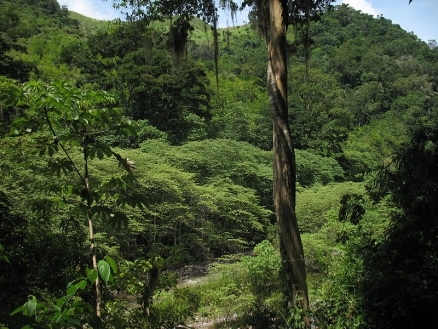
Montañas de la Sierra de Agalta, Olancho. Honduras. Source: Dennis Garcia./Wikimedia Commons
Countries and Regions of the World Collection  Honduras (formerly "Spanish Honduras") is a Central American nation of over eight million people between Guatemala (to the northeast) and Nicaragua (to the south) and bordering El Salvador to the southwest.
Honduras' northern coast fronts the Caribbean Sea, including the virtually uninhabited eastern Mosquito Coast, whiles its much shorter southwestern coast fronts the Gulf of Fonseca on the North Pacific Ocean.

|
|

Its main environmental issues include:
- urban population expanding;
- deforestation results from logging and the clearing of land for agricultural purposes;
- further land degradation and soil erosion hastened by uncontrolled development and improper land use practices such as farming of marginal lands;
- mining activities polluting Lago de Yojoa (the country's largest source of fresh water), as well as several rivers and streams, with heavy metals
It is extremely susceptible to damaging hurricanes and floods along the Caribbean coast, and to frequent, but generally mild, earthquakes.
Once part of Spain's vast empire in the New World, Honduras became an independent nation in 1821.
After two and a half decades of mostly military rule, a freely elected civilian government came to power in 1982. During the 1980s, Honduras proved a haven for anti-Sandinista contras fighting the Marxist Nicaraguan Government and an ally to Salvadoran Government forces fighting leftist guerrillas.
The country was devastated by Hurricane Mitch in 1998, which killed about 5,600 people and caused approximately $2 billion in damage. Since then, the economy has slowly rebounded.
Nearly half of Honduras's economic activity is directly tied to the United States, with exports to the US accounting for 30% of GDP and remittances for another 20%.
Contents
Geography
Location: Central America, bordering the Caribbean Sea, between Guatemala and Nicaragua and bordering the Gulf of Fonseca (North Pacific Ocean), between El Salvador and Nicaragua.
Geographic Coordinates: 15 00 N, 86 30 W
|
|
|
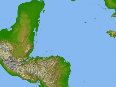
| Topography of Honduras. Source: Wikimedia Commons | Satellite radar topography image of a portion of Central America. Due to persistent cloud cover, obtaining conventional high-altitude photos of this region is extrordinarily difficult. Radar's ability to penetrate clouds and make 3-D measurements allowed scientists to generate the first complete high-resolution topographic map of the entire region. All of Guatemala, Belize, El Salvador, and Honduras are visible on this image, as well as a considerable portion of southern Mexico (the Yucatan Peninsula). Image courtesy of NASA/JPL/NGA. |

Area: 112,090 sq km (111,890 sq km of land, 200 sq km of water)
arable land: 3.05%
permanent crops: 1.39%
other: 95.56% (2005)
Land Boundaries: 1,520 km - Guatemala 256 km, El Salvador 342 km, Nicaragua 922 km
In 1969, El Salvador and Honduras fought the brief "Soccer War" over disputed border areas. The two countries formally signed a peace treaty in 1980, which put the border dispute before the International Court of Justice (ICJ). In 1992, the IJC awarded most of the disputed territory to Honduras, and in January 1998, Honduras and El Salvador signed a border demarcation treaty to implement the terms of the ICJ decree, although delays continue due to technical difficulties. However, Honduras and El Salvador maintain normal diplomatic and trade relations. Honduras also has unresolved maritime border disputes with El Salvador, Jamaica, and Cuba.
Coastline: 832 km - Caribbean Sea 669 km; Gulf of Fonseca 163 km
Maritime Claims:
territorial sea: 12 nm
contiguous zone: 24 nm
exclusive economic zone: 200 nm
continental shelf: natural extension of territory or to 200 nm
Natural Hazards: Frequent, but generally mild, earthquakes; extremely susceptible to damaging hurricanes and floods along the Caribbean coast.
Terrain: Mostly mountains in interior, narrow coastal plains.
Climate: Subtropical in lowlands, temperate in mountains.
|
Hurricane Mitch On October 24, 1998, Atlantic Tropical Storm Mitch was upgraded to a hurricane that developed into one of the strongest and most damaging storms to ever hit the Caribbean and Central America. At its height on October 26 and 27, the hurricane had sustained winds of 180 mph and dumped heavy rains over Central America. Although the winds diminished as Hurricane Mitch traveled inland over Honduras on October 30, the storm continued to produce torrential rains, reaching a rate of more than 4 inches per hour, which caused catastrophic floods and landslides throughout the region. Honduras suffered the brunt of Hurricane Mitch. After being stalled for more than two days off the country's northern coast, the storm traveled inland during October 30 and 31. Extensive wind damage and devastating floods occurred nationwide, but particularly on the northern seaboard and in the Bay Islands (located off the northern coast of Honduras, in the Caribbean). It was reported that 6,600 persons were killed, 8,052 injured and 11,998 were missing. Approximately 1.4 million persons were left homeless. More than 92 bridges had been damaged or destroyed, and nearly 70 percent of crops were destroyed. |
|
|

Ecology and Biodiversity
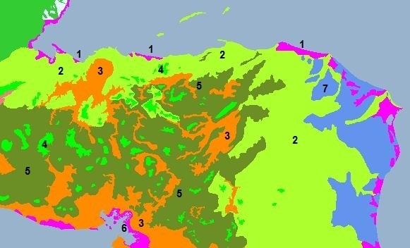
The region is a part of the Mesoamerica Biodiversity Hotspot because of the numerous plant and animal species that can be found there. The country hosts more than 6,000 species of vascular plants, of which 630 (described so far) are orchids; around 250 reptiles and amphibians, more than 700 bird species, and 110 mammal species, half of them being bats.
|
1. Mesoamerican Gulf-Caribbean mangroves/Northern Honduras mangroves/Mosquitia-Nicaraguan Caribbean Coast mangroves 2. Central American Atlantic moist forests 3. Central American dry forests 4. Central American montane forests 5. Central American pine-oak forests 6. Southern Mesoamerican Pacific mangroves 7. Meskito pine forests |
|
Protected Areas
In the northeastern region of La Mosquitia lies the Río Plátano Biosphere Reserve, a lowland rainforest which is home to a great diversity of life. The reserve was added to the UNESCO World Heritage Sites List in 1982.
People and Society
Population: 8,296,693 (July 2012 est.)
Ethnic groups: mestizo (mixed Amerindian and European) 90%, Amerindian 7%, black 2%, white 1%
Age Structure:
0-14 years: 36.7% (male 1,528,271/female 1,464,428)
15-64 years: 59.5% (male 2,431,607/female 2,412,951)
65 years and over: 3.8% (male 136,035/female 170,272) (2011 est.)
Population Growth Rate: 1.838% (2012 est.)
|
|
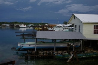
| Shoreline view on Utila, the third largest of the Bay Islands (Islas de la Bahia). Source: CIAWorld Factbook |
|
|
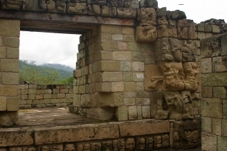
| The Mayan ruins of Copan. Source: CIAWorld Factbook |
|
|
| Sierra de Agalta National Park. Source: Dennis Garcia/Wikimedia Commons |

Birthrate: 24.66 births/1,000 population (2012 est.)
Death Rate: 5.05 deaths/1,000 population (July 2012 est.)
Net migration rate: -1.22 migrant(s)/1,000 population (2012 est.)
Life Expectancy at Birth: 70.71 years (2012 est.)
Total Fertility Rate: 3.01 children born/woman (2012 est.)
Languages: Spanish, Amerindian dialects
Literacy: definition: age 15 and over can read and write
total population: 80%
male: 79.8%
female: 80.2% (2001 census)
Urbanization: 52% of total population (2010) increasing at a 3.1% annual rate of change (2010-15 est.)
Population below poverty line: 65% (2010)
History
Honduras was originally inhabited by indigenous tribes, the most powerful of which were the Mayans. The western-central part of Honduras was inhabited by the Lencas. These autonomous groups had their conflicts but maintained their commercial relationships with each other and with other populations as distant as Panama and Mexico.
On July 30, 1502, Christopher Columbus first saw Honduran soil and he claimed the territory in the name of his sovereigns, Ferdinand of Aragon and Isabella of Castile.
In 1523, the first expeditionary forces arrived under the command of Gil Gonzales de Avila, who hoped to rule the new territory. In 1524, Cristobal de Olid arrived with the same intent on behalf of Hernan Cortes. Olid founded the colony Triunfo de la Cruz and tried to establish an independent government. When Cortes learned of this, he decided to reestablish his own authority by sending a new expedition, headed by Francisco de las Casas. Olid, who managed to capture his rivals, was betrayed by his men and assassinated. Cortes then traveled to Honduras to firmly establish his government in the city of Trujillo before returning to Mexico in 1526. Honduras formed part of the colonial era Captaincy General of Guatemala. The cities of Comayagua and Tegucigalpa developed as early mining centers.
By October 1537, the Lenca chief, Lempira, a warrior of great renown, had managed to unify more than two hundred native tribes in order to offer an organized resistance against penetration by the Spanish conquerors. After a long battle, Governor Montejo gained the Valley of Comayagua, established Comayagua city in another location, and vanquished the indigenous peoples in Tenampua, Guaxeregui, and Ojuera.
Honduras gained independence from Spain in 1821. The country was then briefly annexed to the Mexican Empire. In 1823, Honduras joined the newly formed United Provinces of Central America federation, which collapsed in 1838. Gen. Francisco Morazan--a Honduran national hero--led unsuccessful efforts to maintain the federation.
Honduras' agriculture-based economy was dominated in the 1900s by U.S. companies that established vast banana plantations along the north coast. Foreign capital, plantation life, and conservative politics held sway in Honduras from the late 19th century until the mid-20th century.
Authoritarian Gen. Tiburcio Carias Andino controlled Honduras during the Great Depression, until 1948. In 1955--after two authoritarian administrations and a strike by banana workers--young military reformists staged a coup that installed a provisional junta and paved the way for constituent assembly elections in 1957. This assembly appointed Ramon Villeda Morales as President and transformed itself into a national legislature with a 6-year term. In 1963, conservative military officers preempted constitutional elections and deposed Villeda in a bloody coup. The armed forces, led by Gen. Lopez Arellano, governed until 1970. Popular discontent continued to rise after a 1969 border war with El Salvador, known as "the Soccer War." A civilian President--Ramon Cruz of the National Party--took power briefly in 1970 but proved unable to manage the government. In 1972, Gen. Lopez staged another coup. Lopez adopted more progressive policies, including land reform, but his regime was brought down in the mid-1970s by corruption scandals. The regimes of Gen. Melgar Castro (1975-78) and Gen. Paz Garcia (1978-82) largely built the current physical infrastructure and telecommunications system of Honduras. The country also enjoyed its most rapid economic growth during this period, due to greater international demand for its products and the availability of foreign commercial lending.
'Seven Consecutive Democratic Elections
Following the overthrow of Anastasio Somoza in Nicaragua in 1979 and general instability in El Salvador at the time, Hondurans elected a constituent assembly in 1980 and voted in general elections in 1981. A new constitution was approved in 1982, and the Liberal Party government of President Roberto Suazo Cordoba took office. Suazo relied on U.S. support during a severe economic recession, including ambitious social and economic development projects sponsored by the U.S. Agency for International Development (USAID). Honduras became host to the largest Peace Corps mission in the world, and nongovernmental and international voluntary agencies proliferated.
As the 1985 election approached, the Liberal Party interpreted election law as permitting multiple presidential candidates from one party. The Liberal Party claimed victory when its presidential candidates, who received 42% of the vote, collectively outpolled the National Party candidate, Rafael Leonardo Callejas. Jose Azcona Hoyo, the candidate receiving the most votes among the Liberals, assumed the presidency in 1986. With the endorsement of the Honduran military, the Azcona administration ushered in the first peaceful transfer of power between civilian presidents in more than 30 years.
Nationalist Rafael Callejas won the following presidential election, taking office in 1990. The nation's fiscal deficit ballooned during Callejas' last year in office. Growing public dissatisfaction with the rising cost of living and with widespread government corruption led voters in 1993 to elect Liberal Party candidate Carlos Roberto Reina with 56% of the vote. President Reina, elected on a platform calling for a "moral revolution," actively prosecuted corruption and pursued those responsible for human rights abuses in the 1980s. He created a modern attorney general's office and an investigative police force, increased civilian control over the armed forces, transferred the police from military to civilian authority, and restored national fiscal health.
Liberal Carlos Roberto Flores Facusse took office in 1998. Flores inaugurated programs of reform and modernization of the Honduran government and economy, with emphasis on helping Honduras' poorest citizens while maintaining the country's fiscal health and improving international competitiveness. In October 1998, Hurricane Mitch devastated Honduras, leaving more than 5,000 people dead and 1.5 million displaced. Damages totaled nearly $3 billion.
Ricardo Maduro Joest of the National Party won the 2001 presidential elections, and was inaugurated in 2002. Maduro's first act as President was to deploy a joint police-military force to the streets to permit wider neighborhood patrols in the ongoing fight against the country's massive crime and gang problem. Maduro was a strong supporter of U.S. counterterrorism efforts and joined the U.S.-led coalition in Iraq with an 11-month contribution of 370 troops. Under President Maduro's guidance, Honduras also negotiated and ratified the U.S.-Central America Free Trade Agreement (CAFTA), received debt relief, became the first Latin American country to sign a Millennium Challenge Account Compact with the U.S., and actively promoted greater Central American integration. While the Maduro administration implemented a number of successful economic and security policies, reliable polling data revealed widespread popular rejection of Honduran institutions, underscoring the lack of public faith in the political class, the media, and the business community.
Jose Manuel "Mel" Zelaya Rosales of the Liberal Party won the November 27, 2005, presidential elections with less than a 4% margin of victory, the smallest margin ever in Honduran electoral history. Zelaya's campaign theme was "citizen power," and he vowed to increase transparency and combat narcotrafficking, while maintaining macroeconomic stability. The Liberal Party won 62 of the 128 congressional seats, just short of an absolute majority. Zelaya’s presidency was marked by a series of controversies as his policies and rhetoric moved closer in line with that of Venezuelan President Hugo Chavez. Zelaya signed on to Chavez’ Bolivarian Alternative for the Americas (ALBA) in August 2008, and the treaty was ratified by the National Congress in October 2008. In the final year of Zelaya’s term, he began advocating that a referendum be added to the November 2009 elections regarding reform of the constitution. Zelaya proposed that an informal poll be held on June 28 to gauge public support for his proposal. However, Honduran courts ruled that Zelaya’s plans were unconstitutional and directed that government agencies desist from providing support to carry out the poll. Zelaya ignored the rulings.
Coup 'd’Etat
Army soldiers entered Zelaya’s residence in the early hours of June 28, 2009, the day of the poll, forcibly seized Zelaya and transported him to Costa Rica. The National Congress met in an emergency session that same day, declared Zelaya was no longer president, and swore in President of Congress Roberto Micheletti as the new President of the Republic. Micheletti replaced all the cabinet members who did not accept Zelaya’s ouster. As reflected in resolutions by the Organization of American States (OAS) and the United Nations General Assembly, and later in the findings of the Truth and Reconciliation Commission, the events of June 28 constituted a coup d’etat against a democratically elected government.
Zelaya’s forced removal was universally condemned by the international community, and the OAS issued an immediate and unanimous call for Zelaya’s unconditional return to office. With support from the United States, the OAS designated Nobel Peace Prize laureate and then-Costa Rican President Oscar Arias as mediator to reach a peaceful, diplomatic resolution of the crisis. Through the Arias-led negotiations, the San Jose Accord, a 12-point plan for restoration of constitutional order, was drafted. The plan called for restoration of Zelaya as president, but with a consensus-based “unity government;” establishment of a truth commission and a verification commission under the auspices of the OAS; amnesty for political crimes committed by all sides related to the coup; and early elections to establish a successor as rapidly as possible. In early October 2009, negotiations were moved to Tegucigalpa and renamed the Guaymuras process. On October 30, 2009, President Zelaya and Roberto Micheletti signed the Tegucigalpa-San Jose Accord. However, President Zelaya broke off his participation in the process of implementing the Tegucigalpa-San Jose Accord after Micheletti announced on November 6, 2009, that he would form a new cabinet without Zelaya.
On November 29, 2009, Hondurans elected Porfirio “Pepe” Lobo as President in a previously scheduled free and fair election that attracted broad voter participation. Lobo received the largest number of votes for a presidential candidate in Honduran history. President Lobo was sworn in on January 27, 2010. After assuming office, Lobo formed a government of national unity and convened a truth commission, as set forth in the Tegucigalpa-San Jose Accord. Zelaya returned to Honduras on May 28, 2011, paving the way for the country’s return to participation in the OAS on June 1, 2011. The Truth and Reconciliation Commission released its final report on July 7, 2011.
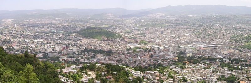
Tegucigalpa as viewed from El Picacho City Park. Source: Wikimedia Commons
Government
The 1982 constitution provides for a strong executive, a unicameral National Congress, and a judiciary appointed by the National Congress. The president is directly elected to a 4-year term by popular vote. The Congress also serves a 4-year term; congressional seats are assigned to the parties' candidates in proportion to the number of votes each party receives in the various departments. The judiciary includes a Supreme Court of Justice (one president and 14 magistrates chosen by Congress for a 7-year term), courts of appeal, and several courts of original jurisdiction--such as labor, tax, and criminal courts. For administrative purposes, Honduras is divided into 18 departments, with 298 mayors and municipal councils selected for 4-year terms. There are no congressional or municipal term limits, but the constitution restricts the president to one term.
Government Type: Democratic constitutional republic
Capitol: Tegucigulpa - population 1 million (2009)
Administrative divisions: 18 departments (departamentos, singular - departamento);
|
|

Independence Date: 15 September 1821 (from Spain)
Legal System: civil law system. Honduras accepts compulsory International Court of Justice (ICJ) jurisdiction with reservations; and accepts International criminal court (ICCt) jurisdiction.
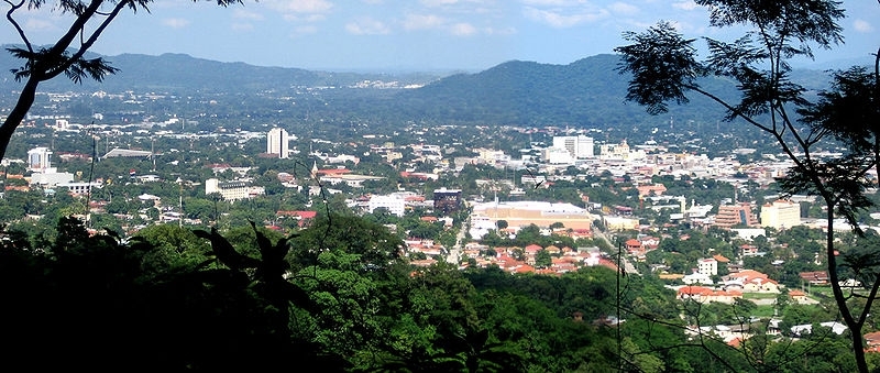
San Pedro Sula in northwestern Honduras. Source: Wikimedia Commons.
International Environmental Agreements
Honduras is party to Biodiversity, Climate Change, Climate Change-Kyoto Protocol, Desertification, Endangered Species, Hazardous Wastes, Law of the Sea, Marine Dumping, Ozone Layer Protection, Ship Pollution, Tropical Timber 83, Tropical Timber 94, Wetlands
Water
Total Renewable Water Resources: 95.9 cu km (2000)
Freshwater Withdrawal: 0.86 cu km/yr (8% domestic, 12% industrial, 80% agricultural)
Per Capita Freshwater Withdrawal: 119 cu m/yr (2000)
Access to improved drinking water sources: 86% of population
Access to improved sanitation facilities: 71% of population
Agriculture
Irrigated Land: 800 sq km (2008)
Products: bananas, coffee, citrus, corn, African palm; beef; timber; shrimp, tilapia, lobster
Economy
Honduras, with an estimated per capita gross domestic product (GDP) of $4,300 in 2011 (PPP), is one of the poorest countries in the western hemisphere, with about 65% of the population living in poverty. While 2010 estimates project GDP to have grown by 2.8%, Honduras’ GDP fell by 2.1% in 2009. Reasons for this contraction included the worldwide economic downturn and the political crisis surrounding the forced removal of President Zelaya from power. Previously, the economy grew by more than 6% per year from 2004 to 2007, and by 4% in 2008.
Historically dependent on exports of agricultural goods, the Honduran economy has diversified in recent decades and now has a strong export-processing (maquila) industry, primarily focused on assembling textile and apparel goods for re-export to the United States, as well as automobile wiring harnesses and similar products. Despite the recent economic diversification, there continues to be a large subsistence farming population with few economic opportunities. Honduras also has extensive forest, marine, and mineral resources, although widespread slash-and-burn agricultural methods and illegal logging continue to destroy Honduran forests.
Because of a strong commercial relationship with the United States, Honduras was hit hard by the international economic downturn, especially in the maquila industry, where orders were estimated to have declined about 40%, and where about 30,000 workers lost their jobs in 2008 and 2009 out of a pre-crisis workforce of 145,000. The maquila sector began to see an upswing toward the end of 2009 as the U.S. economy stabilized, and it has begun re-expanding its employment base. Over one-third of the Honduran workforce was considered either unemployed or underemployed in 2010.
Roughly 1 million Hondurans have migrated to the United States. Remittance inflows from Hondurans living abroad, mostly in the United States, are the largest source of foreign income and a major contributor to domestic demand. Remittances totaled $2.8 billion in 2009, down 11.8% from 2008 levels; that is equivalent to about one-fifth of Honduras’ GDP.
The US-Central America Free Trade Agreement (CAFTA) came into force in 2006 and has helped foster foreign direct investment, but physical and political insecurity, as well as crime and perceptions of corruption, may deter potential investors; about 70% of Foreign Direct Investment (FDI) is from US firms.
The economy registered sluggish economic growth in 2010, insufficient to improve living standards for the nearly 60% of the population in poverty.
The Lobo administration inherited a difficult fiscal position with off-budget debts accrued in previous administrations and government salaries nearly equivalent to tax collections. His government has displayed a commitment to improving tax collection and cutting expenditures, and attracting foreign investment. This enabled Tegucigalpa to secure an IMF Precautionary Stand-By agreement in October 2010. The IMF agreement has helped renew multilateral and bilateral donor confidence in Honduras following the Zelaya administration's economic mismanagement and the 2009 coup.
GDP: (Purchasing Power Parity): $35.6 billion (2011 est.)
GDP: (Official Exchange Rate): $17.3 billion (2011 est.)
GDP- per capita (PPP): $4,300 (2011 est.)
GDP- composition by sector:
agriculture: 12.6%
industry: 26.3%
services: 61.1% (2011 est.)
Industries: sugar, coffee, woven and knit apparel, wood products, cigars
Natural Resources: timber, gold, silver, copper, lead, zinc, iron ore, antimony, coal, fish, hydropower
Currency: lempiras (HNL)