Fortress of Fagaras
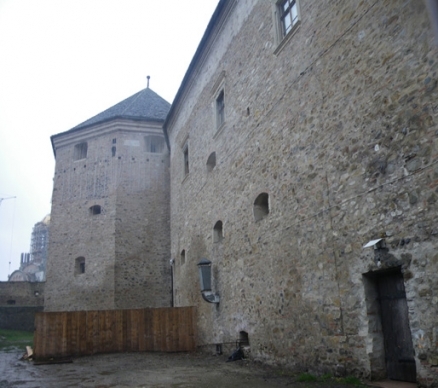
Eastern exterior facade of Fortress of Fagara. @ C.Michael Hogan
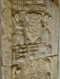 Medieval stone carving, Fagaras museum @ C.Michael Hogan
 The Fortress of Fagaras is the most noted monumental structure in Fagaras County, in the Transylvanian region of Romania (Ecoregions of Romania). Surrounded by a moat, the fortress sits not far from the south bank of the Olt River, the major watercourse draining the expansive Transylvania Plateau. This defensive structure has had predecessor architectural predecessors extending at least back through the Middle Ages; the entire Fagaras areas was a stronghold of Vlad Tepes, or Vlad the Impaler, the Romanian Prince who defended 15th century Romania from Ottoman invasion, and after whom the legendary Dracula figure was modeled. The fortress is notable not only because of its architectural splendour, but also due to its important position amid the environmental and governmental evolution of the Transylvanian Plateau during the second millennium AD. The massive fortress provided the regional military and civilian headquarters for the transformation of a feudal society to an advanced agricultural and cultural centre for this region by 1750 AD.
Contents
Geography and environment
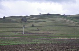 Undulating fields south of the Fortress of Fagaras. @ C.Michael Hogan
 The Fortress of Fagaras was established near thesouth bank of the Olt River, which watercoursemeanders on the Transylvania Plateau. This substantial river provided a plentiful water supply to medieval and earlier denizens of this local area. In addition the Olt discharges into Lake Victoria approximately 1.5 km west of the fortress, before emerging on the western side ofthat lake before continuingits journey southward to the Danube River.The Olt River has also been a historical source of fish to occupants of the fortress. Nearby local villages include Beclean to the west and Mandra to the east, both lying along National Highway 1. the base elevation of the fortress is approximately 550 metres above sea level.
Unlike the surrounding Carpathian Mountains, most of the native habitat of the entire Transylvania Plateau has been destroyed during the mid to late Holocene period due to the expansion of agriculture to feed the human population explosion; in fact, most of this habitat destruction and habitat fragmentation occurred subsequent to the mid thirteenth century, at which time the region was noted for expansive forests. beyond the loss of terrestrial habitat, water quality of the river Olt and lesser Transylvania Plateau watercourses has been degraded and continues to be adversely affected by intensive cropping practises and livestock grazing; moreover, other water pollution issues include nitrate (Nitrogen) loading from cropfertlisation and bacterial contamination from livestock access to streambeds, as well as discharge of considerable untreated sewage from settlements and villages along the upper and middle Olt River.
Founding through 16th century
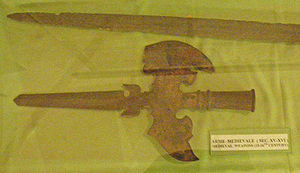 Medieval weapons from the Fagaras area on display at the Fortress. Source: C.Michael Hogan
 This part of Transylvania was known to be inhabitated by indigenous Dacians in the first century BC and continuing into the first century AD, toward the end of which Roman influence and conquest became apparent. Archaeologists have dated an original wooden fort on this site to at least as early as the 12th century AD.[1] this early version of the present fortress was surrounded by a perimeter ditch dug for defencive purposes; this wooden predecessor was ravaged and destroyed by fire in the middle 13th century. Notably the first recorded citation of Fagaras in the literature is within a volume known as the Andreanum, dated 1224; in this document Andrew II of Hungary gave certain lands south of Fogares (note the original spelling from the Andreanum document) all the way to the Danube River to the Teutonic Knights.[2] After the Tatar invasion in 1241-1242, Transylvanian Saxons settled in the area.In 1369, Louis I of Hungary presented the fortress and the whole of the Royal Estates of F?g?ra? to his vassal, Vladislav I of Wallachia, the entire territory remaining in the possession of Wallachian Princes until 1464. Except for this period of Wallachian rule, the fortess and town itself were the center of the surrounding royal estates belonging to the Hungarian kings.
Architecturally, the present masonry edifice was constructed beginning in the latter half of the 14th century with expansions continuing through the early 17th century.The original stone fortress was an irregular hexagon, which superfically resembled an irregular quadrangle having a single right angle.By the 15th century, the fortress of Fagaras has taken on its basic interior polygonal geometry that persits to the present day, being a fully enclosed hexagon of stone and brick, with four fortified towers, one at each principal (effectively quadrilinear) corner; furthermore, each of these four corner towers had been designed in the interesting form of a regular heptagon.A massive barbican tower enclosed the single gated intrance at the east. The earthen ditch was deepened with a slightly enlarged circumference in this period.
1600 to 1750
During the rule of Transylvanian Princes, Fagaras shone as an economic and social role model city in the southern regions of the Transylvanian realm. Between 1613 and 1629 Prince Gabriel Bethlen substantially added to the fortress, with addition of loggias in an arched design using masssive masonry pillars. He also created blockhouse bastions at each of the four principal corners of the fortress. the northeastern one having a prominent arrow shaped point. In this era a guardhouse was also constructed on the eastern side. During this period the circumferential ditch was flooded by creating a connection to the nearby Olt River.
In the next period 1631-1645, Prince Gheorghe Rakorzi I thickened the northern and southern interior walls by adding a secondary free-standing masonry wall and filling the massive void with earth; the resulting wall was approximately eight metres in thickness. The first half of the 17th century generally marked a transition of the fortress to a palatial residence, with augmentation of numerous buildings, especially features attached to the interior quadrangle; by 1676 the rooms numbered 85. Near the close of the 17th century the ground level of the fortress included culinary, storehouse and dungeon uses; level two held residences for the princesses, priests and prefects as well as captain and vice-captain; level three had designated spaces for the great hall, Prince's bedroom, long dining hall and certain other reception halls. Two smaller extensions of towers continued to levels four and five in the form of a summer house.
Beginning with the rule of the Transylvanian Princes, the Fort of F?g?ra? was the residence of the wives of Transylvanian Princes, as an analog of Veszprém, the Hungarian city of queens. Among these princesses, Zsuzsanna Lorántffy, widow of Rákóczy, founded a Vlach (Romanian) school here in 1658. The most notable of the princesses residing in the fortress was the orphan Princess Kata Bethlen (1700-1759).
Post World War II
Following World War II, the communists took over control of the entirety of Romania, backed by Soviet military strength. After that takeover the Fortress of F?g?ra? was used as a prison by the Communist State of Romania, specifically to imprision dissidents of the Communist State and other perceived enemies of communism. After the fall of the Communist State in 1989, the fortress has been restored and is currently used as a museum for local archaeological and historical artefacts as well as a folk costume museum and county library.
References
- .^ Gheorghe Dragota. 2009. The Fortress of Fagaras. The Museum of Fagaras county. ed. Florin Unguras
- ^ Istvan Vasary. 2006. Cumans and Tatars: Oriental military in the pre-Ottoman Balkans, 1185-1365 AD. 230 pages