Chad

Source: NASA
Countries and Regions of the World Collection  Chad is a landlocked nation of nearly eleven million people in northern-central Africa, south of Libya.
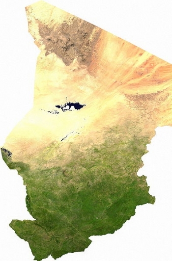
The country strectchs from the Sahara Desert in the north, through Selhel in its center, and savanna in the south. Lake Chad, in the west of the country, is the most significant water body in the Sahel.
Chad's major environmental issues incude:
|
|
|
|


- inadequate supplies of potable water;
- improper waste disposal in rural areas contributes to soil and water pollution; and,
- desertification.
It is susceptible to hot, dry, dusty harmattan winds in north; periodic droughts; and locust plagues.
Chad, part of France's African holdings until 1960, endured three decades of civil warfare as well as invasions by Libya before a semblance of peace was finally restored in 1990.
The government eventually drafted a democratic constitution, and held flawed presidential elections in 1996 and 2001.
In 1998, a rebellion broke out in northern Chad, which has sporadically flared up despite several peace agreements between the government and the rebels.
In 2005, new rebel groups emerged in western Sudan and made probing attacks into eastern Chad, despite signing peace agreements in December 2006 and October 2007.
In June 2005, President Idriss Deby held a referendum successfully removing constitutional term limits and won another controversial election in 2006.
Sporadic rebel campaigns continued throughout 2006 and 2007. The capital experienced a significant rebel threat in early 2008, but has had no significant rebel threats since then, in part due to Chad's 2010 rapprochement with Sudan, which previously used Chadian rebels as proxies.
Deby in 2011 was reelected to his fourth term in an election that international observers described as proceeding without incident.
Power remains in the hands of an ethnic minority.
Contents
Geography
Chad is a landlocked country in north central Africa, with a territory twice the size of Texas. Population densities range from 54 persons per square kilometer in southern zones to 0.1 persons in the vast northern desert region, itself larger than France. The population of the capital city of N'Djamena, situated at the confluence of the Chari and Logone Rivers, is representative of Chad’s ethnic and cultural diversity.
Chad has four bioclimatic zones. The northernmost Saharan Desert zone averages less than 200 mm (8") of rainfall annually. The central Sahelian zone receives between 200 and 600 mm (24") of rainfall and has vegetation ranging from grass/shrub steppe to thorny, open savanna. The southern zone, often referred to as the Sudanian zone, receives between 600 and 1,000 mm (39"), with woodland savanna and deciduous forests for vegetation. Rainfall in the small Guinea zone, limited to Chad's southwestern tip, ranges between 1,000 and 1,200 mm (47").
The country's topography is generally flat, with the elevation gradually rising as one moves north and east away from Lake Chad. The highest point in Chad is Emi Koussi, a mountain that rises 3,100 meters (10,200 ft.) in the northern Tibesti Mountains. The Ennedi Plateau and the Ouaddai highlands in the east complete the image of a gradually sloping basin, which descends toward Lake Chad. There also are central highlands in the Guera region rising to 1,500 meters (4,900 ft.).
Lake Chad, one of the most important wetlands on the continent and home to hundreds of species of fish and birds, shrank dramatically over 4 decades due to increased water use and inadequate rainfall. The lake, the second-largest in West Africa, covered 25,000 square kilometers in 1963 but had decreased to 1,350 square kilometers as of 2002. The Chari and Logone Rivers, both of which originate in the Central African Republic and flow northward, provide most of the water entering Lake Chad.
Location: Central Africa, south of Libya
Geographic Coordinates: 15 00 N, 19 00 E
Area: 1.284 million km2 (1,259,200 km2 land and 24,800 km2 water)
arable land: 2.8%
permanent crops: 0.02%
other: 97.18% (2005)
Land Boundaries: 5,968 km Border countries: Cameroon 1,094 km, Central African Republic 1,197 km, Libya 1,055 km, Niger 1,175 km, Nigeria 87 km, Sudan 1,360 km
Natural Hazards: hot, dry, dusty harmattan winds occur in north; periodic droughts; locust plagues
Terrain:Broad, arid plains in center, desert in north, mountains in northwest, lowlands in south. Its lowest point is the Djourab Depression (160 metres) and its highest point is Emi Koussi (3,415 metres)
Climate: Tropical in south, desert in north
|
Source: Wikimedia Commons |
Topography of Chad. Source: Wikimedia Commons |

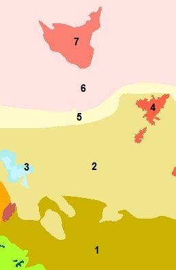
Ecology and Biodiversity
|
Ecoregions of Chad. Source: World Wildlife Fund |
|
|
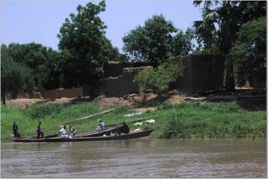
| Chari River. Source: Rebecca Musarra/Wikimedia Commons |
|
|
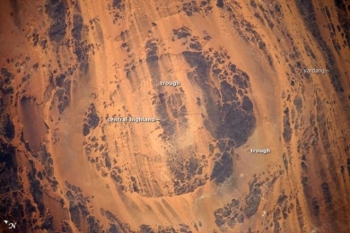
| Aorounga Impact Crater, located in the Sahara Desert of north-central Chad, is one of the best-preserved impact structures in the world. The crater is thought to be about 345-370 million years old, based on the age of the sedimentary rocks deformed by the impact. Radar data suggests that Aorounga is one of a set of three craters formed by the same impact event. The other two suggested impact structures are buried by sand deposits. Image courtesy of NASA. |
People and Society
Population: 10,975,648 (July 2012 est.)
There are more than 200 ethnic groups in Chad. Those in the north and center are generally Muslim; most southerners are Christians or animists. About 80% of the Chadian population is rural. There are over 250,000 refugees near the eastern border from the Sudanese conflict in Darfur; more than 60,000 Central African Republic refugees in the south; and approximately 130,000 internally displaced persons in eastern Chad.
Ethnic groups: Sara 27.7%, Arab 12.3%, Mayo-Kebbi 11.5%, Kanem-Bornou 9%, Ouaddai 8.7%, Hadjarai 6.7%, Tandjile 6.5%, Gorane 6.3%, Fitri-Batha 4.7%, other 6.4%, unknown 0.3% (1993 census)
Age Structure:
0-14 years: 46% (male 2,510,656/female 2,441,780)
15-64 years: 51% (male 2,531,896/female 2,960,406)
65 years and over: 2.9% (male 131,805/female 182,402) (2011 est.)
Population Growth Rate: 1.98% (2012 est.)
Birthrate: 38.7 births/1,000 population (2012 est.)
Death Rate: 15.16 deaths/1,000 population (July 2012 est.)
Net Migration Rate: -3.74 migrant(s)/1,000 population (2012 est.)
Life Expectancy at Birth: 48.69 years
male: 47.61 years
female: 49.82 years (2012 est.)
Total Fertility Rate: 4.93 children born/woman (2012 est.)
Languages: French (official), Arabic (official), Sara (in south), more than 120 different languages and dialects
Literacy: definition: age 15 and over can read and write French or Arabic
total population: 25.7%
male: 40.8%
female: 12.8% (2000 est.)
Urbanization: 28% of total population (2010) growing at an annual rate of change of 4.6% (2010-15 est.)
History
The region has been known to traders and geographers since the late Middle Ages. Since then, Chad has served as a crossroads for the Muslim peoples of the desert and sahelian regions, and the animist African tribes of the savanna regions to the south. While the former developed coherent political entities that became the powerful kingdoms of Kanem-Bornu, Baguirmi, and Ouaddai, controlling much of northern and central Chad as well as parts of Nigeria and Sudan, the southern regions were much less politically developed and remained splintered into small, local, tribal chiefdoms. Contact between the two regions was dominated by regular raids conducted by Muslims into the non-Muslim south to secure slaves for their own use and for trade into North Africa and the Middle East.
The French first entered Chad in 1891, establishing their authority through military expeditions that reduced the politically backward south and by defeating the armies of the northern and central Muslim kingdoms, culminating in decisive victory over the powerful kingdom of Baguirmi in the battle of Kousseri (today in Cameroon). The French did not consider the territory pacified until 1911; armed clashes between French forces and local resistance fighters continued for years thereafter.
France ruled southern Chad ("le Tchad Utile," or Useful Chad) as a typical colony with civil administration, basic education, urbanization of major centers, and missionary activity, while exploiting the region’s agricultural potential. The French ruled northern and central Chad ("le Tchad des Sultans," or Chad of the Sultans) differently, confining the colonial footprint to a few military garrisons and relying on traditional tribal and religious leaders to administer the local populations in time-tried ways. The French made Chad, along with what are today Gabon, the Central African Republic, and the Republic of the Congo, part of a colonial federation called French Equatorial Africa, under a governor-general resident at Brazzaville in what is now the Republic of the Congo.
In 1959, the territory of French Equatorial Africa was dissolved, and its four constituent states--Gabon, the Central African Republic, the Republic of the Congo, and Chad--became autonomous members of the French Community. In August 1960 Chad became an independent nation under its first president, Francois Tombalbaye, a southerner.
Tombalbaye's authoritarianism and distrust of democracy led him in 1962 to ban all political parties except his own Chadian Progressive Party (PPT) and to attempt to concentrate all power in his own hands. His treatment of opponents, real or imagined, was extremely harsh, filling the prisons with thousands of political prisoners. His discrimination against the mostly Muslim central and northern regions and his attempt to impose his own ethnic group’s customs on other tribes in Chad resulted in a tax revolt in 1965 that precipitated civil war with northern and central militants taking up arms to oust Tombalbaye and end the South’s political dominance.
Despite the help of French combat forces, the Tombalbaye government was never able to quell the insurgency. Tombalbaye's rule became more irrational and brutal, leading the military to carry out a coup in 1975, assassinating Tombalbaye and installing General Felix Malloum, another southerner, as head of state. In 1978, Malloum's government was broadened to include more northerners. Internal dissent within the government led the northern prime minister, Hissein Habre, to send his fighters against the national army in the capital in 1979, reigniting the civil war.
Nigeria and the Organization of African Unity (OAU) attempted to bring the Chadian factions together. In August 1979, the Lagos accord established a transitional government pending national elections planned within 18 months. Goukouni Oueddei, a northerner, was named President; Colonel Kamougue, a southerner, Vice President; and Habre, Minister of Defense. Early in 1980, however, the accord broke down and fighting broke out again between Goukouni's and Habre's partisans. With assistance from Libya (which asserted a claim to the northern Chadian territory called the Aouzou Strip), Goukouni regained control of the capital and other urban centers and Habre retreated into Sudan. Goukouni’s policy of political union of Chad and Libya, however, was unpopular and generated support for Habre, whose forces took N'Djamena in June 1981. He proclaimed himself President. French troops and an OAU peacekeeping force of 3,500 Nigerian, Senegalese, and Zairian troops remained neutral during the conflict.
Habre continued to face armed opposition on various fronts and brutally repressed opposition to his rule. In 1983, Goukouni’s forces launched an offensive against the Habre government’s positions in northern and eastern Chad with Libyan military support. This provoked French and Zairian forces to intervene to support Habre, pushing Goukouni’s and Libyan forces northward. In 1984, the French and Libyan Governments announced the mutual withdrawal of their forces from Chad. The French and Zairian troops withdrew, but Libyan forces backing Goukouni continued to occupy northern Chad.
Habre defeated southern rebel groups and began a process of national reconciliation with former armed enemies and regime opponents. In 1986, Habre’s forces, with French and U.S. financial and logistical support, attacked and decisively defeated the Libyans and Goukouni’s forces in northern Chad in what was known as the Toyota War, from Habre’s desert warriors’ preference for using light trucks and desert-warfare tactics in overcoming the more numerous and better-armed and -equipped enemy. With Libyan forces expelled from nearly all of Chadian territory, a cease-fire was declared in 1987 and Chad and Libya restored normal relations in 1989. In 1994 the International Court of Justice confirmed Chadian sovereignty over the Aouzou Strip, effectively ending residual Libyan occupation of parts of Chad.
Habre’s increasingly authoritarian rule and perceived favoritism of his own Gorane ethnic group weakened the coalition of northern and central groups on which he depended for support. In 1989, Idriss Deby, one of Habre's leading generals and a Zaghawa, defected and fled to Darfur in Sudan, from which he mounted a Zaghawa-supported series of attacks on the Habre regime. In December 1990, with Libyan and Sudanese assistance, Deby's forces successfully marched on N'Djamena, causing Habre to flee the country. Deby's Patriotic Salvation Movement (MPS) approved a national charter on February 28, 1991, with Deby as president.
During the 1990s and into the new century, Deby ruled in an authoritarian fashion, although proclaiming a desire for a democratic transition while surviving frequent coup and assassination attempts. He promulgated a new constitution in 1996, legalized political parties in 1992, and held an inclusive “National Conference” in 1993 aimed at political and electoral reform leading to a pluralist democratic regime.
In 1996, Deby won the country's first multi-party presidential election, defeating General Kamougue. In 1997, Deby’s MPS party won 63 of 125 seats in legislative elections. International observers noted numerous serious irregularities in both electoral events. In 2001, Deby won reelection in a flawed contest, gaining 63% of the votes. In 2002, the MPS was successful in similarly flawed legislative elections.
In 2004, the National Assembly voted to amend the constitution to abolish presidential term limits; the amendment was approved in a 2005 national referendum. In 2006, Deby was elected to his third 5-year presidential term with 78% of the vote.
As a result, opposition parties boycotted the 2006 National Assembly elections, precipitating a political crisis. The government responded by signing an agreement with the opposition coalition for a program of political and electoral reforms aimed at credible national legislative, municipal, and presidential elections, codified in an August 13, 2007 accord. The accord also extended the mandate of the 2002 Assembly until such time as the reforms were achieved and the elections held.
Dissatisfaction with Deby’s long rule among many ethnic groups, including subsets of Deby’s own Zaghawa ethnic group, and tensions between Chad and Sudan caused by the Darfur crisis led in 2004 to the creation of a renewed and serious rebel threat: several newly-formed Chadian rebel groups found refuge in Sudan and support from the Sudanese Government, enabling them to mount frequent armed attacks into Chad, with the intention of violently toppling the Deby regime. Deby’s situation was complicated by the influx of 300,000 Darfuri refugees into Chad and the displacement of 200,000 Chadians in eastern Chad. The Governments of Chad and Sudan soon became involved in a deadly proxy war, with the Government of Chad supporting Sudanese rebels committed to regime change in Khartoum and the Government of Sudan supporting Chadian rebels with the same goal vis-a-vis Chad. Sudanese rebels reached the Chadian capital twice, in 2006 and 2008, nearly overrunning the city in the latter instance, before being repulsed by government forces.
In 2008-2009, after the Chadian Army had defeated three major rebel attacks, and the Sudanese Army repulsed a rebel attack that reached the suburbs of Khartoum, international pressure for the normalization of Chad-Sudan relations intensified. Several Chad-Sudan agreements brokered by third parties had failed from 2006 to 2008, following which N’Djamena and Khartoum moved to resolve their differences bilaterally. This resulted in January 2010 in a Chad-Sudan peace accord, according to which the sides agreed to end the proxy war by breaking with rebel clients, normalize relations, and secure their border through joint military cooperation. President Deby publicly renounced past support for Sudanese rebels, a key Sudanese and international demand, and committed Chad to assist international efforts to resolve the Darfur crisis through peaceful negotiation.
The humanitarian effort to assist refugees and displaced persons in eastern Chad led to the deployment of two international peacekeeping operations, a European one from 2007-2008, and a UN one called MINURCAT, beginning in 2008. In 2010, the Government of Chad declined to agree to a renewal of MINURCAT's mandate, claiming that the project had been ineffective and proposing to provide better security with its own resources. MINURCAT ceased operations in December 2010. Chad provides security in and around refugee camps and to humanitarian personnel providing assistance through the Detachement Integre de Securite (DIS), a Chadian national police force created by the Chadian Government expressly for this purpose.
The August 13, 2007 accord on political and electoral reforms continues to be implemented. The accord has been facilitated through technical and political support from the European Union (EU), the U.S., France, Germany, the African Union (AU), and Switzerland, and they and the UN actively support the electoral process. In February 2011, Chad held legislative elections. Approximately 56% of the electorate voted, and the election was conducted without major incidents or any violence. On February 27, Chad’s electoral commission announced that the ruling MPS and its allies had won 133 of 188 National Assembly seats. Opposition leaders alleged that fraud and irregularities invalidated the elections, but Chad’s Constitutional Court did not nullify the results. International observers noted the lack of election preparation and some irregularities, but did not consider the government to have engaged in fraud.
Chad held presidential elections in April 2011. President Deby won easily, with approximately 88% of the vote, although turnout appeared low to international observers. Leading opposition figures boycotted the presidential elections due to concerns that deficiencies in the legislative elections had not been corrected. Municipal elections are scheduled for January 2012.
Government
The constitutional basis for the government is the 1996 constitution. A strong executive branch headed by the president dominates the Chadian political system. Chad is a unitary, centralized republic. The executive branch names all 22 governors, 61 prefects, and 252 sub-prefects, who have wide powers to administer the national territory.
The president has the power to appoint the prime minister and the Council of State (or cabinet), as well as judges, military officers, provincial officials, and heads of Chad's parastatal firms. In cases of grave and immediate threat, the president, in consultation with the National Assembly President and Council of State, may declare a state of emergency.
National Assembly deputies are elected by universal suffrage for 4-year terms. The Assembly holds regular sessions twice a year, and can hold special sessions when called for by the prime minister. Deputies elect a president of the National Assembly every 2 years. Assembly deputies or members of the executive branch may introduce legislation; once passed by the Assembly, the president must take action to either sign or reject the law within 15 days. The National Assembly must approve the prime minister's plan of government and may force the prime minister to resign through a majority vote of no confidence. However, if the National Assembly rejects the executive branch's program twice in 1 year, the president may disband the Assembly and call for new legislative elections. In practice, the president exercises considerable influence over the National Assembly through the MPS party structure.
Despite the constitution's guarantee of judicial independence from the executive branch, the president names most key judicial officials. The Supreme Court is made up of a chief justice, named by the president, and 15 councilors chosen by the president and National Assembly; appointments are for life. The Constitutional Council, with nine judges elected to 9-year terms, has the power to review all legislation, treaties and international agreements prior to their adoption. The constitution recognizes customary and traditional law in locales where it is long-established and to the extent it does not interfere with public order or constitutional guarantees of equality for all citizens.
|
Government Type: Republic Capital: N'Djamena - 808,000 (2009) Administrative Divisions: 22 regions (regions, singular - region);
Independence Date: 11 August 1960 (from France) Legal System: mixed legal system of civil and customary law. Chad has not submitted an International Court of Justice (ICJ) jurisdiction declaration; but accepts International Criminal Court (ICCt) jurisdiction. Suffrage: 18 years of age; universal |
Source: Wikimedia Commons |

International Environmental Agreements
Chad is party to international agreements on: Biodiversity, Climate Change, Desertification, Endangered Species, Hazardous Wastes, Ozone Layer Protection, and Wetlands. It has signed, but not ratified agreements of the Law of the Sea and Marine Dumping.
International Disputes
Since 2003, ad hoc armed militia groups and the Sudanese military have driven hundreds of thousands of Darfur residents into Chad.
Chad wishes to be a helpful mediator in resolving the Darfur conflict, and in 2010 established a joint border monitoring force with Sudan, which has helped to reduce cross-border banditry and violence.
Only Nigeria and Cameroon have heeded the Lake Chad Commission's admonition to ratify the delimitation treaty, which also includes the Chad-Niger and Niger-Nigeria boundaries.
Water
Total Renewable Water Resources: 43 cu km (1987)
Freshwater Withdrawal: total: 0.23 cu km/yr (17% domestic, industrial, 83% agricultural)
Per Capita Freshwater Withdrawal: 24 cu m/yr (2000)
Access to improved sources of drinking water: 50% of population
Access to improved sanitation facilities: 9% of population
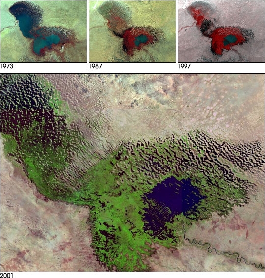
Lake Chad, once one of the African continent's largest bodies of fresh water, has dramatically decreased in size due to climate change and human demand for water. Once a great lake close in surface area to North America's Lake Erie, Lake Chad is now a ghost of its former self. According to a study by University of Wisconsin-Madison researchers, working with NASA's Earth Observing System program, the lake is now 1/20th of the size it was 35 years ago.
Found at the intersection of four different countries in West Africa (Chad, Niger, Nigeria, and Cameroon), Lake Chad has been the source of water for massive irrigation projects. In addition, the region has suffered from an increasingly dry climate, experiencing a significant decline in rainfall since the early 1960s.
The most dramatic decrease in the size of the lake is shown in the fifteen years between January 1973 and January 1987. Beginning in 1983 the amount of water used for irrigation began to increase. Ultimately, between 1983 and 1994, the amount of water diverted for purposes of irrigation quadrupled from the amount used in the previous 25 years. The red color denotes vegetation on the lake bed and the ripples on the western edge of the lake denote sand dunes formed by the wind.
The bottom picture is a composite of Landsat-7 images from November 2000 to February 2001 showing the present stage of Lake Chad. The small patch of blue that is now the lake stands in stark contrast to the wide swath of the old lake bed (shown in green, indicating vegetation).
Source: NASA. Images courtesy NASA GSFC Scientific Visualization Studio and Landsat 7 Project Science Office.
Agriculture
At least 80% of Chad's population relies on subsistence farming and livestock raising for its livelihood. Cotton, cattle, and gum arabic provide the bulk of Chad's non-oil export earnings.
Primary markets for Chadian non-petroleum exports include neighboring Cameroon and Nigeria and France, Germany, and Portugal. Cotton remains an important export. The national cotton company--CotonTchad--is planned for privatization. The parastatal has been poorly managed and cotton yields have been steadily declining over the past several years.
Agricultural Products: cotton, sorghum, millet, peanuts, rice, potatoes, manioc (tapioca); cattle, sheep, goats, camels
Irrigated Lands: 300 sq km (2003)
Resources
Natural Resources: petroleum, uranium, natron, kaolin, fish (Lake Chad), gold, limestone, sand and gravel, salt.
Energy
Since 2000, a consortium of three oil companies--U.S.-based Exxon Mobil and Chevron, joined by the Malaysian Petronas company--has been extracting oil from wells in the south of Chad and sending it to market via a pipeline from Chad through Cameroon to the Gulf of Guinea. The consortium has invested more than $7 billion in the Chad-Cameroon petroleum pipeline project, which originally had support from the World Bank in the form of Bank loans to Chad and Cameroon to enable them to participate in the project. In return, the Chad Government agreed to a set of unique mechanisms for World Bank, private sector, government, and civil society collaboration to guarantee that future oil revenues would benefit local populations and result in poverty alleviation.
Economically, the project has been extremely successful, rewarding both the consortium and the Chad Government with profits well beyond those initially expected by either one. Chad’s oil exports to the U.S. make it the sixth-leading African exporting country to the U.S. However, the poverty alleviation goals of the agreement were not met, due in part to Chad’s emphasis on defense expenditures rather than on socio-economic development per the agreement. The agreement was renegotiated in 2006, but the Bank did not judge that Chad’s performance under the second agreement was acceptable. Consequently, the Bank decided in 2008 to withdraw from the Chad petroleum sector and asked the Chad Government for early repayment of its loans. The Chad Government complied in 2009. The Bank and Chad continued to cooperate in sectors other than petroleum through 2010, when the World Bank sent a resident representative to Chad to broaden cooperation.
Chinese companies are also expanding exploration efforts and have completed a 311-km pipeline and the country's first refinery.
The nation's total oil reserves are estimated at 1.5 billion barrels. Oil production came on stream in late 2003. Chad began to export oil in 2004.
| Production | Consumption | Exports | Imports | Reserves | |
| Electricity | 100 million kWh (2008 est.) |
93 million kWh (2008 est.) |
0 kWh (2009 est.) |
0 kWh (2009 est.) |
|
| Oil | 126,200 bbl/day (2010 est.) |
2,000 bbl/day (2010 est.) |
115,000 bbl/day (2009 est.) |
1,837 bbl/day (2009 est.) |
1.5 billion bbl (1 January 2006 est.) |
| Natural Gas | 0 cu m (2009 est.) |
0 cu m (2009 est.) |
0 cu m (2009 est.) |
0 cu m (2009 est.) |
0 cu m (1 January 2011 est.) |
| Source: CIA Factbook | |||||
Economy
Chad's primarily agricultural economy will continue to be boosted by major foreign direct investment projects in the oil sector that began in 2000.
More than 80% of the work force is involved in agriculture--small-scale subsistence farming, herding, and fishing. Like other developing countries, Chad has a small formal sector and a large, thriving informal sector. In 2010, Chad's GDP was estimated at approximately $8.6 billion, distributed among agriculture, industry, and services. Chad is highly dependent on foreign assistance. Its principal donors include the European Union, France, and the multilateral lending agencies. Petroleum, cotton, cattle, and gum arabic are Chad's major exports.
Chad's economy has long been handicapped by its landlocked position, high energy costs, and a history of instability.
Chad relies on foreign assistance and foreign capital for most public and private sector investment projects.
Remittances are also an important source of income.
The Libyan conflict disrupted inflows of remittances to Chad's impoverished western region which relies on income from Chadians living in Libya.
A consortium led by two US companies has been investing $3.7 billion to develop oil reserves - estimated at 1.5 billion barrels - in southern Chad. Chinese companies are also expanding exploration efforts and have completed a 311-km pipeline and the country's first refinery. The nation's total oil reserves are estimated at 1.5 billion barrels. Oil production came on stream in late 2003. Chad began to export oil in 2004.
The other major export is livestock--cattle, sheep, goats, and, camels--driven to market or skins shipped to market in neighboring countries, particularly Nigeria. Chad also sells smoked and dried fish to its neighbors and exports several million dollars worth of gum arabic to Europe and the United States each year. Other food crops include millet, sorghum, peanuts, rice, sweet potatoes, manioc, cassava, and yams. Chad's economic performance outside the oil sector continues to depend on fluctuations in rainfall and in prices of its principal export commodities, especially cotton.
Public revenue management and corruption continue to plague Chad. The country reached a decision point in 2001 for Heavily Indebted Poor Countries (HIPC) debt relief and was receiving assistance from the International Monetary Fund (IMF) and World Bank. By 2002, however, the country needed an extension on the IMF Poverty Reduction and Growth Facility (PRGF) program's performance indicators. It continued to receive assistance from the international financial institutions but struggled to meet the program's financial targets, and the Fund ceased the program for non-performance. The IMF renewed Fund-managed programs with Chad in 2008 and 2009, but the country was unable to meet the targets and is not currently eligible to received IMF or HIPC assistance.
GDP (Purchasing Power Parity): $19.69 billion (2011 est.)
GDP (Official Exchange Rate): $9.6 billion (2011 est.)
GDP-per capita (PPP): $1,900 (2011 est.)
GDP-composition by sector:
agriculture: 52.7%
industry: 6.7%
services: 40.6% (2011 est.)
Population Below Poverty Line: 80% (2001 est.)
Industries: oil, cotton textiles, meatpacking, brewing, natron (sodium carbonate), soap, cigarettes, construction materials
Exports: oil, cattle, cotton, gum arabic
Export Partners: US 87.2%, Japan 3.6%, South Korea 2.8% (2006)
Imports: machinery and transportation equipment, industrial goods, foodstuffs, textiles
Import Partners: France 19.8%, Cameroon 15.7%, US 10.6%, China 9.2%, Germany 7.3%, Saudi Arabia 4.3% (2006)
Economic Aid Recipient: ODA, $379.8 million (2005)
Currency: Communaute Financiere Africaine franc (XAF)