Amur River
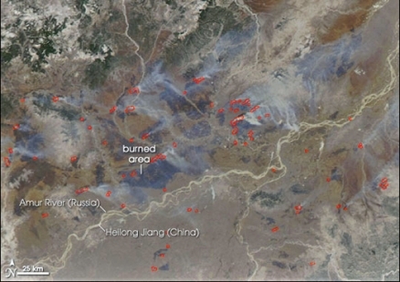
Amur River forming a portion of the Russia/China border. Source: NASA
The Amur River, considered the Earth's tenth largest watercourse, has its headwaters in western Manchuria and mouth at the Strait of Tartary, which connects the Sea of Japan with the Okhotsk Sea. Much of its length defines the border between Russia and China.
Although the generally level topography has made this basin vulnerable to heavy exploitation by agriculture, the region boasts many endemic species of fish, and its wetlands are important to a number of species of rare and endangered birds.
The Amur River became contaminated by a massive toxic release on the Chinese side of the catchment basin in 2005, which effects still linger to the current time. Similarly there are extensive deposits of mercury in Amur River sediments, residual from the central planning poor management practises of the communist Soviet era.
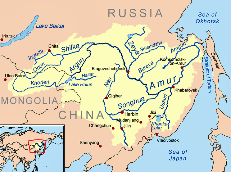 Map of the Amur River Basin. Source: K.Musser
Contents
Hydrology
The length of the Amur River is 2825 kilometers, a river that boasts a myriad of islands, notably in the locale of the Sungari River confluence. The drainage area of the Amur Basin amounts to approximately 1,855,000 square kilometers. Most of the flow occurs in the spring-summer floods driven by snowmelt and in the summer-autumn floods driven by monsoonal rains; winter is thus the low flow season within the basin Headwaters of the Amur River are formed by the confluence of the Argun and Shilka Rivers at an elevation of approximately 303 metres in western Manchuria. Thence the Amur flows generally eastward and forms a border between Russia and China in an immense southeast arc.
At Huma, the Amur is joined by a major tributary, the Huma River, after which point the Amur flows generally south. Subsequently the Zeya River merges its flow and adds appreciably to the volume and width of the Amur. The northwest part of the Zeya-Bureya Plain was formed at the lower reaches of these two major tributaries and the Amur mainstem.
In the discharge zone of the Strait of Tartary, seawater near Sakhalin Island has a notably low salinity, likely due to the Amur freshwater plume and the mixing zone currents within the strait. Satellite imagery reveals that the waters of the Amur carry a high sediment load from the river mouth, with elevated sediment loads being clearly visible as far north as the Bay of Sakhalin.
Water quality
The Amur River has experienced notable episodic water pollution events, particularly in the year 2005. Particular contaminants of concern include benzene, benzopyrene, nitrobenzene, anthracene and pyrene. The 2005 incident occurred as a massive pollutant release in the Songhua River in China, with major health risk impacts to the Russian city of Khabarovsk.
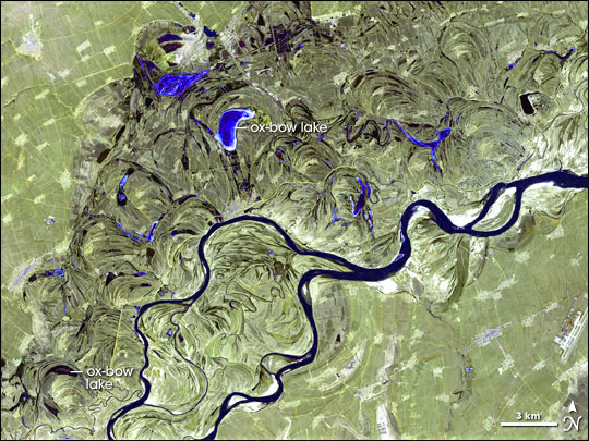 Songhua River braided channels and wetlands. Source: NASA
The persistence of mercury contamination in Amur River bottom sediments is a major issue, arising from historic cinnabar mining in the basin and poor waste management practises, especially in the communist Soviet era, where industrial development was placed ahead of sound conservation practises.
There is a notable undersaturation of carbon dioxide in the Okhotsk Sea, likely due to hyperactive photosynthetic activity in the Amur Estuary. Such a circumstance could be an attractive sink for carbon capture and storage projects needing a natural sink for CO2.
Notably elevated concentrations of silicon dioxide are present within the Amur Basin soils, particularly in Brunozem crust materials as well as silicon powder in floodplain and meadow steppe soils.
Aquatic biota
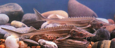 Amur sturgeon juveniles. Source: EOL/Chinese Academy of Fishery Sciences The largest native demersal [[fish] species] in the Amur River is the 560 centimeter (cm) long kaluga (Huso dauricus); demersal biota are those that inhabit the bottom of a surface water body. Another large demersal fish found in the Amur is the 300 cm Amur sturgeon (Acipenser schrenckii), a taxon which is endemic to the Amur basin. The green sturgeon (Acipenser medirostris) is a 250 cm demersal fish native to the Amur.
Other demersal endemic fish species (all in the concubitae family) of the Amur Basin are Iksookimia longicorpa, I. koreensis, I. hugowolfeldi, Cobitis melanoleuca melanoleuca and the Puan spine loach (Iksookimia pumila).
Carp family members that are endemic to the Ussuri River (a tributary of the Amur) and Lake Khanka are the small scale carp (Plagiognathops microlepis) and the black amur (Mylopharyngodon piceus). Carp species that are endemic to the Amur mainstem, Ussuri River and Lake Khanka are the black amur bream (Megalobrama terminalis) and Solitov's sheat-fish (Silurus soldatovi).
One of the large benthopelagic river fish of the Amur Basin is the 200 cmyellowcheek (Elopichthys bambusa); benthopelagic taxa are those living near the bottom of the river water column. The 122 cm Mongolian redfin (Chanodichthys mongolicus) and the 112 cm bighead carp (Hypophthalmichthys nobilis) are other large native benthopelagic fish found in the basin.
Terrestrial ecoregions

Amur River ecosystems. Source: World Wildlife Fund.
- Okhotsk-Manchurian taiga
- Ussuri broadleaf and mixed forests
- Trans-Baikal Bald Mountain tundra
- East Siberian taiga
- Da Hinggan-Dzhagdy Mountains conifer forests
- Manchurian mixed forests
- Amur meadow steppe
- Suiphun-Khanka meadows and forest meadows
- Changbai Mountains mixed forests
- Northeast China Plain deciduous forests
- Nenjiang River grassland
- Mongolian-Manchurian grassland
- Daurian forest steppe
- Trans-Baikal conifer forests
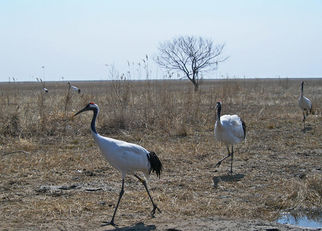 Migrating red-crowned cranes in the Songhua basin, tributary to the Amur. @ C.Michael Hogan
The Northeast China plain deciduous forests ecoregion comprises China's largest wetland; these marshy areas support many endangered species of birds including the red-crowned crane (Grus japonensis). The plains narrow between the Changbai Mountains to the east and grasslands to the west. Here, Mongolian oak (Quercus mongolica) is an important oak species with Daurian birch (Betula dahurica) and the shrubs bushclover (Lespedeza bicolor) and hazel (Corylus heterophylla). Deciduous forests dominate the plains along the Songhua River in this most extreme northeastern corner of China. More arid sites, such as south-facing slopes along with ruderal areas tend to support an association of Q. mongolica and Betula dahurica, while Acer spp. and Betula spp. thrive in wetter locations. Scrublands and the understory of drier more open forest stands support thorny shrubs such as Daurian buckthorn (Rhamnus dahuricus), hawthorn (Crataegus pinnatifida) and Daurian rose (Rosa dahurica).
The Amur meadow steppe covers a considerable amount of the middle reaches of the Amur Basin. This extensive meadow and wetland has resulted from the meandering of the Amur through the Amur-Heilong Valley over millennia. The most pristine wetlands are found at the Arkhara lowlands in the vicinity of the Bureya River mouth.
Part of the lower Amur Basin intersects the Ussuri-Wusili meadow and forest meadow ecoregion. The Bohai and Churgene civilizations may have caused the formation of fire tolerant meadows and Mongolian oak woodland communities. The valley was probably both a refuge and biogeographical corridor for many species during the late Pleistocene glaciation. This explains the very high level of species diversity and the presence of floral relicts. Rare and endangered animals include Siberian tiger, Far Eastern leopard. Many fish are endemic to Lake Khanka or the Ussuri, and Lake Khanka is an important site for migrating birds in eastern Asia. Certain globally rare cranes and ibises are resident here.
Prior to the emergence into the mouth taiga, the Amur River runs through a portion of the Ussuri mixed and broadleaf forests ecoregion.
The Okhotsk-Manchurian taiga is the ecoregion covering the lowest reach of the Amur River catchment. This taiga boreal forest represents the northernmost occurrences of Manchurian species.
Prehistory
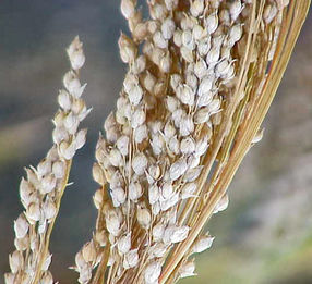 Proso millet, one of the first crops cultivated in the Amur Basin. Source: Kurt Stüber Human habitation in the Amur Basin has been analyzed and dated to at least as early as the Neolithic Period using the proxy of obsidian extraction and trading. The chief source of high quality volcanic obsidian has been validated by neutron activation and X-ray fluorescence. That extraction locus has been shown to be the Obluchie Plateau, located in the middle reach of the Amur River, supplyied the entire middle and lower parts of the Amur River basin during prehistory.
Obsidian derived from the Basaltic Plateau source, in the lower reach of the Amur (situated in the present day Primorye Province) was found to have been exploited in the Early Neolithic (13,000 to 9000 BC). At the Suchu Island site of the Early Neolithic (cf 6600 to 5200 BC), obsidian from the more distant site Shirataki (outside of the Amur Basin) on Hokkaido Island was established. It is noteworthy that obsidian trade was evident between Hokkaido and Sakhalin Islands (outside the Amur Basin) as early as 17,000 to 16,000 BC. Sedentary agriculture in the Amur Basin can be dated to as early as 2800 to 2600 BC based upon cultivation of Proso millet (Panicum miliaceum), foxtail millet (Setaria italica) and beefsteak plant (Perilla frutescens) in the Primorye.
Moreover, some of the earliest regional extraction of obsidian derived from Baekdu Mountain, slightly south of the Amur Basin. This source was deployed about 23,000 to 18,000 BC, implying that the Amur Basin was one of the last areas to be settled by humans in this portion of east Asia.
References
- Anastasiya Abrosimova. Igor Zhabin and Vyacheslav Dubina. 2008. Influence of Amur River discharge on hydrological conditions of the Amurskiy Liman and Sakhalin Bay of the Sea of Okhotsk during spring-summer flood. V.I.Il’ichev Pacific Oceanological Institute, Vladivostok, Russia
- Vladimir Nikolaevich Bashkin and Robert Warren Howarth. 2002. Modern biogeochemistry. Springer Publishing. 561 pages books.google.com
- Fishbase. 2010. Species in Amur
- Michael D.Glascocka, Yaroslav V.Kuzminb, Andrei V.Grebennikovc, Vladimir K.Popovc, Vitaly E.Medvedevd, Igor Y.Shewkomude, Nikolai N.Zaitsevf. 2011. Obsidian provenance for prehistoric complexes in the Amur River basin (Russian Far East). Journal of Archaeological Science Volume 38, Issue 8, August 2011, Pages 1832–1841
- N.A.Gvozdetskii and N. I. Michailov. 1978. Physical Geography of the USSR. Asian Part. Mysl, Moscow.
- F.S.Kot, K.G.Bakanov and N.A.Goryachev. 2010. Mercury in bottom sediments of the Amur River, its flood-plain lakes and estuary, Eastern Siberia. Environ Monit Assess. 168(1-4):133-40.
- V. B. Kozlovskii. 1978. Selected Features of the Water Dynamics in the Area of the Amur River Mouth, Tr. Gos. Okeanogr. Inst., No. 142, 93–99
- Yaroslav V.Kuzmin. 2008. Geoarchaeology of prehistoric cultural complexes in the Russian Far East: Recent progress and problems. Bulletin of the Indo-Pacific Prehistory Association
- N. I. Lobanova. 1987. General Characteristic of the Mixing Zone in the Amur River Mouth. Tr. DVNII, No. 130, 33–44 (1987).
- Kon-Kee Liu, Larry Atkinson and Renato Quiñones. 2010. Carbon and Nutrient Fluxes in Continental Margins: A Global Synthesis. 741 pages Google eBook
- M.A.Peschurof. 1858. Description of the Amur River in eastern Asia. Proceedings of the Royal Geographical Society of London: Volume 2. Royal Geographical Society (Great Britain) Google eBook
- Chittaranjan Ray and Mohamed Shamrukh. 2010. Riverbank Filtration for Water Security in Desert Countries. 303 pages. Springer Publishing. books.google.com