 Print book
 Print this chapter
GEOG101 Study Guide
Unit 5: Middle America
5a. Describe the differences between the rimland and the mainland of Middle America
- What are the characteristics that explain the division of Middle America into the rimland and mainland regions?
- How did the pattern of land use differ in these regions?
- How does the ethnicity of these two regions reflect their colonial history?
The division of Middle America into two regions based on location and physical geography is evident in the differing occupational activities and colonial dynamics of the rimland and the mainland. In terms of location, the names of the regions indicate their positions as shown in the map below. The differences in the physical geography of the two regions contributed significantly to the resulting patterns of land use.
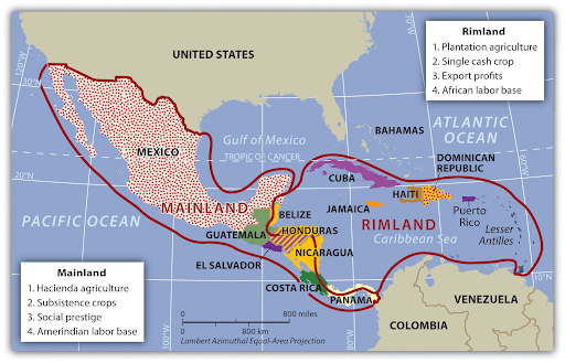
Colonists quickly took over the rimland islands and coastal areas, converting them to plantation agriculture. The origins of plantation agriculture are primarily northern European with the goal being efficiency. A single crop is grown for export on a large plot of land. The native AmerIndian population that survived the diseases the colonists brought provided labor during the harvest. Slaves were brought from Africa to provide the remaining labor, thus altering the ethnicity of many parts of the rimland. The rimland became a mix of primarily people of European and African descent.
It took longer for colonists to penetrate the larger mainland region. Because Spain colonized much of this region, they imposed the hacienda style of land use. This system provided the colonists with social prestige through land ownership rather than profits through exports. There was more crop diversity. The native AmerIndian population engaged in subsistence farming to survive. Slaves from Africa were uncommon, thus the ethnicity of the mainland became a mix of people of AmerIndian and European descent.
Review the section on Rimland and Mainland in the Introducing the Realm.
5b. Summarize the impact of European colonialism in Middle America
- What were the immediate effects of European colonists on the AmerIndians?
- What evidence is there of European colonialism in Middle America today?
European colonists had a devastating effect on the AmerIndians of Middle America. Within a hundred years, between 84 and 90 percent of the population had died due to disease, warfare, enslavement, and execution. The colonists were eager for immediate profit, looting precious metals and gems and seizing land. Many of the changes the colonists brought with them are evident today:
- the Spanish, French, Dutch, and English languages,
- the Christian religions, particularly Catholicism,
- domesticated animals,
- crops,
- building methods, and
- city planning.
Review:
- Introducing the Realm
- Central America: the section on European Colonialism
- The Caribbean: the section on European Colonialism in the Caribbean
5c. Distinguish between the Mayan and Aztec Empires
- Why is Mesoamerica considered one of the ancient cultural hearths of world civilization?
- What is the geographic extent of the Mesoamerican cultural hearth?
Mesoamerica is one of the places where civilization began. (The term Mesoamerica, meaning "middle America", is Greek but is reserved for identifying this region as it existed prior to the arrival of Europeans.) Because it was influential in creating customs, innovations, and ideologies, it is considered one of the world's ancient cultural hearths.
- The Olmec, Maya, Toltec, and Aztec civilizations, among others, all contributed to the development of this cultural hearth, which extended from central Mexico, including the Yucatán Peninsula, through the isthmus of Central America.
- The Maya predated the Aztecs. They made significant advancements in mathematics and astronomy, developing an accurate calendar. They also made remarkable contributions in architecture, engineering, and the development of the city-state. The Mayan Empire was centered on the Yucatán Peninsula extending west into the present-day Mexican provinces of Chiapas and Tabasco and east into present-day Belize, Guatemala, El Salvador, and Honduras.
- The Aztec Empire extended from southern Mexico into central Mexico, including present-day Mexico City. Mexico City is on the site of the Aztec city of Tenochtitlán, which was the largest and most sophisticated city in the Americas at the time. They conquered other groups, enforcing taxes and demanding respect through involuntary tributes. The Aztecs also made significant advances in agriculture and urban development.
The Aztec were in power when the Europeans arrived. Although the Europeans decimated the Aztecs and other AmerIndian groups, the evidence of the Mesoamerican civilizations remains in their descendents and their art and architecture.
Review Introducing the Realm.
5d. Describe Spanish influence in urban development across Middle America
- What activities dominated the center of Spanish cities?
- Where did the working poor live in the Spanish colonial city?
In Tenochtitlán, temples, palaces, and public buildings dominated the city center and economic activities occurred on the periphery. The Spanish model places the plaza or marketplace in the center.
- The plaza's boundaries are the church, government buildings, residences for the wealthy, and permanent stores.
- This perimeter and the plaza it surrounds constitute the city's core.
- As the distance from the core increases, the income of each residential zone decreases.
- Thus, Spanish cities grow by adding more concentric rings. As more rings are added, there are fewer city services available. The poorest city residents live in the outermost ring, known as barrios, where there are no city services.
The commoners in Aztec society also lived on the urban periphery due to the fact that many were engaged in agricultural activity.
Review Introducing the Realm.
5e. Describe the physical geography of Mexico, identifying the core and peripheral areas
- Why does Mexico have so many different climates?
- What physical features contribute to Mexico's ranking as the fourth most biodiverse country in the world?
- What features characterize Mexico's core and southern peripheral region but not its northern peripheral region?
As the eighth largest country in the world, it is not surprising that Mexico's physical geography would vary.
- The Tropic of Cancer (23.5° N) divides Mexico into two large climatic zones, and its topography divides those into even smaller zones.
- The fact that Mexico's land mass is larger to the north contributes to the effect of continentality away from the coastal areas.
- Mexico's varied topography means that temperatures will be cooler in the mountains and warmer in the valleys and along the coastal plains.
- Mexico's location makes it vulnerable to hurricanes along both its Pacific and Gulf of Mexico coasts.
- Like the United States, Mexico's west coast is the active edge of the North American Plate, resulting in earthquake and volcanic activity.
- Mexico's volcanoes are found in its core and southern peripheral region rather than its northern peripheral region.
Mexico's varied physical geography makes it home to ten to twelve percent of the world's species.
Review:
- Introducing the Realm: the Physical Geography section
- Mexico
5f. Outline the socioeconomic classes in Mexico and explain the ethnic differences of each
- Why is Mexico's social structure shaped like a triangle?
- What is ethnic breakdown of Mexico's population by percentage?
The following figure illustrates all of Middle America's social structure, including the ethnic groups that comprise each socioeconomic class. Mexico's social structure is also a triangle. Europeans make up nine percent of the total population yet control most of the wealth. Although mestizos make up sixty percent of the total population, not all of them have made it to the middle-class. Many of them join the AmerIndians, who make up about thirty percent of Mexico's population, in the labor base at the bottom.

Review the section on Mexican Social Order in Mexico.
5g. Explain how the North American Free Trade Agreement (NAFTA) and maquiladoras have influenced economic and employment situations in Mexico
- What was the purpose of NAFTA?
- What are maquiladoras?
The North American Free Trade Agreement (NAFTA) was a treaty between Canada, Mexico, and the United States that was in place from 1994 to 2020. The purpose of NAFTA was to reduce barriers to trade and investment between the three countries and has been beneficial to their respective economies. There have, however, been concerns that the economic growth has favored only some segments of society and that the environment and employment have suffered in some regions.
NAFTA led the United States to build manufacturing plants known as maquiladoras across the border in Mexico to take advantage of cheaper labor. Although maquiladoras provide jobs for Mexicans and cheaper goods to U.S. residents, there are disadvantages to both the workers and the environment. Maquiladoras exploit workers because Mexico's labor laws do not protect them from working longer hours with few benefits. Furthermore, housing and infrastructure are inadequate, causing extensive slum areas to grow around the maquiladoras.
Review the section on NAFTA and Maquiladoras in Mexico.
5h. Describe how the physical environment has affected human activity in Central America
- What is the dominant physical landscape in Central America?
- Explain altitudinal zonation.
Mountain ranges, lowlands, and coastal plains characterize the physical landscape of Central America, with mountainous terrain being the most prevalent. Because of the ubiquity of mountain ecosystems, the residents of Central America have adapted their activities based on altitudinal zonation as shown in the following figure. Thus, different crops are grown at different elevations.

Review:
- Introducing the Realm: the Physical Geography section
- Central America
5i. Discuss how the United States has affected Middle America
- What interests does the United States have in countries such as Guatemala and El Salvador?
- What is the geographic significance of Panama?
- Why did the United States become involved in Nicaragua?
- What Central American countries signed CAFTA?
The United States' economic and political interests have long affected countries in Middle America.
- The United States overthrew Guatemala's government because its social reforms conflicted with the highly profitable U.S. business United Fruit Company (UFC), now Chiquita Brands International.
- The U.S. also interfered in El Salvador's government to protect its coffee interests. The U.S. supported the wealthy landowners over the peasants who worked that land.
- The United States became involved in Nicaragua in the 1980s when the Sandinista National Liberation Front, a socialist political party, took power. The U.S. supported the Contras in their efforts to bring down the Sandinista government.
- The United States sought to shorten the shipping distance between New York and California so it took over the Panama Canal project from the French in the early twentieth century. The construction of the canal had an environmental impact and changed the cultural landscape of the area. Turning over control of the Panama Canal to Panama proved to be a political rather than an operational issue.
Although U.S. involvement in Central America has been destructive, it has contributed to the economies of some Central American countries.
- Costa Rica is a popular tourist destination for U.S. residents.
- The U.S. has joined Costa Rica, El Salvador, Guatemala, and Honduras in the Central America Free Trade Agreement (CAFTA), which seeks to create new and improve existing economic opportunities by reducing tariffs and opening markets, among other benefits.
- The Dominican Republic joined CAFTA in 2004, so it is now known as CAFTA-DR.
Review the section on The Republics: Diverse Political Geography in Central America.
5j. Compare and contrast the Central American republics
- Which Central American country's lingua franca is English?
- Why does Costa Rica have the nickname the Switzerland of Central America?
- Why do Belize and Panama have higher percentages of people of African descent?
- What have been the barriers to progress for many Central American countries?
Although these countries are similar in terms of their physical landscapes and colonial history, their cultural, political, and economic landscapes vary.
- As the only Central American country colonized by the British, Belize's lingua franca is English. Spain colonized the other Central American countries.
- Like Switzerland in Europe, Costa Rica is considered politically and economically stable compared to the other countries in the region. Multinational companies move here to take advantage of the stability, relatively low labor costs, and supportive environment for their employees.
- The British brought slaves from west Africa to work in what is now Belize. The U.S. imported laborers of African descent from the Caribbean to work on the Panama Canal.
- Guatemala, El Salvador, Honduras, and Nicaragua have all found political, economic, and social stability hard to come by due to corruption and gang violence, among other challenges.
In addition to these examples, there are many more similarities and differences between the seven republics of Central America.
Review Central America.
5k. Explain the reasons for constructing the Panama Canal
- Prior to completion of the Panama Canal, what route did ships have to take to travel between the Pacific and Atlantic Oceans?
- What was the impact of the Panama Canal on trade between the United States and the rest of the world?
Before construction of the Panama Canal, ships had to travel 12,000 miles to reach New York from San Francisco. Rather than traveling around the southern tip of South America, the Panama Canal made it possible to shorten the trip to 4,000 miles. In addition to easing the transportation of commercial cargo from one coast to the other, the Panama Canal also facilitated international relations with countries in the Pacific. The Panama Canal opened a new corridor between the East and West.
Review the section on Panama and the Panama Canal in Central America.
5l. Describe the effect of colonialism in the Caribbean
- In addition to Spain, what other European countries colonized the Caribbean?
- What is the current ethnic makeup of the Caribbean countries?
The effect of colonialism on the Caribbean countries differs somewhat from the other countries in Middle America. In addition to Spain, Great Britain, the Netherlands, France, and the United States colonized the islands of the Caribbean. Sweden, Belgium, Denmark, and Portugal also had a colonial influence. On some islands, there is still an active colonial presence as is the case in the U.S. territory of Puerto Rico, for example. The language of the colonists is still spoken in many Caribbean countries. Haiti, as a former French colony, has two official languages, French and Haitian Creole.
The ethnic makeup of the Caribbean countries also varies more than Mexico and most of the countries of Central America. Although the effect on the indigenous populations was the same, decimation through disease and subjugation, the African and Asian influence is greater. The colonists of these countries were more likely to import slaves from west Africa to labor in the plantations. When slavery was outlawed, colonists brought indentured laborers from their colonies in Asia. The British, for example, brought laborers from India to work in Trinidad. Rather than returning to their home countries, these indentured laborers stayed, contributing to the multiethnic heritage of the Caribbean.
Review the section on European Colonialism in the Caribbean in The Caribbean.
5m. List some genres of music that emerged from the Caribbean
- What influences are evident in the genres of Caribbean music?
- What explains the variety of genres coming from the rimland of Middle America?
The rimland of Middle America consists primarily of islands thus facilitating the development of different genres of music. Because the native populations of the islands were decimated due to disease brought by colonists and harsh treatment, little if any remnants of native musical traditions remain. Thus, each island's music evolved according to the origins of the people that settled there either by choice or enslavement. Cuba's music, for example, is a product of the cultures of its African slaves, Spanish colonists, and even Chinese immigrants brought to work in the sugar fields during the 19th century.
Review the section on Caribbean Music in The Caribbean.
5n. Explain how, why, and where hurricanes form
- What conditions result in hurricanes?
- Why is Middle America vulnerable to hurricanes?
Hurricanes begin formation over ocean waters that exceed 80°F and 160 feet in depth.
- The water warms the air above it, causing it to rise and creating an area of low pressure.
- Cooler air is drawn into the area of low pressure, replacing the rising air.
- The rising moisture-laden air begins to cool with altitude, forming clouds.
- This cycle continues as cloud cover increases and thunderstorms develop.
- Because the Earth rotates, so do these storm systems.
- When rotating wind speeds reach 39 mph, the storm is designated a tropical storm. When they reach 74 mph, it is designated a hurricane.
Hurricanes that form north of the Equator, like those affecting Middle America, rotate counterclockwise. Middle America is in the hurricane belt with the rimland and east coast of the mainland vulnerable to hurricanes that develop over the Atlantic and the west coast of the mainland vulnerable to hurricanes that develop over the Pacific.
Review:
5o. Describe the potential danger of hurricanes
- Why do hurricanes cause storm surge?
- What happens when hurricanes make landfall?
- How do hurricanes affect tourism in the Caribbean?
The force of hurricane winds moving cyclonically around a storm causes water to be pushed up in the center, creating a storm surge. As the storm moves toward shore, it encounters the continental shelf causing that storm surge to be pushed even higher. Storm surge is often the greatest threat from hurricanes due to the devastating impact on life and property. When the hurricane makes landfall, the storm begins to weaken but not without causing extensive damage from high winds, heavy rainfall, and extensive flooding. Although Caribbean cruises still operate during hurricane season, they do have contingency plans in place and encourage travelers to be flexible when scheduling their trips.
Review:
Unit 5 Vocabulary
This vocabulary list includes terms that students need to know to successfully complete the final exam for the course.
- African
- altitudinal zonation
- AmerIndian
- Aztec
- barrios
- Belize
- Caribbean
- Central American Free Trade Agreement (CAFTA)
- CAFTA-DR
- Chiquita Brands International
- city-state
- Coasta Rica
- concentric rings
- Contras
- cultural hearths
- Dominican Republic
- El Salvadore
- European
- Guatamala
- hacienda
- Haiti
- Honduras
- hurricanes
- hurricane belt
- indentured laborers
- isthmus
- lingua franca
- Maya
- mainland
- maquiladoras
- Mesoamerica
- mestizos
- Middle America
- mountain ecosystems
- multiethnic
- Nicaragua
- North American Free Trade Agreement (NAFTA)
- Olmec
- Panama Canal
- periphery
- plantation agriculture
- plaza
- Puerto Rico
- republics
- rimland
- Sandinista National Liberation Front
- socioeconomic class
- species
- storm surge
- subjugation
- Tenochtitlán
- Toltec
- topography
- trade winds
- Tropic of Cancer
- United Fruit Company (UFC)
- urban development
- Yucatán Peninsula