 Print book
GEOG101 Study Guide
| Site: | Saylor Academy |
| Course: | GEOG101: World Regional Geography |
| Book: | GEOG101 Study Guide |
| Printed by: | Guest user |
| Date: | Friday, February 4, 2022, 11:48 AM |
Description
Table of contents
- Navigating this Study Guide
- Unit 1: Introduction to Geography
- Unit 2: Europe
- Unit 3: Russia
- Unit 4: North America
- Unit 5: Middle America
- Unit 6: South America
- Unit 7: Sub-Saharan Africa
- Unit 8: North Africa and Southwest Asia
- Unit 9: South Asia
- Unit 10: East Asia
- Unit 11: Southeast Asia
- Unit 12: Australia and New Zealand
- Unit 13: The Pacific and Antarctica
Navigating this Study Guide
Study Guide Structure
In this study guide, the sections in each unit (1a., 1b., etc.) are the learning outcomes of that unit.
Beneath each learning outcome are:
- questions for you to answer independently;
- a brief summary of the learning outcome topic;
- and resources related to the learning outcome.
At the end of each unit, there is also a list of suggested vocabulary words.
How to Use this Study Guide
- Review the entire course by reading the learning outcome summaries and suggested resources.
- Test your understanding of the course information by answering questions related to each unit learning outcome and defining and memorizing the vocabulary words at the end of each unit.
By clicking on the gear button on the top right of the screen, you can print the study guide. Then you can make notes, highlight, and underline as you work.
Through reviewing and completing the study guide, you should gain a deeper understanding of each learning outcome in the course and be better prepared for the final exam!
Unit 1: Introduction to Geography
1a. Discuss the two main branches of geography
- What is the main focus of both physical and human geographers?
- Differentiate between physical geography and human geography by considering how a physical geographer might study Yellowstone National Park compared to a human geographer.
- How do physical and cultural landscapes differ?
Geography is a broad discipline that focuses on spatial relationships and the interaction between humans and their physical environment. Some geographers focus on spatial relationships in the human realm and others focus on them in the physical realm. In Maps Show Us Who We Are, Not Just Where We Are, Danny Dorling describes himself as a human geographer because he studies the relationship between humans and the Earth's surface. He uses maps to show cultural landscapes, those landscapes humans have altered or created such as trade routes, light pollution, and where rice, maize, and corn grow.
A physical geographer, on the other hand, considers the physical landscape. A physical geographer might look at Dorling's map of annual precipitation on Earth and want to explain the physical features that result in such a pattern. For example, the location of mountain ranges, the distance inland from the coast, and the pattern of ocean currents, among many other factors help to explain why annual precipitation differs from one place to another. Like human geographers, physical geographers study and compare places but their focus is on the non-human aspects such as rivers, landforms, climate, and plants.
Review:
- Maps Show Us Who We Are, Not Just Where We Are: a video showing the work of a human geographer
- Geography Basics: focus on the terms associated with physical and human geography
1b. Examine the tools that geographers use to study the Earth
- How do geographers use the Global Positioning System (GPS)?
- How does remotely sensed imagery enhance a geographer's study of a place beyond traditional maps?
- What are the advantages of geospatial technology to geographers?
- What role do maps play in Geographic Information Systems (GIS)?
Geographers have many tools at their disposal to help them study places and the relationships between those places. Many other disciplines use these tools, too and many people know much more about these tools than they think.
- Cell phones, for example, use the Global Navigation Satellite System (GNSS), including the Global Positioning System (GPS), the American segment of GNSS, to provide location information that aids navigation in unknown places.
- Remotely sensed imagery captured from satellites, aircraft, and drones, among other platforms, provide information about land use and land cover, which aids in hazard mitigation, for example. Much of this imagery has been and continues to be captured over time, providing a valuable temporal perspective on landscape change.
- Geographers, among others, use Geographic Information Systems (GIS) to put layers of data together, including remotely sensed imagery and GPS locations, to study a variety of phenomena. Maps are the most common mode of analysis and presentation, which is what distinguishes GIS from other modes of information science.
Whether a user examines a map as multiple geographic layers on a computer monitor or prints it out as a paper map, the ability to analyze data spatially is a powerful perspective.
Review:
- Introduction to Geospatial Science and Technology
- Geography Basics: focus on the tools that geographers use to study spatial relationships
1c. Explain the geographic grid and how it relates to time zones
- How would someone communicate the relative location and absolute location of Yellowstone National Park?
- How do geographers and cartographers use a graticule to organize locations?
- What is the relationship between climate and latitude?
- What is the relationship between time and longitude?
People can communicate their location in both absolute and relative terms. Creating a map for someone to use to drive from Quanzhou to Xiamen requires the absolute location of each city. If, however, someone from Xiamen is trying to provide a general idea of its location, the relative location may be sufficient and more helpful. Telling someone it is about 100 km southwest is easier to visualize than 24.48° N, 118.09° E.
Absolute locations such as the latitude and longitude for Xiamen are derived from a grid or graticule superimposed on the Earth. Latitude and longitude are angular measurements and, therefore, are measured in degrees. Latitude is measured north and south from the Equator (0°).
The Earth's circumference is longest at the equator so it is a natural starting point. Note the key lines of latitude below. The Earth's axial tilt means there are variations in the angle of direct sunlight as Earth rotates around the Sun. For example, the places along the Tropic of Capricorn are the southernmost places receiving direct sunlight during the Southern Hemisphere's summer. Places south of 23.5° S receive no direct sunlight during that season. Latitudinal location also contributes to the amount of seasonal variation.

Determining longitude has, historically, been more challenging than latitude. Unlike latitude, longitude does not have an obvious starting line, thus one had to be selected.
- Because Earth is a sphere, it can be divided into 360° of longitude.
- Most countries have agreed to use the Royal Observatory Greenwich in London, England as the starting line, 0°, which is known as the prime meridian.
- Longitude is measured 180° east and west of the Prime Meridian, which is the International Date Line (IDL) is 180°.
- It takes 24 hours for Earth to rotate 360° so one hour equals 1/24th of a rotation or 15° of longitude.
- Time zones are based on longitude as shown below.
- The time zone that extends from 67.5° W to 82.5° E with a central meridian of 75°E is the Eastern Standard Time Zone, including Colombia, Peru, and parts of Canada, the United States, and Ecuador, among others.
- To avoid dividing populated places, some time zone boundaries deviate to accommodate them. China has gone so far as to use one time zone for the entire country as a strategy for unifying its vast expanse rather than dividing it as the United States and Canada have done. Russia's hemispheric extent makes that impractical. If all of Russia used Moscow's time zone, for example, it would be dark in Vladivostok at noon.

Review:
1d. Discuss the spatial nature of geography and how each place or region is examined, analyzed, and compared
- Explain the concepts of realm and region.
- Provide examples of the three types of regions: formal, functional, and vernacular.
- Why do geographers use regions and/or realms?
Just as humans have a need to categorize to make sense of complexity, so, too, do geographers use categories to reduce the complexity of the world. Some geographers reduce this complexity into categories called regions.
- Generally, each region has one or more features in common. For example, in the United States, some people may refer to the relatively flat interior as the Midwest region.
- Clearly, not everyone agrees on the boundaries of the Midwest region because others may think agricultural production or tornado activity help define it. Regions based on perceptions like these are vernacular regions.
- There are regions that have boundaries that are not open to debate such as the boundary of Bolivia. Bolivia is a country with internationally recognized boundaries and is, therefore, a formal region.
- In between these two types of regions are functional regions, regions that coincide with a particular function or service that is offered. The delivery area of a grocery store is a functional region. People living within that functional region can have their groceries delivered. Those living outside that delivery area have to pick their purchases up at the store.
Geographers also work with regions that are substantially larger. This course, for example, introduces the discipline of geography through an exploration of the world.
- It is not practical to explore each location on the Earth's surface so those locations are sorted into regions according to their physical and cultural characteristics. These world regions are also called realms.
- Not everyone agrees on the specifics of what the world's regions are or what their boundaries should be. Thus, it is not uncommon to find some variation across courses, subdisciplines, and individuals.
- For the purpose of this course, the world is divided into thirteen realms that resemble the eleven realms shown below. Each realm is introduced in terms of its physical and human geography.
Although there is variation within each of regions of all sizes and overlap at the borders, there are many common characteristics that render each a coherent unit.

Review Geography Basics, the spatial nature of geography and the concept of the region.
1e. Examine and discuss some of the foundational concepts of geography: physical geography (including climate, geology, and biogeography); population geography; cultural geography (including culture, ethnicity, religion, and language); economic geography; and globalization
- How do climate, plate tectonics, and land cover such as forests relate to patterns of human habitation?
- What are the anthropogenic contributors to climate change, biodiversity loss, and environmental destruction?
- Why are human geographers uniquely qualified to study the process of globalization?
- What aspects of population structure have contributed to the demographic transition, urbanization, neocolonialism, and economic development?
The landscape features physical geographers study include climate, plate tectonics, and plant life, among many other facets of the environment.
- Their interest in climate includes the categorization of long-term average weather patterns into climate types, which help explain why humans living in arid climates face different challenges than those living in equatorial climate types, for example.
- Physical geographers are also interested in what natural processes produce these climate types. For example, the rain shadow effect explains the arid conditions where mountain ranges prevent moisture-land air from reaching their leeward sides.
- The tectonic activity that produces these mountain ranges and other geomorphic features is another research focus of physical geographers. A map of tectonic plates illustrates that mountain ranges often occur where two plates are converging.
In addition to the effect of the physical landscape on humans, humans have an effect on the physical landscape. When humans burn fossil fuels, for example, they emit greenhouse gases into the atmosphere, contributing to climate change. Humans also decrease biodiversity when they remove land cover such as forests. Because trees remove carbon dioxide, a greenhouse gas, from the atmosphere, their loss further contributes to climate change. Deforestation also increases the vulnerability of the area to landslides.
The landscape human geographers study includes its population, cultural and economic features, and patterns of globalization, among others. Not only has the distribution of humans changed over time, it has changed over space.
- Population geographers explore the spatial and temporal components of changes in population structure, including fertility rates, family size, and why some parts of the world are experiencing demographic transitions and others are not.
- Cultural geographers explore the attributes of populations beyond those that population geographers measure statistically. They focus on the interaction between human social behavior expressed through language, religion, art, and music, among other characteristics, and the natural landscape.
- Economic geographers study the spatial variation in the activities associated with human production and consumption including, for example, the economic development index, national income, national debt, budget deficits, urbanization, and brain drain of countries.
A geographic perspective is clearly critical to the understanding of globalization and its many facets. Indeed, many of the phenomena associated with the international spread of influence are, by definition, spatial: rural-to-urban shift, core-periphery, hinterland, and New World Order.
Review:
- Rainshadow Effect, Adiabatic Process, and Relative Humidity: examples of why physical geographers are interested in climate, climate change, plate tectonics, and related processes.
- Geography Basics
- The Environment and Human Activity
- Population and Culture
- Globalization and Development: The section with examples of topics that physical geographers find interesting.
Unit 1 Vocabulary
This vocabulary list includes terms that students need to know to successfully complete the final exam for the course.
- absolute location
- axial tilt
- climate types
- cultural landscapes
- cultural geographers
- deforestation
- economic geographers
- Equator
- formal region
- functional regions
- Geographic Information Systems (GIS)
- geography
- globalization
- Global Navigation Satellite System (GNSS)
- Global Positioning System (GPS)
- graticule
- human geographer
- International Date Line (IDL)
- landslides
- latitude
- longitude
- physical geographer
- physical landscape
- population geographers
- prime meridian
- rain shadow effect
- regions
- realms
- relative location
- remotely sensed imagery
- spatial relationships
- tectonic plates
- temporal perspective
- time zone
- Tropic of Capricorn
- vernacular regions
Unit 2: Europe
2a. Describe the climate types and physical landforms of the European continent
- Why do some parts of Europe have moderate climates even though it is a northern continent?
- How have Europe's rivers and mountain ranges shaped its cultural and economic landscape?
- Explain the factors that influence the location of Europe's major agricultural operations.
- Explain how Europe's geography yielded an abundance of biodiversity and contributed to its decline.
As a world region, Europe is relatively small. Its physical geography, however, ranges from places below sea level such as the Zuider Zee in the Northern Lowlands to Mont Blanc in the High Alps. The Northern Lowlands support much of Europe's agricultural activity. The Alpine region has served as a barrier to movement and as a contributor to the more temperate type C climate of the Mediterranean region. The ocean, particularly the Gulf Stream, makes these temperate regions of Europe possible. The farther one travels away from the coastlines, however, the less temperate the climate becomes. Thus, winters in Warsaw are much colder than those in Amsterdam even though they are both at about 52° N.
Although rivers, such as the Rhine and the Danube, have separated places, they also connect them. Europe has long depended on these rivers as trade routes. Europe also depends on natural resources and raw materials that its physical geography provides. Retrieving and using these materials has, however, contributed to biodiversity loss and environmental damage in Europe. Burning fossil fuels, for example, has caused air pollution and acid rain resulting in damage to forests including the Black Forest in southwest Germany.
Review:
- Introducing the Realm: An explanation of Europe's location and climate, main landforms, and natural resources.
- Regions of Western Europe
- Transitions of Eastern Europe
2b. Explain how Europe's physical geography and natural resources have supported its development
- Why is Europe's historical development considered to be a model study in regional geography?
- What are the characteristics that define Europe as an urbanized realm?
- How did the Roman Empire and the Vikings facilitate mercantilism?
- Explain how Europe's agrarian, industrial, and political revolutions are related.
Much of Europe is characterized by access to fresh water, good soils, various minerals, forests, temperate climate, flat terrain, rivers, and coastlines.
- These resources have facilitated Europe's movement through the five stages of economic development. Lacking such resources can increase the challenges to attaining a post-industrial society.
- As a post-industrial society, Europe's population has undergone the rural-to-urban shift. It is a highly urbanized realm, where family size is small and population growth is low. As a result, there is a deficit in the supply of low-priced labor, leading to an increase in immigration.
- The Romans and the Vikings recognized the value of Europe's physical geography and natural resources. Both groups connected Europe to the outside world through infrastructure and navigation.
- This expanded connection to the outside world led to Europe's Agrarian Revolution, particularly in Britain, where agricultural production increased dramatically. Europe's rivers, minerals, and forests, among other resources, fueled the Industrial Revolution. Access to Europe's vast resources within the realm contributed to the political revolution.
Europe's physical geography and natural resources, among other factors, play a role in its development. Because these factors vary over space, world regions move along the development path at different rates.
Review:
- Introducing the Realm: the opening paragraph.
- Historical Development Patterns: trace the influence of the Roman Empire and the Viking era, colonialism, the agrarian, industrial, and political revolutions, the rural-to-urban shift, population growth, and cultural forces on Europe.
2c. Describe how European colonialism changed or influenced other countries
- How did the Roman Empire and the Vikings facilitate European colonialism?
- What factors motivated Europe to colonize other parts of the world?
- What evidence is there for European colonialism in countries like the United States, Canada, and India, among others?
European colonialism has had a dramatic effect on the world. The ability for countries to colonize other parts of the world has been facilitated by geography: ocean access. It is no coincidence that, despite their size, many small European countries, such as Great Britain, France, the Netherlands, Belgium, Portugal, and Spain, were among the major colonial powers. These countries all have ocean access. Smaller countries have less land area and natural resources so they often look elsewhere to compensate. Portugal, for example, was seeking mineral resources and colonized Brazil, where the official language is Portuguese.
Review:
- Historical Development Patterns
- Regions of Western Europe: the regions of the European realm that are considered part of; many of the countries within Western Europe exerted their influence on other parts of the world
- Globalization and Development: on the factors leading Europe to colonize other parts of the world and the extent of their efforts
2d. Summarize the impact of the rural-to-urban shift and its effect on urbanization
- What are the factors that make the region known as the British Isles most similar to the region of Central and Western Europe?
- What role has the rural-to-urban shift played in the development of Europe's core economic region, its central business districts (CBD), and primate cities?
- How has the rural-to-urban shift played in the declining size of the European family?
As increasing numbers of rural residents move to urban places for better opportunities, these places become more densely populated. People from many different backgrounds adapt to live and work in close proximity. The level of urbanization varies by region and sub-region within the European realm.
- The patterns of development of the regions within the British Isles and the countries of Central and Western Europe are similar for a variety of reasons, including small family sizes, urbanization, industrialization, technology, high incomes, and involvement in economic globalization.
- The proportion of people living in rural places is declining overall in the European realm, although this rural-to-urban shift is not as strong in Southern Europe as it is in other regions.
- As cities grow outward, the center often remains as the hub or central business district (CBD). Some cities, including London, may have more than one CBD. In the case of Paris, to preserve the historic character of the original city center on the Seine, the CBD is located about three kilometers to the west. As more people move into these cities, they tend to live outside the CBD.
- Some cities grow so large due, in part, to an influx of people they become primate cities because they are dramatically larger than the next largest city in the region or administrative unit. Budapest, for example, is almost fourteen times larger than the next biggest city in Hungary.
- In addition to the attraction of cities for rural Europeans, the same "pull" forces are bringing immigrants to Europe's cities.
As the rural-to-urban shift has changed the size, density, and composition of Europe's cities, it results in the declining size of its families. There are a number of reasons for this including, for example, the higher cost of living in an urban rather than a rural environment.
Review:
- Population and Culture: on the concepts of demographic transition and urbanization
- Globalization and Development: on the concept of rural-to-urban shift and the five stages of the index of economic development
- Historical Development Patterns: an application of these terms and others, including CBD and primate cities
2e. Identify the three main language groups and the three most prevalent religions in Europe
- How are the three main language groups and the three branches of Christianity connected?
- Describe where each of the three most prevalent religions are geographically located.
- Why is Islam the fastest growing religion in Europe?
The three main language groups are the Germanic, Romance, and Slavic language groups, and the three most prevalent religions in Europe are Catholic Christianity, Orthodox Christianity, and Protestant Christianity.
- Romance languages dominate Southern Europe, much of Central Europe, and a few countries in Eastern Europe, such as Hungary, Romania, and Moldova.
- Because the Catholic religion has its origins in Rome, it dominates Southern Europe and parts of Central and Eastern Europe. Although not all of the areas where Catholicism is prevalent speak Romance languages, many of them do.
- With the exception of Hungary, Romania, and Moldova, the Slavic languages are common in parts of Eastern Europe.
- Given their proximity to Constantinople (now Istanbul), Orthodox Christianity is the prevalent religion in Eastern Europe and part of Southern Europe (Greece).
- Orthodox Christians in Eastern Europe speak a Slavic language.
Although it is not a prevalent religion in the European realm, Islam is the fastest growing religion there, due, in large part, to the "pull" factors of Europe's core economic region and the "push" factors in the immigrants' home countries.
Review Historical Development Patterns, including Table 2.1 and Figure 2.10.
2f. Discuss initiatives to encourage European unification
- Explain how modern transportation and communication technology have integrated the countries of the European realm.
- From a human geography perspective, what are the characteristics that define a European identity?
- Why have economic considerations driven European unification more than cultural characteristics?
- What are the centripetal forces that serve to keep the countries of the EU together?
Centripetal forces are typically emphasized when trying to bring the countries of Europe together. For example, there have been efforts to remind Europeans of their common heritage and forge symbols such as a flag, a motto, an anthem, around which they can strengthen their shared identity. Greater integration can be achieved physically through upgrades to railway links, building bridges and canals, and securing gigabit connectivity for everyone, among numerous other projects. Many Europeans, however, see the value of a unified Europe from an economic rather than a cultural perspective. A unified Europe has more leverage to negotiate in the global economy.
Review:
- Population and Culture
- Globalization and Development
- Introducing the Realm
- Historical Development Patterns
- Regions of Western Europe
2g. Summarize how globalization has increased with the advent of the European Union
- What is the effect on the cultural landscapes of EU countries now that it is easier to cross borders?
- What are the advantages and disadvantages of sharing a currency such as the euro with other countries?
- What are the advantages and disadvantages to EU citizens now that the EU negotiates international trade agreements rather than their individual countries?
The advent of the European Union (EU) has increased globalization by integrating many more countries into the process.
- It has facilitated the entry of countries that were previously unable to reap the local benefits of globalization. The member countries, however, have little control over who gets elected to the European Commission. It is the European Commission that acts on their behalf in international negotiations, but the process of electing the Commissioners is not transparent.
- Sharing a common currency is convenient and can help inflation low, among other benefits. It can, however, lull member countries into a false sense of security, leading to few incentives for countries to practice fiscal responsibility and undertake structural reforms.
- Within the European Union, it is now possible to freely travel between member countries and, in many cases, use the same currency. Products may be cheaper in a neighboring country than the traditionally crafted product in another country. People from other countries may be willing to work for lower wages than the resident labor pool.
Although its member countries are now able to influence the world market through the EU, there is also increasing concern among some of its citizens that the cost of this influence is too high.
Review:
- Imagine a European democracy without borders: TEDGlobal 2013 Talk, George Papandreou, the former Prime Minister of Greece, speaks about the potential for one EU member to bring down the economies of all using the Euro.
- Introducing the Realm
- Regions of Western Europe
- Transitions of Eastern Europe
2h. Explain the challenges that the regions of Europe have had in retaining cultural identity and uniqueness
- Explain how Europe's physical geography has contributed to devolution.
- Why is Spain not considered a nation-state?
- What are the centrifugal forces that led to the departure of the United Kingdom from the EU?
- What are the aspects of physical and human geography leading Eastern Europe to be known as a shatterbelt?
For many people around the world, regardless of region, globalization is diluting their identity. As people, businesses, and governments become increasingly interdependent, they sense their uniqueness slipping away.
- Europe and its countries straddle a varied physical landscape that has resulted in many different cultures. The country of Spain, for example, has undergone devolution and now consists of seventeen autonomous communities. These communities predate the Spanish Empire, having developed their own culture, language, and identity through separation from others often by natural features.
- Spain, like many other countries, is not a nation-state because it includes more than one nation. Not everyone in Spain has a common culture, shares traits such as religion, language, and historical experience. When a group of people believe the rest of the country does not share this identity, they may seek greater autonomy from the central government as Galicia did from Spain, for example.
- The United Kingdom's departure from the EU is a response to globalization. Although separated from the EU by physical geography and currency, the United Kingdom voted to return to its former place in the global economy. Many of its citizens were particularly concerned about immigration and a loss of national identity; they believed the economic stagnation in the de-industrialized North was the result of EU membership.
- The mountainous terrain of Eastern Europe, particularly in the region that was the Former Yugoslavia, has long separated people. Furthermore, its geographic location meant that warring armies from the East and West routinely invaded it as they sought to conquer each other. The result is that this area is inhabited by peoples whose heritage comes from numerous locations. When different nations are forced together under one central government, it is not surprising when they break apart.
Formal boundaries obscure the variation they contain, both physical and human. There are common threads that unite what is within, but they may not be enough to hold a state or international organization together.
Review:
- 2016 TEDSummit talk: Why Brexit happened
- On Bulgaria and Its Future: Steve Keil provides a suggestion for how Bulgaria can move beyond its past as a country under communist control.
- Historical Development Patterns: Regions of Western Europe and Eastern Europe
Unit 2 Vocabulary
This vocabulary list includes terms that students need to know to successfully complete the final exam for the course.
- acid rain
- Agrarian Revolution
- Alpine region
- Catholic Christianity
- central business district (CBD)
- centripetal forces
- colonialism
- core economic region
- currency
- devolution
- economic development
- economic stagnation
- European Union (EU)
- global economy
- globalization
- Germanic languages
- Gulf Stream
- national identity
- immigration
- Industrial Revolution
- international organization
- Islam
- nation-state
- Northern Lowlands
- Orthodox Christianity
- post-industrial society
- primate cities
- Protestant Christianity
- "pull" factors
- "push" factors
- Romance languages
- rural-to-urban shift
- Slavic languages
- state
- urbanization
Unit 3: Russia
3a. Describe the physical geography of Russia
- Why is Russian dominated by the type D climate?
- Although Russia does have mountain ranges, including active volcanoes, describe the terrain that is most common in this vast region.
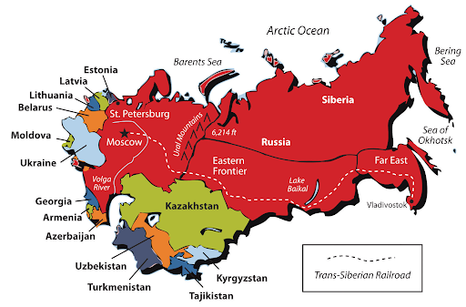
The vastness of Russia cannot be overestimated. Its northern latitude and size contribute to the type D (continental) climate that dominates the realm. Because most of the Russian realm is far from the moderating effects of oceans, temperatures are extreme. Winters are very cold, and summers are very hot. Furthermore, precipitation is highly variable.
Although Russia's physical landscape ranges from Lake Baikal, the deepest lake in the world, to Mount Elbrus, a dormant volcano in the Caucasus Mountains, it has large contiguous areas with little variation in elevation. These extensive plains, steppes, and plateaus are covered in forests, grasses, and wetlands. Because some of Russia extends into the Arctic, tundra covers its northern extent.
Review:
3b. Explain how the Czars expanded their territorial power to create the Russian Empire
- Given its vast land area, how did the czars convince their subjects to minimize their cultural differences?
- What is Russification?
- What were the political cores of the Russian Empire?
As the largest territorial empire in the world, it is not surprising that it included many different ethnic groups, including people who spoke many different languages and practiced different religions, among many other differences. Their identity was tied to that ethnic group, not Russia. The czars engaged in Russification to turn all of their subjects into Russians through language instruction and conversion to Russian Orthodoxy. This attempt to create a Russian identity was less successful the farther the people were from Moscow, the center of power.
The political cores of imperial Russia were St. Petersburg and Moscow. Peter the Great established St. Petersburg in the early 18th century to rival European cities, moving the capital there from Moscow. Although Moscow was no longer the capital, it remained an important city. Throughout the imperial period, Russia expanded from St. Petersburg and Moscow east toward the Pacific Ocean, south to the Black Sea and Caucasus Mountains, and west to Poland and Finland. Lenin moved the capital back to Moscow in 1917 following the Russian Revolution.
Review:
3c. Compare and contrast how issues of ethnic diversity were handled under the Russian Empire and the Soviet Union
- What did the Republics of the USSR represent?
- How did the Soviets hope to dilute ethnic minorities?
Rather than teaching these ethnic groups the Russian language and converting them to Russian Orthodoxy as the czars attempted to do, the Soviet central government organized them into units they could control from Moscow. The Union of Soviet Socialist Republics (USSR) consisted of fifteen Soviet Socialist Republics (SSRs). The largest, the Soviet Federated Socialist Republic (shown in red in the following map), included the area that the central government considered to be ethnically Russian. The remaining SSRs represented separate ethnic groups such as the Georgians, Kazakhs, Ukrainians, and Uzbeks, among others.
These SSRs had very little autonomy. Indeed, the central government sought to dilute these ethnic groups by sending ethnic-Russians into these SSRs. Members of these ethnic groups were also exiled to the hinterlands of the Soviet Federated Socialist Republic to separate them from the historic homeland of their people. Thus, it is common to find ethnic Russians who have lived in Kazakhstan (the former Kazakh SSR) and ethnic Ukrainians who have lived in Siberia (part of the former Soviet Federated Socialist Republic) for generations.
Review:
3d. Describe some of the environmental problems facing Russia today
- What are the types of pollution associated with industrial and urban activity in Russia?
- What environmental problems are the taiga and tundra areas of Russia experiencing?
- How has Russia disposed of nuclear waste?
Russia's large territory means there are more opportunities for environmental damage and a greater chance that the damage will either go unnoticed or be ignored.
- Sewage and chemical pollutants from industrial centers and urban areas have contaminated the air, waterways, and water bodies, including the Black Sea, the Caspian Sea (the world's largest inland body of water by area), and Lake Baikal (the world's oldest and deepest lake). In spite of its designation as a UNESCO World Heritage Site, proposed oil and gas exploration also threatens Lake Baikal's biodiversity.
- Oil exploration and production pollution, including oil spills, have contaminated both the Siberian tundra and taiga environments. Nuclear waste is dumped in the Arctic waters of the Barents Sea. Given their remoteness, concern for these vast ecosystems and the humans who live there have only recently received attention.
- Coal-burning utilities, mining, and smelting activities in and around Siberian cities reduce air quality. The smog in Krasnoyarsk, a Siberian city on the Yenisei River, causes Black Sky emergencies.
- Overfishing depletes fish stocks in the Black Sea and Caspian Sea. These water bodies are the source of the increasingly rare caviar-producing wild sturgeon.
Many of Russia's current environmental problems date to Soviet-era industrial practices.
Review the Regional Environmental Problems described in Introducing the Realm.
3e. Define the main tenets of a socialist economy
- How did the USSR implement socialism?
- What role does the government play in a socialist economy?
Socialism encompasses a wide range of economic and social systems, and not all countries implement it in the same way. Under Stalin, the USSR forced the conversion of large family farms and privately held land and businesses to collective or state control. Collective ownership of the means of production is a fundamental tenet of socialism, but the methods used in the USSR are not. In the Soviet Union, collectivizing agriculture was meant to increase food production; instead, it was a significant factor in the devastating famine of 1932 - 1933. It is estimated that four million people starved to death in the Ukrainian SSR alone.
The central government of the USSR implemented another tenet of socialism when it took control of the economy rather than allowing it to be driven by supply and demand. This command economy allocated inputs, established output quantities, and eliminated competition. To achieve these aims, Stalin executed millions of people who did not agree with him. Central control of the economy to achieve equality is a component of socialism, but the methods Stalin used to implement and maintain that control are not.
Review The USSR and the Russian Federation, an explanation of socialism and the USSR's implementation of it as a socialist state.
3f. Discuss the collapse of the Union of Soviet Socialist Republics (USSR)
- How did the war in Afghanistan contribute to the decline of the USSR?
- What did Mikhail Gorbachev's reforms reveal about the Soviet economy?
- Why did the central government allow the SSRs to break away?
Many factors contributed to the collapse of the Soviet Union. The USSR's efforts since 1979 to maintain communism in Afghanistan was costly and exacerbated the already decaying economic situation that followed World War II. The political structure inside the Soviet Union was also faltering, and its control over the Eastern European countries behind the Iron Curtain was fading. President Mikhail Gorbachev implemented reforms, such as perestroika and glasnost, to modernize the country, but they only served to further reveal the structural problems with the economy, including corruption, waste, and fraud. Hard-line communists sought to wrest power from Gorbachev but were unsuccessful. The SSRs that wanted independence sensed weakness in Moscow and began to break away from the Soviet Union.
Review The USSR and the Russian Federation and the events leading up to the dissolution of the USSR.
3g. Describe the post-Soviet economic and political situation
- What reforms did President Boris Yeltsin implement to transition to a capitalist economy?
- What were the economic effects on the Russian people during this period?
The economic, political, and social situation in Russia following the collapse of the Soviet Union was tumultuous.
- Although there were more freedoms and access to Western goods increased, many people suffered significant financial loss and uncertainty.
- The transition to an open market economy was known as shock therapy, because it would be painful but brief.
- Unfortunately, the pain continued, particularly for ordinary workers. President Yeltsin privatized state-owned enterprises, stabilized the ruble, and lessened government control on pricing, among other reforms.
- Inflation sky-rocketed, people lost what little they had, and unemployment increased as new owners sought to cut costs.
- The business elite were the only segment of the population that benefited during this transition period, rapidly accumulating wealth at the expense of others.
These Russian oligarchs continue to wield considerable power despite U.S. sanctions whereas ordinary citizens find it increasingly difficult to make ends meet.
Review The USSR and the Russian Federation, an overview of the economic, political, and social conditions that characterized Russia between 1991 and 2000.
3h. Explain the Chechen-Russian conflict
- Why were territories such as Georgia and Armenia allowed to separate from the USSR in 1991 but Chechnya was not?
- How has Chechnya's location and physical landscape contributed to its cultural landscape and the identity of its people?
Chechnya was part of the Soviet Federated Socialist Republic rather than a SSR such as Georgia and Armenia. Because Chechnya was administratively part of the Russian SSR, it had no right to secede. Furthermore, Russia feared that if some territories were allowed independence, many others would follow. Thus, Russia has fought to retain control of Chechnya. Chechnya's strategic location and oil-rich potential are also strong motivating factors for Russia to maintain its control.
Due to its position as a crossroads between the Ottoman, Persian, and Russian Empires and its mountainous terrain, Chechnya's history is a turbulent one.
- Chechnya is located in the Caucasus mountains, which is home to numerous ethnolinguistic groups all of which have their own identity.
- These ethnic groups have long been separated by terrain yet routinely invaded by larger territorial powers because of its strategic value.
- For example, Russia's interest in the Caucasus, including Chechnya, goes back hundreds of years.
- The Chechens turned to the Ottoman Empire for protection from Russia's encroachment. To gain the favor of the Ottomans and show their resistance to the Russians, the Chechens converted to Islam.
Like Dagestan and other Russian-controlled territories in the North Caucasus, Chechnya takes pride in its cultural identity and continues to strive for independence.
Review Regions of Russia, the section on Southern Russia.
3i. Discuss the reasons behind Russia's invasion of Georgia in 2008
- Explain why there is unrest in Georgia.
- Why did the residents of the South Ossetia region within Georgia welcome a Russian invasion in 2008?
- Why has Georgia long been a target of invasion?
The country of Georgia, a former SSR, includes several ethnolinguistic regions that are not ethnically Georgian, including South Ossetia, Abkhazia, and Adjara which have sought independence from Georgia.
- South Ossetia is part of a larger region known as Ossetia, which straddles the North Caucasus and the Transcaucasus.
- The South Ossetians have sought independence from Georgia since Georgia broke away from the USSR.
- In 2008, Georgia tightened its control over the region by force, leading to Russia's invasion to support the Ossetian goal of independence
- Although South Ossetians are neither ethnically Georgian nor Russian, they see Russian support as useful for achieving independence from Georgia.
Russia's invasion of Georgia was not the first time a foreign power has sought to seize control of its territory. As part of the Caucasus region, Georgia is located on the strip of land between the Black Sea and Caspian Sea. The area has long been a heavily traveled route, connecting east and west. The Romans, Persians, Arabs, Mongols, Ottomans, Persians, and Russians have all conquered this territory since the 4th century BCE.
Review Transcaucasia in Regions of Russia.
Unit 3 Vocabulary
This vocabulary list includes terms that students need to know to successfully complete the final exam for the course.
- biodiversity
- Black Sea
- business elite
- Caspian Sea
- Caucasus Mountains
- Chechnya
- collective ownership
- command economy
- communism
- contiguous
- czars
- Georgia
- glasnost
- hinterlands
- inflation
- Iron Curtain
- Lake Baikal
- Lenin
- Mikhail Gorbachev
- Moscow
- oligarchs
- open market economy
- Peter the Great
- perestroika
- plains
- plateaus
- ruble
- Russian Orthodoxy
- Russification
- socialism
- Soviet Federated Socialist Republic
- Soviet Socialist Republics (SSRs)
- St. Petersburg
- Stalin
- steppes
- taiga
- tundra
- type D (continental) climate
- Union of Soviet Socialist Republics (USSR)
Unit 4: North America
4a. Describe the physiographic regions of North America
- What are the mountain landforms that separate North America's Atlantic Coastal Plain, Interior Plains, and Intermontane Plateaus?
- Why does the east coast have a Coastal Plain but the west coast does not?
- Explain why the Canadian Shield is sparsely populated.
The Appalachian Highlands separate the Atlantic Coastal Plain and the Interior Plains, including the Great Plains and the Central Lowlands. The Rocky Mountains separate the Interior Plains and the Intermontane Plateaus, including the Basin and Range Province. The Pacific Mountains are the western border of the Intermontane Plateaus and North America. The west coast of North America lacks a coastal plain because it is an active tectonic plate boundary. The west coast is characterized by earthquakes and volcanic activity, whereas the east coast is not. The Atlantic Coastal Plain is in the interior of the North American Plate, about 2,000 miles from its eastern edge. The northern portion of North America is dominated by the Canadian Shield. During the Ice Age, continental glaciation removed the soil from this area and deposited it in southern Canada and the northern United States leaving the bedrock known as the Canadian Shield exposed.
Review:
- The Environment and Human Activity: the Tectonic Plates section
- Introducing the Realm: North America's physiographic regions and physical geography
- Regions of the United States and Canada: the sections on The Pacific Coast and The North
4b. Explain the two dominant climate patterns in North America
- What is the general temperature pattern of North America from north to south?
- Why does the western United States experience a strong rain shadow effect?
In North America, temperatures generally get warmer from north to south. Recall that the Earth is a sphere so places closer to the Equator receive more direct sunlight than places that are farther away. In the United States, precipitation generally decreases from east to west. The Pacific Mountains create a rain shadow effect that limits precipitation in much of the western half of the United States, including eastern Washington and Oregon, the Great Plains, and the Desert Southwest. The east coast lacks a coastal mountain range that would prevent moisture-laden air from reaching the interior.
Review:
- Geography Basics: the Climate and Latitude section
- The Environment and Human Activity: the Climate and Human Habitation section
- Rainshadow, Adiabatic Process, and Relative Humidity
- Introducing the Region
4c. Discuss the three European countries that significantly influenced the development of North America, which regions they dominated, and the long-term impact of their actions
- What was the impact on the indigenous populations of North America when European colonists arrived?
- Where, in North America, did the different colonial powers settle?
- What is the current evidence of colonial influence in North America?
Britain, France, and Spain all altered the physical and cultural landscape of North America. It is estimated that the colonists reduced the indigenous populations of North America by 80 to 90% initially through the spread of disease and eventually violence as the colonists sought to seize land. The colonists arrived from different directions, dominating parts of North America accordingly.
- The British arrived on the eastern seaboard, settling in areas from South Carolina to New England. They eventually turned their sights northward, entering Canada by way of Hudson Bay.
- The French arrived from the north, entering the Gulf of St. Lawrence. They penetrated Canada, the Great Lakes, and made their way down the Mississippi River Valley.
- The Spanish arrived from the South, establishing the oldest colonial city in North America, St. Augustine, Florida. They also made their way into the Desert Southwest, Texas, and California.
The evidence of European colonialism exists today in the languages spoken, the names of places, and patterns of land use. In the case of Canada, it is also part of the British Commonwealth.
Review Introducing the Region.
4d. Examine the population distribution of the United States and Canada using thematic maps of population density
- Where do most people in North America live?
- How has the mobility of North America's population changed over time?
The population of North America is predominantly urban with vast expanses of sparsely populated land. The urban areas are generally coastal or along rivers and lakes. As populations increased on the east coast of North America, it became increasingly necessary to support that growth with agricultural production and natural resources. Thus, the urban areas in the interior of North America, such as Winnipeg and Denver, typically are gateways to these activities. Other interior cities grew up along the transcontinental railways of Canada and the United States including, for example, Saskatoon and Omaha.
The population of the U.S. has been more mobile than that of Canada. It is estimated that U.S. residents move once every seven years whereas Canadians move, on average, only about once every fifteen years. Initially, U.S. mobility was in the form of the rural-to-urban shift. More recently, the shift has been from urban to suburban locations. In both Canada and the United States, there has been a westward movement as people leave the densely populated core regions for job opportunities, a lower cost of living, and a more relaxed lifestyle.
Review Introducing the Realm, the section titled Population Distribution in North America.
4e. Explain the origin of the geographic boundaries of the United States
- How did the United States acquire its territory?
- Why are the boundaries between many states irregular?
The United States acquired territory through treaties, purchase, annexation, and outright seizure.
- The Treaty of Paris in 1783, for example, included British cession of territory up to the Mississippi River to the United States.
- In 1803, the United States negotiated with France for the Louisiana Purchase. In today's currency, the price was about $309 million.
- The United States annexed Texas in 1845 and it became the 28th state. Texas had applied to the U.S. for annexation when it declared its independence from Mexico in 1836. As a slave-holding region, it was originally denied.
- Throughout this time period, Native Americans were often forcibly removed from their land. The Indian Removal Act forced Native Americans tribes from their land in Georgia in exchange for land in Oklahoma so whites could be settled there and grow cotton.
The boundaries resulting from these territorial acquisitions were often irregular because they followed the physical landscape. The Mississippi River, for example, provides the border for numerous states. Because features like these change over time, state boundaries change, too.
Review:
- United States: Early Development and Globalization: the section titled Early Development Patterns
- Map of North America
4f. Identify migration patterns of the United States during the period of westward settlement
- What were the destinations for settlers from the New England culture hearth versus the destinations for settlers from the Mid-Atlantic culture hearth?
- What did it take to get settlers to migrate farther west into the Great Plains and the west coast?
Both groups followed primarily westward paths, although those migrating from the Mid-Atlantic culture hearth deviated from that because of the terrain.
- Some people migrating from the New England culture hearth settled in New York State, including the shores of Lake Ontario and Lake Erie. Others continued to the shores of other Great Lakes and the upper Midwest, including Wisconsin and Minnesota.
- Some of the Mid-Atlantic settlers made their way to the interior of Pennsylvania and settled in the interior lowlands of the Appalachian Mountains. Others followed the Great Appalachian Valley south to Kentucky. Still others left the Great Valley behind, crossing the piedmont region of the Appalachians into western Pennsylvania to the Ohio River Valley.
Evidence of these migration patterns is seen today. Families in western New York on the Erie lakeshore can, for example, trace their ancestry to places like Connecticut and Massachusetts.
Three events contributed to westward migration beyond the Missouri River.
- California's gold boom in 1849, the Homestead Act of 1862, and the completion of the transcontinental railroad in 1869 all facilitated settlement of the western part of the United States.
- Despite these inducements, much of the United States between the Missouri River and the Pacific Mountains remains sparsely populated.
- Cities attract much of the population in these regions.
The climatic conditions and terrain, among other factors, make the interior of the United States a relatively harsh environment for many to live.
Review:
- Introducing the Realm
- United States: Early Development and Globalization: the section titled Westward Expansion and European Immigration
4g. Examine urban growth patterns of the United States and its connection to new forms of transportation
- What allowed cities to increase in size beginning in the late 19th century?
- Why did cities become increasingly decentralized in the 1920s?
- Why have edge cities supplanted central business districts (CBDs)?
The pattern of urban growth often follows a radial pattern with transportation routes radiating from the original center of what was a walking city.
- When the streetcar was invented in 1888, people were no longer limited by walking distance to navigate the cities in which they lived. They could live farther away and count on the streetcar to get them to jobs, goods, and services. Their only limitation was walking distance to streetcar stops.
- The streetcar meant that the city was no longer confined to a small, densely populated area. It could now expand beyond the city center. This trend continued as transportation opportunities increased to the point that edge cities developed.
- People with automobiles who could afford to leave old urban areas began migrating to areas even farther from the city center.
- These suburban developments grew to have their own job and shopping opportunities meaning residents no longer needed the old city's central business district (CBD).
The original city centers of the New England and Mid-Atlantic culture hearths, such as Boston and Philadelphia, are now connected by edge cities, suburbs, highways, and railways to form a densely populated corridor known as the Northeast megalopolis.
Review United States: Early Development and Globalization, the section titled Industrial Development and Urbanization.
4h. Describe the economic patterns that aided the United States in becoming the world's largest economy
- What are the categories of economic activity that are indicative of a post-industrial economy like that of the United States?
- How has the United States extended its influence around the world?
Although the United States engages in all four categories of economic activity, it is the increase in the tertiary and quaternary activities and the decrease in the primary and secondary activities that characterize it as a post-industrial economy. In 2010, about 77% of the GDP in the U.S. was in the service sector (tertiary and quaternary activities), whereas industry (a secondary activity) accounted for about 22% and agriculture (a primary activity) accounted for about 1%. That trend continues with an even higher percentage of tertiary and quaternary activities accounting for the total GDP.
The trend toward services and information and away from primary and secondary activities facilitates the ability of the United States to influence the economic and cultural landscapes of other countries. Brands from U.S. companies are now found all over the world. Media outlets carry advertisements for goods and services from these countries and the language to communicate their availability is in English. Although people from some countries around the world appreciate this increased access, others believe it threatens their identities.
Review United States: Early Development and Globalization, the sections titled Economic Changes and Americanism and Globalization.
4i. Define "cultural melting pot" and the "American Dream" and explain why they are significant
- Why is the concept that anyone, regardless of background, can, through hard work, achieve financial success?
- How is the concept of a cultural melting pot related to globalization?
Although it is possible to achieve financial success through hard work regardless of background in other countries, many people around the world associate it with the United States.
- The concept of the "American Dream" is appealing because the potential for improving one's circumstances depend on factors beyond one's control.
- The United States continues to attract immigrants because it offers the possibility of controlling one's destiny.
- The push factors precipitating the decision to migrate include a lack of control over one's own safety, religious practices, access to education and health care, and job opportunities, among many others.
Unfortunately, achieving the American Dream even in the United States, is not always possible for many of the same reasons it is not in the countries migrants leave.
When immigrants arrive, they seek to blend in to avoid bringing attention to their differences. Some go so far as to abandon their traditions. Others seek to balance their cultural heritage with the practices of their new country.
- The idea of a "cultural melting pot" is often a source of pride for the U.S. even if it does not appreciate the people themselves who are the source of that diversity.
- Many U.S. citizens enjoy the cuisine of other countries and celebrate their holidays, including, for example, St. Patrick's Day parades, Cinco de Mayo events, Kwanzaa celebrations, and Lunar New Year festivities.
There is, however, concern that as more cultures are added to the melting pot the more diluted they will become. Instead of many cultures, there will be one global culture.
Review:
- United States: Early Development and Globalization: the section titled Americanism and Globalization
- United States: Population and Religion
4j. Describe the current demographic profile of the United States
- What factors explain the change in the racial and ethnic profile of the United States over the last several decades?
- Where do most Hispanic immigrants to the United States come from?
- What are remittances?
The United States continues to be more racially and ethnically diverse due primarily to immigration. It is also important to note that these groups are aging at different rates depending on fertility, mortality, and immigration within these groups.
- According to 2019 Census Bureau estimates (accessed on 5 May 2021), the highest percentage of the population is White and non-Hispanic at about 60%, but it is declining due to low birth rates and increases in other populations.
- The Hispanic or Latino population continues to grow due to immigration and higher birth rates. Currently, this group accounts for over 18% of the U.S. population. The push factors of countries such as Mexico, Guatemala, Honduras, and El Salvador contributing to immigration are considerable.
- The Black and African-American population that is not Hispanic continues to make up about 13% of the U.S. population.
- Asians are 5.6% of the population. In 2010, Asians were the fastest growing ethnic group in California.
- The indigenous populations, including American Indians, Native Alaskans, Native Hawaiians, and other Pacific Islanders, make up about 1.5% of the population.
Many immigrants support their families in their countries of origin by sending them remittances. These are portions of the immigrants' paychecks that, in many cases, provide necessities like food and shelter.
Review United States: Population and Religion.
4k. Explain the regional distribution of religious affiliations in the United States
- What is the dominant religion in the southeastern part of the United States?
- What explains the dominance of the Catholic religion in 40% of U.S. counties?
The pattern of religious affiliations in the United States originally followed the pattern of settlement, Puritans in the New England culture hearth and Anglicans in the Mid-Atlantic culture hearth. Subsequent immigration has changed that pattern.
- The Baptist religion dominates the southeastern United States. Known as the Bible Belt, the Baptist religion practiced in this region is an outgrowth of the Anglican religion brought by settlers to the Mid-Atlantic colonies in the 17th century.
- Immigrants from Italy, Ireland, Poland, and Latin American countries such as Mexico have strongly influenced the dominance of the Catholic religion in many parts of the United States. The distribution of Catholics is similar to the pattern of settlement of immigrants from these Catholic countries.
Although there are distinct patterns in the distribution of major religious affiliations in the United States, there has always been an underlying diversity. There are, for example, numerous branches of these religions.
Review United States: Population and Religion.
4l. Identify the most densely populated regions of Canada
- Where is Canada's ecumene?
- What are the physical and economic factors that contribute to the pattern of settlement in Canada?
Geographers use the term ecumene to mean inhabited zone, the land where humans have settled. In Canada, that zone is primarily near the border with the United States. The climate, terrain, and proximity to its chief trading partner define Canada's ecumene.
Canada's geology and northern location limit the locations where agriculture is possible and human habitation desirable. Thus, most agricultural activity and human settlements are found in the southern parts of Alberta, Saskatchewan, and Manitoba, to the west of the Canadian Shield, and Ontario and Quebec, to the east of the Canadian Shield. Access to the United States for trade purposes also draws settlement to the southern part of Canada. Toronto, Canada's largest city, and Ottawa, its capital, are both located near the border with the United States.
Review:
4m. Explain why there are English-speaking and French-speaking regions in Canada
- Where in Canada do most French speakers currently live?
- How did the British come to control New France?
French and British colonialism explains the English-speaking and French-speaking regions in Canada.
- The French arrived in the 1500s, establishing permanent settlements along the St. Lawrence River in what is now the province of Quebec.
- French influence in this region grew to the point that it was known as New France. The British eventually took control of New France following the Treaty of Paris, organizing it into a British colony called Quebec.
- Given the substantial number of French settlers in the region, the British agreed, under the Quebec Act, to maintain French law, the French language, the Catholic religion, and the French agricultural system to keep the peace.
Although the French influence remains strong in Quebec, the British colonial influence is stronger throughout Canada.
Review:
- Introducing the Realm
- Physical Geography of Canada
- Regions of the United States and Canada: the section on French Canada
4n. Identify cultural differences between French-speaking and English-speaking populations in Canada
- Why does the province of Quebec want to separate from Canada and become an independent country?
- What has the non-Francophone portion of Quebec threatened should Quebec leave Canada?
The majority of Quebec's citizens consider themselves more French than Canadian.
- Almost 80% of Quebecers are Francophones.
- Quebers also justify their need for sovereignty through their history as a people conquered by the British.
- They fear their culture will be lost through assimilation with the English-speaking culture of the rest of Canada.
- They resent that they must learn English but the rest of Canada is not required to learn French. They also perceive an anti-Quebec bias in the media.
- Although religion is not as important as it once was, Quebec culture is still tied to the Catholic church.
Although they are in the minority, the Cree of northern Quebec have considerable influence because that is where the hydroelectric dams and the natural resources the Francophones depend on are located. They, along with other non-Francophones, would not join the rest of Quebec should it secede.
Review on Physical Geography of Canada.
4o.Discuss patterns of population growth and decline in various regions of the United States and Canada
- Where have the economic cores of the United States and Canada traditionally been?
- What regions have experienced the most growth since 2000?
The European settlement of North America partly explains the growth of the east coasts of Canada and the United States. The Northeast Megalopolis of the United States and the Quebec City - Windsor, Ontario Corridor represent the economic cores of both countries. In both cases, suburban growth and the development of edge cities away from those cores has been substantial. In the case of the United States, however, the population of that area has been declining in its Northeast Core, particularly in the Rust Belt cities.
The Mountain West and American Southwest have experienced the most growth in the United States since 2000. Las Vegas, Denver, and Salt Lake City are popular destinations for people leaving the Northeast Core. In Canada, British Columbia's Vancouver continues to grow although much of that growth is on the periphery. As the most densely populated city in Canada, it is very expensive to live there. The same phenomenon is occurring around Toronto, Canada's largest city and a key link in the Quebec City - Windsor, Ontario Corridor. Elsewhere in Canada, growth is occurring in Halifax, Nova Scotia, and the Prairie cities of Saskatoon, Calgary, and Edmonton.
Review:
4p. Examine the environmental consequences of rapid population growth in the Mountain West region of the United States
- Why is there a looming water crisis in Las Vegas?
- Why are people moving to the Mountain West region of the United States?
The Mountain West includes arid states that have attracted extraordinary population growth. Cities in this region, including Las Vegas and Phoenix, rely on the Colorado River for their water. To provide ready access to water for the growth of these cities and farmland irrigation, the U.S. government built the Hoover Dam, creating a reservoir, Lake Mead, on the Colorado River.
People seeking job opportunities in the growing tertiary sector, a lower cost of living, and a more favorable climate have caused the increase in the growth of Mountain West cities like Las Vegas. Water resources have not, however, increased. Drought conditions have exacerbated the drop in Lake Mead water levels, requiring Las Vegas residents to reduce their per capita water usage.
Review the Mountain West section in Regions of the United States and Canada.
Unit 4 Vocabulary
This vocabulary list includes terms that students need to know to successfully complete the final exam for the course.
- active tectonic plate boundary
- agriculture
- Alberta
- American Dream
- Appalachian Highlands
- arid
- Atlantic Coastal Plain
- Baptist
- Basin and Range Province
- Bible Belt
- Britain
- British Commonwealth
- Canadian Shield
- Catholic
- Central Lowlands
- coastal plain
- colonists
- Colorado River
- cultural melting pot
- drought
- earthquakes
- ecumene
- edge city
- France
- Francophones
- Great Plains
- Hoover Dam
- Indian Removal Act
- indigenous populations
- industry
- Interior Plains
- Intermontane Plateaus
- Lake Mead
- Louisiana Purchase
- Manitoba
- Mid-Atlantic settlers
- New England culture hearth
- North American Plate
- Northeast megalopolis
- Ontario
- Ottawa
- Pacific Mountains
- post-industrial economy
- Quebec
- Quebec Act
- Quebec City - Windsor, Ontario Corridor
- rain shadow effect
- remittances
- Rocky Mountains
- rural-to-urban shift
- Rust Belt
- Saskatchewan
- service sector
- Spain
- Toronto
- Treaty of Paris
- urban
- volcanic activity
- westward migration
Unit 5: Middle America
5a. Describe the differences between the rimland and the mainland of Middle America
- What are the characteristics that explain the division of Middle America into the rimland and mainland regions?
- How did the pattern of land use differ in these regions?
- How does the ethnicity of these two regions reflect their colonial history?
The division of Middle America into two regions based on location and physical geography is evident in the differing occupational activities and colonial dynamics of the rimland and the mainland. In terms of location, the names of the regions indicate their positions as shown in the map below. The differences in the physical geography of the two regions contributed significantly to the resulting patterns of land use.
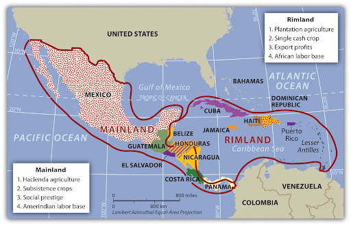
Colonists quickly took over the rimland islands and coastal areas, converting them to plantation agriculture. The origins of plantation agriculture are primarily northern European with the goal being efficiency. A single crop is grown for export on a large plot of land. The native AmerIndian population that survived the diseases the colonists brought provided labor during the harvest. Slaves were brought from Africa to provide the remaining labor, thus altering the ethnicity of many parts of the rimland. The rimland became a mix of primarily people of European and African descent.
It took longer for colonists to penetrate the larger mainland region. Because Spain colonized much of this region, they imposed the hacienda style of land use. This system provided the colonists with social prestige through land ownership rather than profits through exports. There was more crop diversity. The native AmerIndian population engaged in subsistence farming to survive. Slaves from Africa were uncommon, thus the ethnicity of the mainland became a mix of people of AmerIndian and European descent.
Review the section on Rimland and Mainland in the Introducing the Realm.
5b. Summarize the impact of European colonialism in Middle America
- What were the immediate effects of European colonists on the AmerIndians?
- What evidence is there of European colonialism in Middle America today?
European colonists had a devastating effect on the AmerIndians of Middle America. Within a hundred years, between 84 and 90 percent of the population had died due to disease, warfare, enslavement, and execution. The colonists were eager for immediate profit, looting precious metals and gems and seizing land. Many of the changes the colonists brought with them are evident today:
- the Spanish, French, Dutch, and English languages,
- the Christian religions, particularly Catholicism,
- domesticated animals,
- crops,
- building methods, and
- city planning.
Review:
- Introducing the Realm
- Central America: the section on European Colonialism
- The Caribbean: the section on European Colonialism in the Caribbean
5c. Distinguish between the Mayan and Aztec Empires
- Why is Mesoamerica considered one of the ancient cultural hearths of world civilization?
- What is the geographic extent of the Mesoamerican cultural hearth?
Mesoamerica is one of the places where civilization began. (The term Mesoamerica, meaning "middle America", is Greek but is reserved for identifying this region as it existed prior to the arrival of Europeans.) Because it was influential in creating customs, innovations, and ideologies, it is considered one of the world's ancient cultural hearths.
- The Olmec, Maya, Toltec, and Aztec civilizations, among others, all contributed to the development of this cultural hearth, which extended from central Mexico, including the Yucatán Peninsula, through the isthmus of Central America.
- The Maya predated the Aztecs. They made significant advancements in mathematics and astronomy, developing an accurate calendar. They also made remarkable contributions in architecture, engineering, and the development of the city-state. The Mayan Empire was centered on the Yucatán Peninsula extending west into the present-day Mexican provinces of Chiapas and Tabasco and east into present-day Belize, Guatemala, El Salvador, and Honduras.
- The Aztec Empire extended from southern Mexico into central Mexico, including present-day Mexico City. Mexico City is on the site of the Aztec city of Tenochtitlán, which was the largest and most sophisticated city in the Americas at the time. They conquered other groups, enforcing taxes and demanding respect through involuntary tributes. The Aztecs also made significant advances in agriculture and urban development.
The Aztec were in power when the Europeans arrived. Although the Europeans decimated the Aztecs and other AmerIndian groups, the evidence of the Mesoamerican civilizations remains in their descendents and their art and architecture.
Review Introducing the Realm.
5d. Describe Spanish influence in urban development across Middle America
- What activities dominated the center of Spanish cities?
- Where did the working poor live in the Spanish colonial city?
In Tenochtitlán, temples, palaces, and public buildings dominated the city center and economic activities occurred on the periphery. The Spanish model places the plaza or marketplace in the center.
- The plaza's boundaries are the church, government buildings, residences for the wealthy, and permanent stores.
- This perimeter and the plaza it surrounds constitute the city's core.
- As the distance from the core increases, the income of each residential zone decreases.
- Thus, Spanish cities grow by adding more concentric rings. As more rings are added, there are fewer city services available. The poorest city residents live in the outermost ring, known as barrios, where there are no city services.
The commoners in Aztec society also lived on the urban periphery due to the fact that many were engaged in agricultural activity.
Review Introducing the Realm.
5e. Describe the physical geography of Mexico, identifying the core and peripheral areas
- Why does Mexico have so many different climates?
- What physical features contribute to Mexico's ranking as the fourth most biodiverse country in the world?
- What features characterize Mexico's core and southern peripheral region but not its northern peripheral region?
As the eighth largest country in the world, it is not surprising that Mexico's physical geography would vary.
- The Tropic of Cancer (23.5° N) divides Mexico into two large climatic zones, and its topography divides those into even smaller zones.
- The fact that Mexico's land mass is larger to the north contributes to the effect of continentality away from the coastal areas.
- Mexico's varied topography means that temperatures will be cooler in the mountains and warmer in the valleys and along the coastal plains.
- Mexico's location makes it vulnerable to hurricanes along both its Pacific and Gulf of Mexico coasts.
- Like the United States, Mexico's west coast is the active edge of the North American Plate, resulting in earthquake and volcanic activity.
- Mexico's volcanoes are found in its core and southern peripheral region rather than its northern peripheral region.
Mexico's varied physical geography makes it home to ten to twelve percent of the world's species.
Review:
- Introducing the Realm: the Physical Geography section
- Mexico
5f. Outline the socioeconomic classes in Mexico and explain the ethnic differences of each
- Why is Mexico's social structure shaped like a triangle?
- What is ethnic breakdown of Mexico's population by percentage?
The following figure illustrates all of Middle America's social structure, including the ethnic groups that comprise each socioeconomic class. Mexico's social structure is also a triangle. Europeans make up nine percent of the total population yet control most of the wealth. Although mestizos make up sixty percent of the total population, not all of them have made it to the middle-class. Many of them join the AmerIndians, who make up about thirty percent of Mexico's population, in the labor base at the bottom.

Review the section on Mexican Social Order in Mexico.
5g. Explain how the North American Free Trade Agreement (NAFTA) and maquiladoras have influenced economic and employment situations in Mexico
- What was the purpose of NAFTA?
- What are maquiladoras?
The North American Free Trade Agreement (NAFTA) was a treaty between Canada, Mexico, and the United States that was in place from 1994 to 2020. The purpose of NAFTA was to reduce barriers to trade and investment between the three countries and has been beneficial to their respective economies. There have, however, been concerns that the economic growth has favored only some segments of society and that the environment and employment have suffered in some regions.
NAFTA led the United States to build manufacturing plants known as maquiladoras across the border in Mexico to take advantage of cheaper labor. Although maquiladoras provide jobs for Mexicans and cheaper goods to U.S. residents, there are disadvantages to both the workers and the environment. Maquiladoras exploit workers because Mexico's labor laws do not protect them from working longer hours with few benefits. Furthermore, housing and infrastructure are inadequate, causing extensive slum areas to grow around the maquiladoras.
Review the section on NAFTA and Maquiladoras in Mexico.
5h. Describe how the physical environment has affected human activity in Central America
- What is the dominant physical landscape in Central America?
- Explain altitudinal zonation.
Mountain ranges, lowlands, and coastal plains characterize the physical landscape of Central America, with mountainous terrain being the most prevalent. Because of the ubiquity of mountain ecosystems, the residents of Central America have adapted their activities based on altitudinal zonation as shown in the following figure. Thus, different crops are grown at different elevations.

Review:
- Introducing the Realm: the Physical Geography section
- Central America
5i. Discuss how the United States has affected Middle America
- What interests does the United States have in countries such as Guatemala and El Salvador?
- What is the geographic significance of Panama?
- Why did the United States become involved in Nicaragua?
- What Central American countries signed CAFTA?
The United States' economic and political interests have long affected countries in Middle America.
- The United States overthrew Guatemala's government because its social reforms conflicted with the highly profitable U.S. business United Fruit Company (UFC), now Chiquita Brands International.
- The U.S. also interfered in El Salvador's government to protect its coffee interests. The U.S. supported the wealthy landowners over the peasants who worked that land.
- The United States became involved in Nicaragua in the 1980s when the Sandinista National Liberation Front, a socialist political party, took power. The U.S. supported the Contras in their efforts to bring down the Sandinista government.
- The United States sought to shorten the shipping distance between New York and California so it took over the Panama Canal project from the French in the early twentieth century. The construction of the canal had an environmental impact and changed the cultural landscape of the area. Turning over control of the Panama Canal to Panama proved to be a political rather than an operational issue.
Although U.S. involvement in Central America has been destructive, it has contributed to the economies of some Central American countries.
- Costa Rica is a popular tourist destination for U.S. residents.
- The U.S. has joined Costa Rica, El Salvador, Guatemala, and Honduras in the Central America Free Trade Agreement (CAFTA), which seeks to create new and improve existing economic opportunities by reducing tariffs and opening markets, among other benefits.
- The Dominican Republic joined CAFTA in 2004, so it is now known as CAFTA-DR.
Review the section on The Republics: Diverse Political Geography in Central America.
5j. Compare and contrast the Central American republics
- Which Central American country's lingua franca is English?
- Why does Costa Rica have the nickname the Switzerland of Central America?
- Why do Belize and Panama have higher percentages of people of African descent?
- What have been the barriers to progress for many Central American countries?
Although these countries are similar in terms of their physical landscapes and colonial history, their cultural, political, and economic landscapes vary.
- As the only Central American country colonized by the British, Belize's lingua franca is English. Spain colonized the other Central American countries.
- Like Switzerland in Europe, Costa Rica is considered politically and economically stable compared to the other countries in the region. Multinational companies move here to take advantage of the stability, relatively low labor costs, and supportive environment for their employees.
- The British brought slaves from west Africa to work in what is now Belize. The U.S. imported laborers of African descent from the Caribbean to work on the Panama Canal.
- Guatemala, El Salvador, Honduras, and Nicaragua have all found political, economic, and social stability hard to come by due to corruption and gang violence, among other challenges.
In addition to these examples, there are many more similarities and differences between the seven republics of Central America.
Review Central America.
5k. Explain the reasons for constructing the Panama Canal
- Prior to completion of the Panama Canal, what route did ships have to take to travel between the Pacific and Atlantic Oceans?
- What was the impact of the Panama Canal on trade between the United States and the rest of the world?
Before construction of the Panama Canal, ships had to travel 12,000 miles to reach New York from San Francisco. Rather than traveling around the southern tip of South America, the Panama Canal made it possible to shorten the trip to 4,000 miles. In addition to easing the transportation of commercial cargo from one coast to the other, the Panama Canal also facilitated international relations with countries in the Pacific. The Panama Canal opened a new corridor between the East and West.
Review the section on Panama and the Panama Canal in Central America.
5l. Describe the effect of colonialism in the Caribbean
- In addition to Spain, what other European countries colonized the Caribbean?
- What is the current ethnic makeup of the Caribbean countries?
The effect of colonialism on the Caribbean countries differs somewhat from the other countries in Middle America. In addition to Spain, Great Britain, the Netherlands, France, and the United States colonized the islands of the Caribbean. Sweden, Belgium, Denmark, and Portugal also had a colonial influence. On some islands, there is still an active colonial presence as is the case in the U.S. territory of Puerto Rico, for example. The language of the colonists is still spoken in many Caribbean countries. Haiti, as a former French colony, has two official languages, French and Haitian Creole.
The ethnic makeup of the Caribbean countries also varies more than Mexico and most of the countries of Central America. Although the effect on the indigenous populations was the same, decimation through disease and subjugation, the African and Asian influence is greater. The colonists of these countries were more likely to import slaves from west Africa to labor in the plantations. When slavery was outlawed, colonists brought indentured laborers from their colonies in Asia. The British, for example, brought laborers from India to work in Trinidad. Rather than returning to their home countries, these indentured laborers stayed, contributing to the multiethnic heritage of the Caribbean.
Review the section on European Colonialism in the Caribbean in The Caribbean.
5m. List some genres of music that emerged from the Caribbean
- What influences are evident in the genres of Caribbean music?
- What explains the variety of genres coming from the rimland of Middle America?
The rimland of Middle America consists primarily of islands thus facilitating the development of different genres of music. Because the native populations of the islands were decimated due to disease brought by colonists and harsh treatment, little if any remnants of native musical traditions remain. Thus, each island's music evolved according to the origins of the people that settled there either by choice or enslavement. Cuba's music, for example, is a product of the cultures of its African slaves, Spanish colonists, and even Chinese immigrants brought to work in the sugar fields during the 19th century.
Review the section on Caribbean Music in The Caribbean.
5n. Explain how, why, and where hurricanes form
- What conditions result in hurricanes?
- Why is Middle America vulnerable to hurricanes?
Hurricanes begin formation over ocean waters that exceed 80°F and 160 feet in depth.
- The water warms the air above it, causing it to rise and creating an area of low pressure.
- Cooler air is drawn into the area of low pressure, replacing the rising air.
- The rising moisture-laden air begins to cool with altitude, forming clouds.
- This cycle continues as cloud cover increases and thunderstorms develop.
- Because the Earth rotates, so do these storm systems.
- When rotating wind speeds reach 39 mph, the storm is designated a tropical storm. When they reach 74 mph, it is designated a hurricane.
Hurricanes that form north of the Equator, like those affecting Middle America, rotate counterclockwise. Middle America is in the hurricane belt with the rimland and east coast of the mainland vulnerable to hurricanes that develop over the Atlantic and the west coast of the mainland vulnerable to hurricanes that develop over the Pacific.
Review:
5o. Describe the potential danger of hurricanes
- Why do hurricanes cause storm surge?
- What happens when hurricanes make landfall?
- How do hurricanes affect tourism in the Caribbean?
The force of hurricane winds moving cyclonically around a storm causes water to be pushed up in the center, creating a storm surge. As the storm moves toward shore, it encounters the continental shelf causing that storm surge to be pushed even higher. Storm surge is often the greatest threat from hurricanes due to the devastating impact on life and property. When the hurricane makes landfall, the storm begins to weaken but not without causing extensive damage from high winds, heavy rainfall, and extensive flooding. Although Caribbean cruises still operate during hurricane season, they do have contingency plans in place and encourage travelers to be flexible when scheduling their trips.
Review:
Unit 5 Vocabulary
This vocabulary list includes terms that students need to know to successfully complete the final exam for the course.
- African
- altitudinal zonation
- AmerIndian
- Aztec
- barrios
- Belize
- Caribbean
- Central American Free Trade Agreement (CAFTA)
- CAFTA-DR
- Chiquita Brands International
- city-state
- Coasta Rica
- concentric rings
- Contras
- cultural hearths
- Dominican Republic
- El Salvadore
- European
- Guatamala
- hacienda
- Haiti
- Honduras
- hurricanes
- hurricane belt
- indentured laborers
- isthmus
- lingua franca
- Maya
- mainland
- maquiladoras
- Mesoamerica
- mestizos
- Middle America
- mountain ecosystems
- multiethnic
- Nicaragua
- North American Free Trade Agreement (NAFTA)
- Olmec
- Panama Canal
- periphery
- plantation agriculture
- plaza
- Puerto Rico
- republics
- rimland
- Sandinista National Liberation Front
- socioeconomic class
- species
- storm surge
- subjugation
- Tenochtitlán
- Toltec
- topography
- trade winds
- Tropic of Cancer
- United Fruit Company (UFC)
- urban development
- Yucatán Peninsula
Unit 6: South America
6a. Summarize the main physical features and characteristics of South America
- What landforms and land cover types characterize South America's physical landscape?
- How do South America's location and landforms affect its climate?
- Where are the agricultural regions of South America?
Given the size of South America, it is no surprise that it has a varied physical landscape, including mountain ranges, valleys, rivers, lakes, deserts, plains, plateaus, and highlands.
- As the longest mountain chain on Earth, the Andes Mountains form the west coast of the continent. This area is tectonically active.
- The valleys, or altiplanos, between the Andes mountain ranges provide fertile agricultural land.
- South America's plateaus, plains, and highlands are also agricultural regions, including, for example, the Pampas and the Mato Grosso Plateau.
- Some highlands, such as the Guiana Highlands are too rugged and remote for agricultural activity.
- Although many people associate the Amazon River Basin with Brazil, it covers more than a third of the continent, including Peru and Ecuador to the west, Bolivia to the south, and Colombia, Venezuela, and other northern countries.
- Tropical forests are an iconic image of South America but the realm is also home to the driest non-polar desert in the world. The rain shadow effect of the Andes Mountains is responsible for the Atacama Desert of Chile and Peru.
The image of South America's climate is often associated with the tropical Amazon Rainforest. Not all of the continent, however, straddles the Equator. Because the South American continent extends from 12° N to 54°S, its climate varies, including tropical, temperate, arid, cold, and polar climate types. Furthermore, there are variations within those climate types due to local topography.
Review Introducing the Realm.
6b. Analyze colonial domination within South America and how the continent was divided
- Why did Spain colonize the west side of South American and Portugal the east side?
- What is the significance of the Tordesillas Line?
- How did the colonial experience of the Guianas differ from the rest of South America?
The countries of Europe's Iberian Peninsula, Spain and Portugal, colonized all of South America with the exception of the Guianas, present-day Guyana, Suriname, and French Guiana. As shown in the following figure, Spain's invasion of South America focused on the west coast because they were already in Middle America, which borders present-day Colombia. Francisco Pizzaro, a Spanish conquistador stationed in Panama, is credited with beginning the Spanish colonization of South America, landing in Peru to search for gold and silver. Portuguese colonists sailed directly to South America from Portugal, landing on the east coast in Brazil to seize land for the expansion of their empire.
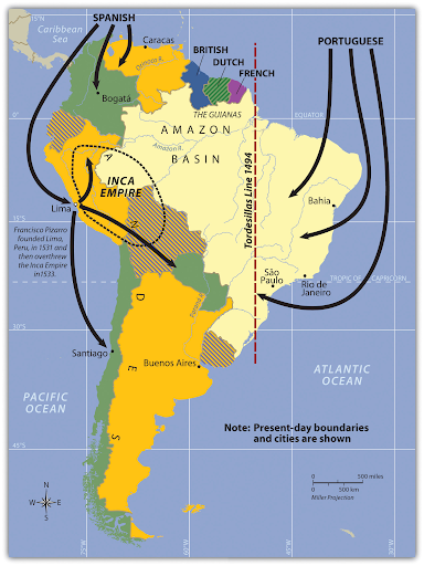
As the Spanish and Portuguese penetrated South America's interior from opposite directions, they eventually claimed the same territory. They turned to the Catholic church to resolve the dispute, establishing a boundary between the two, the Tordesillas Line of 1494. The British, Dutch, and French colonized the Guianas in much the same way they colonized the rimland of Middle America. French Guiana is the only remaining colony on the continent of South America.
Review:
- Introducing the Realm: the section on European Colonialism
- Urban North and Andean West: the sections on Colombia: Drugs, Coffee, and Oil and Rural Amerindian States of Ecuador, Peru, and Bolivia
- Brazil - The Amazon Basin: the section on A Portuguese Colony
- The Southern Cone: the section titled Population and Culture
6c. Identify the main cultural regions of South America
- What are the physical and human characteristics of South America that define the five main cultural regions?
- Why is the realm of South America more integrated now than when these cultural regions were delineated?
In some cases, the following map reflects both South America's physical and human geography.
- The Tropical Plantation Region represents the coastal edge the Portuguese colonized.
- The Rural Amerindian Region follows part of the Andes Mountain range. This is also an area that attracted Spanish conquistadors with its mineral resources.
- Although the Amazon Basin is much larger than the region shown on the map, it does represent the core of the Basin. Colonists did claim this territory even though it was, until the early 1970s, largely impenetrable.
- The Mixed Mestizo Region is less easily identified based on physical geography. Instead, it is a transition zone between wealthy and poor regions.
- The European Commercial Region, or Southern Core, includes the fertile soils of the South American realm. The agricultural activity here has contributed to the economic growth and European investment in the area.
Technology and globalization have integrated these regions to a certain extent but they still provide a useful framework from which to understand an entire realm.

Review the section titled Cultural Regions of South America in Introducing the Realm.
6d. Summarize the production of the three main export products of Colombia
- Where, in Colombia, are these products grown?
- What aspects of Colombia's physical geography contribute to the cultivation of these crops in Colombia?
Three of Colombia's main exports include cocaine, oil, and coffee.
- The coca plant that is used to make the drug cocaine grows on the low-altitude slopes of the Andes where the climate is tropical. These areas are typically remote, making it easier to cultivate without detection. In 2020, Colombia was still the world's largest cocaine producer.
- Colombia exports more oil, also known as petroleum, than any other product. Its petroleum resources are in sedimentary basins where there were once geologically ancient seas in the northwest and center of the country.
- After petroleum products and coal products, coffee is Colombia's biggest export. Colombia's physical geography is ideal with a tropical climate and mountains. Specialty coffees, in particular, grow best at elevations of 3,000 to 6,000 feet.
Gems and precious metals, particularly gold, are an increasingly important export. In 2020, they surpassed coffee in the percentage share of Colombia's exports.
Review the sections on Colombia in Urban North and Andean West.
6e. Compare the three main countries in the Andean West region of South America, describe how they gained their wealth, and identify who has benefited the most from that wealth
- What are the main exports of this region?
- What aspects of this region's physical landscape contribute to the economies of Ecuador, Peru, and Bolivia?
The Central Andes and the Amazon River Basin both contribute to the economies of the Andean West countries.
- The sedimentary basins that coincide with Ecuador, Peru, and Bolivia are adjacent to the Andes, on the periphery of the Amazon River Basin. Over 400 million years ago, these basins were seas that later filled with sediments, burying the ancient marine life that would eventually become petroleum and other fossil fuels. Petroleum is Ecuador's leading export and Peru's second-highest export. Natural gas and petroleum are Bolivia's leading exports.
- Mining precious and base metals, including gold, silver, copper, and zinc, among others make up significant portions of these countries' economies. Gold and copper are Peru's leading exports. Gold, zinc, and other precious and base metals are Bolivia's second-highest export. These mines, some of which date to the Spanish conquest, are found in the Andes Mountains.
Clearly, the Andean West has numerous natural resources but the people who live and work in these areas rarely benefit. Furthermore, they often suffer from dangerous working conditions and the environmental damage caused by these extractive industries. The land owners, wealthy elite, and international corporations profit from the abundant natural resources.
Review Urban North and Andean West.
6f. Discuss how Paraguay's geography allowed it to gain wealth and provided opportunities for its people
- What does Paraguay have in common with Bolivia?
- What limits Paraguay's economic growth?
Like Bolivia, Paraguay is a landlocked country. Unlike Bolivia, Paraguay is not in the Andes and has little in the way of natural resources. Paraguay's physical geography consists of dry, grassy plains, wooded hills, and marshlands; only about 10% of its land is arable. Paraguay must, however, rely on agriculture given its few natural resources. Its main exports are soybeans, beef, and electricity from its hydropower dams. In addition to Paraguay's limited natural resources, its economic growth potential is hindered by inadequate infrastructure, political instability, and corruption, all of which contribute to the crippling poverty of most Paraguayans, known colloquially as Guaranis.
Review the section on Paraguay in Urban North and Andean West.
6g. Summarize the ethnic composition of Brazil and discuss why the population is so diverse
- How does Brazil's colonial history differ from the rest of South America?
- What was the Atlantic Trade Triangle?
Unlike most of the other countries in the South American realm, Brazil was a Portuguese colony rather than a Spanish colony. Thus, Portuguese is the lingua franca of Brazil rather than Spanish. The population of Brazil is predominantly White, Multiracial, and Black. European immigration and African slaves explain much of the ethnic diversity of Brazil.
- The Portuguese were part of the Atlantic Trade Triangle, also known as triangular trade, which moved people and goods between Europe, Africa, and the Americas. The trade was not, however, equitable.
- Europe shipped goods to Africa to trade for slaves. The slaves were transported to the Americas to provide labor for the European colonists. The goods the slaves produced were shipped to Europe.
Portugal was the most active country in the slave trade. It is estimated they trafficked more than three million people from Africa to Brazil, more than any other country.
Review the section titled Northern Periphery: The Amazon Basin in Brazil - The Amazon Basin.
6h. Describe the main activities that are involved in the development and exploitation of the Amazon Basin
- What contributed to the growth of the port city of Manaus?
- What is the purpose of the Grande Carajás Project?
- Why is deforestation occurring in the Amazon rainforest?
Although many people are familiar with the exploitation of the Amazon Basin through deforestation, many are not aware of the varied reasons for the removal of large swaths of the Amazon rainforest. Loggers harvest trees for wood products, ranchers clear the land to raise cattle, and miners remove trees to extract precious and base metals, including gold and copper, and iron ore. The Grande Carajás Project facilitates the exploitation of the region by providing the infrastructure needed to support increased mining activity.
Humans have long recognized the value of the Amazon Basin's natural resources. The river port city of Manaus, for example, attracted increasing European attention during the late 19th century because it was a gateway to rubber. Manaus' location on the Rio Negro, a large tributary to the Amazon River, made it possible to easily access the interior of the Amazon rainforest and then ship the extracted rubber to the outside world.
Review the section titled A Portuguese Colony in Brazil - The Amazon Basin.
6i. List the physical characteristics of the various regions of Brazil
- How has the physical landscape of the south region contributed to its affluence?
- Why does the west central region have great agricultural potential?
There is agricultural activity in all of Brazil's regions but the southeast region has been particularly successful due to its good soils, coastal location, and temperate climate. Farmers grow wine grapes, rice, and tobacco. In addition to its success in agriculture, this region also produces all of Brazil's coal.
The west central region includes a tropical savanna ecoregion known as the cerrado. Until recently, it was considered unsuitable for agriculture because the soil quality is poor. The increase in population in the fertile southeast region, shown in the following figure, has, however, forced Brazil to adapt conditions in the west to accommodate agricultural activity. Thus, the soil is being enhanced by adding phosphorus and lime to grow soybeans, grains, and cotton. It is anticipated that the agricultural potential of the west central region will expand even more in the future.
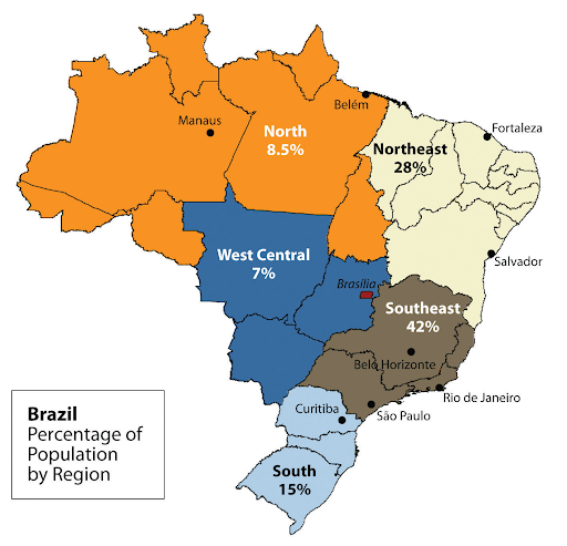
Review Brazil - The Amazon Basin.
6j. Explain the pattern of immigration that created the regional heritage of the Southern Cone
- In terms of ethnic diversity, how does Argentina differ from other countries in South America?
- What was it about the physical geography of the Chaco region that attracted Mennonite immigrants from other countries?
Argentina's population includes people who can trace their ancestry to far more European countries than the rest of South America. Some of these people are descendants of European colonists, but many more are there due to immigration in the 19th and 20th centuries.
- When Argentina declared independence in 1816, it was sparsely populated.
- To remedy that, the government began a campaign in the mid-19th century to bring European immigrants to the country.
- Argentina was second only to the United States in the number of immigrants arriving between 1857 and 1950.
- Immigrants arrived from Italy, Scandinavia, Greece, Ireland, France, Germany, Bulgaria, and many other European countries and Russia.
- More recently, Argentina is a destination for immigrants from southwest Asia.
The Chaco region's rainfall and soils make it an ideal place for farming. Thus, it was an attractive destination for Mennonites, members of the Anabaptist Christian denomination who often live off the land. The Mennonites arriving from Canada sought to do missionary work among the Amerindians in addition to farming, whereas the Mennonites arriving from Russia were fleeing oppression and the loss of their farms at the hands of the Soviets. Today, there are Mennonite communities from all over the world now living in South America.
Review The Southern Core.
6k. Discuss how Chile has emerged as a strong and stable country
- What are Chile's natural resources?
- What has Chile done to counter the economic instability associated with natural resource price fluctuations?
All three of Chile's regions provide natural resources that contribute to its strength and stability.
- Northern Chile's Atacama Desert is a source of minerals, including copper.
- Chile's Central Valley, with its Mediterranean climate, produces a variety of agricultural products, including wine, fruits and vegetables, grains, and beef.
- Southern Chile's forests provide timber resources.
- Chile's extensive coastline provides access to another natural resource, fish. Fishing is a major industry in Chile.
Chile relies on natural resources such as copper that experience price fluctuations. This fluctuation causes uncertainty in the market. To avoid this economic instability, Chile has been proactive in its efforts to diversify its economy by expanding into manufacturing. Chile's manufacturing efforts include textiles, basic chemicals and electronics, among other products.
Review the section on Chile in The Southern Core.
Unit 6 Vocabulary
This vocabulary list includes terms that students need to know to successfully complete the final exam for the course.
- altiplanos
- Amazon rainforest
- Amazon River
- Amazon River Basin
- Amerindian
- Andean West
- Andes
- Argentina
- Atacama Desert
- Atlantic Trade Triangle
- arid climate
- Brazil
- Central Andes
- Central Valley
- cerrado
- cold climate
- deforestation
- exports
- Francisco Pizzaro
- Grande Carajás Project
- Guaranis
- Guiana Highlands
- landlocked
- Manaus
- manufacturing
- Mato Grosso Plateau
- Mennonites
- Mixed Mestizo Region
- Pampas
- Paraguay
- polar climate
- price fluctuations
- rain shadow effect
- remote
- Rio Negro
- Rural Amerindian Region
- slave trade
- South America
- Southern Core
- tectonically active
- temperate climate
- Tordesillas Line
- triangular trade
- tropical climate
- tropical forests
- Tropical Plantation Region
Unit 7: Sub-Saharan Africa
7a. Identify the basic physical geography of Sub-Saharan Africa
- What is Sub-Saharan Africa's dominant climate type?
- Where are the highest elevations in Sub-Saharan Africa?
- How does the Congo River compare to South America's Amazon River?
- Where are many of Sub-Saharan Africa's lakes?
Type A (tropical) climates are most prevalent throughout Sub-Saharan Africa. At about 15° S, the tropical climate gives way to dry, temperate (type C) conditions and then predominantly arid conditions (type B) in southern Africa, which includes the Namib and KalahariDeserts. Despite its proximity to the Equator, the Horn of Africa is arid due to the rain shadow effect of the Ethiopian Highlands, which is also known as the Ethiopian Plateau. The Congo River, which is second only to the Amazon River in terms of discharge volume, flows through the heart of Sub-Saharan Africa's tropical rainforest.
As the following map shows, most of the high elevations are in the east-northeast of the Sub-Saharan Africa realm, in the vicinity of the Great Rift Valley.
- The Ethiopian Plateau, a region of tectonic uplift that has since been separated by continental rifting, reaches elevations of 15,000 ft.
- There are also points of high elevation along the Great Rift Valley to the south of the Ethiopian Plateau, including Mount Kilimanjaro, a dormant volcano that is over 19,000 ft, and Mount Kenya, an extinct volcano that is just over 17,000 ft.
- The Rwenzori Mountains to the southwest of the Ethiopean Plateau and along the west edge of the Great Rift Valley exceed 16,000 ft.
This region of the Sub-Saharan Africa realm also has most of the lakes, many of which are in the East African Rift Zone including, Lake Tanganyika, Lake Malawi, Lake Albert, and Lake Victoria. Depressions that form during the rifting process fill with water to form some of these lakes.

Review Introducing the Realm.
7b. Identify the countries within Sub-Saharan Africa
- What are the landlocked countries within each region of Sub-Saharan Africa?
- Where are the Central African and East African countries relative to the African Transition Zone?
- What countries in Sub-Saharan Africa have coastlines on the Indian Ocean?
There are 48 countries that are considered part of Sub-Saharan Africa. Identifying these countries is best accomplished on a regional basis and by looking for characteristics they share. Below are a few examples.
- In the region of West Africa, Niger, Mali, and Burkina Faso are landlocked. In Central Africa, Chad, South Sudan, the Central African Republic, Rwanda, and Burundi are landlocked. Although some of these countries border lakes, they are still considered landlocked because they do not have territory on an ocean. Uganda is the only landlocked country in East Africa. The landlocked countries in Southern Africa include Zambia, Malawi, Zimbabwe, Lesotho, and Swaziland.
- The African Transition Zone intersects the Central African countries of Chad, South Sudan, and the northern tip of Cameroon. It is north of Equatorial Guinea, São Tomé and Príncipe, the Central African Republic, Gabon, Rwanda, Burundi, the Democratic Republic of Congo, and the Republic of Congo.
- The African Transition Zone intersects the East African countries of Ethiopia and Somalia. It is south of Eritrea and Djibouti and north of Uganda, Tanzania, and Kenya.
- The regions of East Africa and Southern Africa both have countries with coastlines on the Indian Ocean. The East African countries are Somalia, Kenya, and Tanzania. The Southern Africa countries are Mozambique, South Africa, and the islands of Madagascar, Seychelles, Comoros, and Mauritius.
Review:
7c. Identify and explain the African Transition Zone
- What are the characteristics that separate Sub-Saharan Africa and North Africa?
- How does the African Transition Zone explain the Republic of South Sudan's independence from Sudan in 2011?
The African Transition Zone is also known as the Sahel, an Arabic term for coast or shore. Thus, this zone is the southern coast or 'shore' of the Sahara Desert.
- To the north of the African Transition Zone, the climate is arid, dominated by type B climates. To the south, the climate is tropical, dominated by type A climates.
- There is also a religious change that occurs at the African Transition Zone. Islam dominates to the north; Christianity and animism dominate to the south.
The African Transition Zone divides several countries and regions. In the case of Sudan, this divide was too difficult to overcome. South Sudan separated from Sudan in 2011 because the southern portion of the country no longer wanted to be ruled by the Arab Muslim north. Although border disputes remain, the boundary between the Republic of Sudan and the Republic of South Sudan generally follows the African Transition Zone.
Review:
- Introducing the Realm
- North Africa and African Transition Zone: the section titled The African Transition Zone
7d. Explain the impact of European colonialism in Africa and the significance of the Berlin Conference
- What parts of Africa remained independent during the partition of Africa in the 19th century?
- What was German Chancellor Bismarck's motivation for hosting the Berlin Conference?
With the exception of Ethiopia and Liberia, both of which remained independent, the European powers and the United States began dividing the African continent among themselves.
- The Berlin Conference, which opened in 1884, was the starting point for the partitioning process.
- German Chancellor Bismarck hosted the Conference because he was hoping to increase Germany's influence on the continent.
- Most of Africa's current boundaries reflect the economic interests of the colonizers at the time, with no consideration for the existing physical and human geography.
- The population, consisting of 3,000 different ethnic groups and more than 2,000 different languages, was forced into 35 colonial territories.
Review Introducing the Realm.
7e. Explain how countries have transitioned from colonies to independent nations
- What are some of the problems that have plagued countries since gaining their independence?
- How has European colonialism separated African countries from each other?
Given their colonial history, it is not surprising that these countries face many challenges as they attempt to forge states from boundaries that were imposed on them.
- These challenges were further compounded by the fact that Africa's population did not follow the nation-state model prior to colonization.
- Establishing a government that meets the needs of its diverse population is difficult even for older, more established countries.
- Self-interest and tribalism often win out, resulting in voter fraud, mismanagement, corruption, coups, and civil unrest.
There are, however, some countries, such as Botswana and Namibia, that have been successful in their efforts to increase transparency in government.
In addition to the lack of cooperation often seen within countries, cooperation is also rare between countries and within regions.
- The former colonizers of these countries have maintained their influence through trade, economics, and cultural dynamics.
- Furthermore, colonial powers built the existing infrastructure to access interior resources and transport them to the coasts, not to establish a network for moving within the country.
- As a result, the residents of these countries often are not connected to each other and neither are countries within the same region.
The Economic Community of West African States (ECOWAS) has, however, sought to counter this isolation.
Review the section titled From Colonialism to Independence in Introducing the Realm.
7f. Explain the relationship between family size, urbanization rates, and income levels
- Why is it difficult for women to get an education or a job outside the home in the realm of Sub-Saharan Africa?
- Why are most countries on the continent of Africa in subsistence mode?
The countries of Sub Saharan Africa generally have large families and low incomes. Because children make up the majority of the populations of these countries, the options for women are limited. Although not unique to Sub-Saharan Africa, the cultural expectation is that women care for the children. What is different is the large number of children they must care for in addition to their other responsibilities, such as agricultural work to feed their families and caring for ailing and aging family members.
Although urbanization rates vary, they tend to be high and are expected to increase to accommodate population growth. As family sizes increase, local agriculture will not be able to keep pace, forcing more people to urban areas where there are few industrial or postindustrial activities that would provide jobs. The economy of many Sub-Saharan countries remains structured around agriculture, which is not profitable. Thus, these countries are in a mode of subsistence, supporting themselves at a minimal level.
Review the section titled Incomes, Urbanization, and Family Size in Human Geography of Sub-Saharan Africa.
7g. Describe the diversity of languages and religions in Sub-Saharan Africa
- How many languages are spoken in the Sub-Saharan country of Nigeria?
- Describe the pattern of religions on the continent of Africa.
At more than 2,000 the continent of Africa has 30% of all the world's languages, which is slightly less than Asia, which has 32%. In comparison, the Americas have 15% and Europe has 4%. In the Sub-Saharan countries of Nigeria and Ghana, there are 500 and 80 languages spoken, respectively. Imagine if 80 languages were spoken in the United Kingdom, which is about the same size as Ghana.
Religion is one of the cultural factors that define the African Transition Zone. Thus, most of the countries in Sub-Saharan Africa practice Christianity or have traditional animist or tribal beliefs. Islam is the dominant religion north of the African Transition Zone. Some countries, such as Nigeria, that straddle the African Transition Zone allow Islamic law to take precedence over civil law south of the Zone because the seat of government is north of the Zone.
Review the sections titled Languages in Sub-Saharan Africa and Religion in Sub-Saharan Africa in Human Geography of Sub-Saharan Africa.
7h. Explain the origins of some of the lingua francas of Sub-Saharan Africa
- How many languages are spoken on the continent of Africa?
- Why will only a portion of Africa's thousands of languages survive?
- Why is a colonial language often the official language of the independent countries of Sub-Saharan Africa?
More than two thousand languages are spoken on the continent of Africa. Many of these have no written history and are particularly vulnerable to extinction. Globalization makes it difficult for local languages to survive because jobs and educational opportunities often require the country's lingua franca or a world language such as English. Thus, people focus on those languages rather than passing on the language of their ancestors.
When countries have numerous spoken languages, it is difficult to select a language for governing. Even if the most common language is chosen, there will be members of the populace who will feel alienated. Thus, most countries have chosen the language of their colonists as one of their lingua francas. Angola, for example, lists Portuguese as its official language and four native languages as national languages.
Review the section titled Languages in Sub-Saharan Africa in Human Geography of Sub-Saharan Africa.
7i. Identify the geographical pattern of HIV infections in Sub-Saharan Africa
- Why did Southern Africa have the highest estimated percentages of people with HIV in 2010?
- What role does rural-to-urban migration play in the spread of HIV?
As shown in the following map from the UNAIDS 2010 Global Report, it was estimated that the countries with the highest percentages of people with HIV are in Sub-Saharan Africa. The region of Southern Africa has been particularly hard hit, with Botswana, Lesotho, and Swaziland (officially the Kingdom of Eswatini) having the highest estimated percentages. Countries that have urbanized more quickly tend to have higher percentages than those that have not. Rural-to-urban migration has facilitated the spread of the disease. Furthermore, people can spread the disease when they return to their rural homes from urban areas.

Review the section titled HIV and AIDS in Subsaharan Africa in Human Geography of Sub-Saharan Africa.
7j. Summarize the main geographic aspects of each country in West Africa
- Explain the impact of the African Transition Zone on West Africa's climate.
- How does the topography of West Africa vary?
It is difficult to summarize the region of West Africa because the African Transition Zone divides it. The Sahara Desert intersects the northern part of this region, which includes Mauritania, Niger, and Mali. Moving south, toward the Equator, precipitation increases moving from type B to type A climates. Thus, most of the other countries in West Africa, such as Sierra Leone, Liberia, and southern Nigeria, are predominantly tropical.
Unlike its climate, West Africa's topography is not as varied. Compared to the rest of Africa, it is relatively flat and low. There are, however, a few exceptions where the terrain rises above the surrounding areas.
- To the east, the Cameroon Highlands (also known as the Western High Plateau) form the border between Nigeria of West Africa and Cameroon of Central Africa. This forest and grassland area ranges in elevation from approximately 2,500 ft to its highest elevation of 10,000 ft at Mount Oku, a stratovolcano.
- The Guinea Highlands, located in southern Guinea and extending into Sierra Leone, Liberia, and Ivory Coast (Côte d'Ivoire), are the source of the Niger River. The Guinea Highlands include the Fouta Djallon to the northwest. The Senegal and Gambia Rivers rise here, as does a major tributary of the Niger River.
- The Jos Plateau of central Nigeria is the source of tributaries to the Niger and Benue Rivers. Rivers that flow into Lake Chad rise in this plateau, which has an average elevation of about 4,200 ft.
- Northern Niger's Aïr Mountains are located in the Sahara Desert and have an average elevation of 1,600 and 3,000 ft.
Review West Africa.
7k. Compare and contrast mainland Africa and Madagascar
- Unlike mainland Africa, where were Madagascar's first inhabitants from?
- What environmental problem is devastating biodiversity on Madagascar and mainland Africa?
- On what economic activity do Madagascar and many other African countries depend?
The island of Madagascar has not been part of the African continent for more than 100 million years, when it began separating from the supercontinent, Gondwana, during the Jurassic geologic time period. It is estimated that Madagascar's first inhabitants came from the Malaysian and Javanese Islands of Southeast Asia in around 250 CE if not earlier. People from the African mainland did not arrive until around 1000 CE.
Despite the geological and historical differences between Madagascar and mainland Africa, there are similarities between them, such as environmental challenges and economic activity.
- Deforestation threatens to devastate the biodiversity of both. Although mainland Africa has more protections in place than Madagascar does, the rapid pace of deforestation in both will result in the loss of numerous species and dramatically reduce Earth's carbon sinks.
- Agriculture, on which both Madagascar and mainland Africa depend, is often the culprit. Forests are cleared to grow crops and raise livestock.
Review Southern Africa.
7l. Discuss the effect of apartheid on South Africa, both culturally and economically
- Describe South Africa's policy of apartheid.
- Why will it take generations to overcome the policy of apartheid?
- How did some countries respond to South Africa's policy of apartheid?
South Africa's legal policy separating its people into racial categories was called apartheid. In Afrikans it literally means "aparthood" or "separateness".
- Whites had the highest status, followed by Asians (descendents of indentured laborers from India) and people of mixed race, and black Africans had the lowest status.
- Under apartheid, your race dictated everything from which park bench you could sit on to which job you could hold.
- The government forced black Africans from their ancestral homelands, making sure the best land went to whites.
International opposition to South Africa's apartheid policy took the form of United Nations Security Council Resolutions, sporting and cultural boycotts, and moral and financial support for the African National Congress, among others.
Although apartheid in South Africa came to an end in the early 1990s, its effects will continue to be felt for generations. Efforts to compensate those forcibly removed from their land, for example, have a low rate of success. The minority White population still owns most of the wealth. Many black Africans live in poverty and are forced into informal housing situations.
Review the section titled South Africa in Southern Africa.
Unit 7 Vocabulary
This vocabulary list includes terms that students need to know to successfully complete the final exam for the course.
- African Transition Zone (Sahel)
- Aïr Mountains
- animism
- apartheid
- Berlin Conference
- Cameroon Highlands (Western High Plateau)
- Central Africa
- Christianity
- Congo River
- East Africa
- East African Rift Zone
- Economic Community of West African States (ECOWAS)
- Ethiopian Highlands
- Ethiopian Plateau
- Fouta Djallo
- Gambia River
- Great Rift Valley
- Guinea Highlands
- Islamic law
- Jos Plateau
- Lake Albert
- Lake Chad
- Lake Malawi
- Lake Tanganyika
- Lake Victoria
- lingua franca
- local language
- Madagascar
- mode of subsistence
- Mount Kenya
- Mount Kilimanjaro
- Mount Oku
- national language
- Niger River
- official language
- Republic of Sudan
- Republic of South Sudan
- rural-to-urban migration
- Rwenzori Mountains
- Sahara Desert
- Senegal River
- Southern Africa
- Sub-Saharan Africa
- tributaries
- tropical
- type A (tropical) climates
- urbanization rates
- urbanized
- West Africa
- world language
Unit 8: North Africa and Southwest Asia
8a. Identify basic physical and cultural traits that countries in North Africa and Southwest Asia have in common
- How does climate influence the realm of North Africa and Southwest Asia?
- How does religion define the countries of North Africa and Southwest Asia?
- What natural resources does this realm contribute to the world's core economic regions?
Although type B climates dominate this realm, there are type H climates in the highland areas and type C climates in the coastal regions.
- The arid regions, such as the Sahara, Libyan, and Nubian Deserts of North Africa and the Arabian Desert of Southwest Asia, are sparsely populated. Kazakhstan, Uzbekistan, and Turkmenistan in Central Asia also have vast areas with arid conditions (type B).
- Isolated highlands rise about these arid regions. The Atlas Mountains of Morocco, Algeria, and Tunisia, the Iranian Plateau, and the Mountains of Central Asia exhibit type H climates because the conditions are so different from those at their base.
- There are narrow swaths of the type C (Mediterranean) climate along the coasts of Morocco, Algeria, and Tunisia in North Africa and Israel, Lebanon, Syria and Turkey in Southwest Asia. These areas are more densely populated than the arid and highland regions of this realm.
The prevalence of arid climates throughout this realm means that the countries in this realm view water as a valuable resource. The region's oil, natural gas, and mineral resources make it indispensable to other regions.
Islam is the dominant religion in this realm. It is also a strong cultural force that both unifies and divides people in the region. Many Muslims go about their day-to-day activities according to the tenets of Islam, which shapes everything from diet to work schedules. Islam has had a profound affect on art, architecture, and music.
Review Introducing the Realm.
8b. Explain how the events of the 2011 Arab Spring have affected North Africa and Southwest Asia
- Why did citizens engage in protests and demonstrations against their governments around the North African and Southwest Asian realm?
- How has the 2011 Arab Spring changed the countries of North Africa and Southwest Asia?
Protests against police brutality and corruption that started in December 2010 in Tunisia triggered the 2011 Arab Spring. These protests empowered citizens in other countries in the realm to protest their governments' failure to recognize the needs of the people. The people expressed their frustration with their governing structure's lack of transparency and oppression of free speech. Although some countries experience democratic progress in the years immediately following the Arab Spring, only Tunisia has sustained that progress. The gains Egypt and Libya made were short-lived. In Syria, Yemen, and Bahrain, conditions have worsened.
Review:
- Introducing the Realm: the section Arab Spring of 2011
- The attitudes that sparked Arab Spring: Dalia Mogahed's 2012 TEDxSummit Talk
8c. Summarize the origins the three major monotheistic religions of North Africa and Southwest Asia
- What are the similarities between Islam, Judaism, and Christianity?
- How did Islam become one of the world's major religions?
The religions of Islam, Judaism, and Christianity are monotheistic; a tenet fundamental to these religions is that there is only one god. They all recognize Abraham as a founding patriarch and Moses as a major prophet. They have similar creation stories. There are, of course, major differences between them, including, for example who brought them the word of God.
Muhammad's return to the city of Mecca from Medina positioned Islam at a trade center. From there, Islam spread geographically throughout the North American and Southwest Asian realm and beyond, a process known as the principle of spatial diffusion. The following map shows the diffusion of Islam as people expanded the reach of Muhammad's teachings along trade routes. Islam also spread through relocation when people migrated great distances. Indonesia, for example, now has the largest Muslim population of any country in the world.
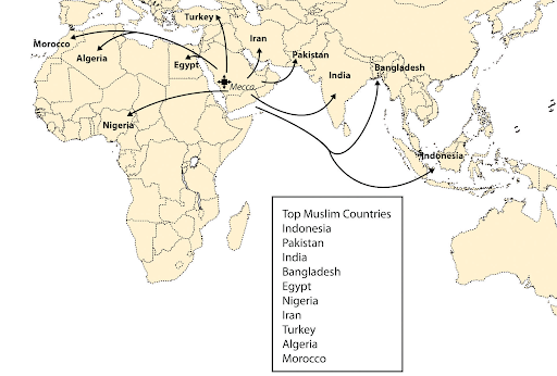
Review:
- Muhammad and Islam
- Faith versus tradition in Islam: Mustafa Akyol's 2011 TEDx Warwick talk
8d. Describe the origin of the African Transition Zone and why it is important
- What role does the Intertropical Convergence Zone (ITCZ) play in the position of the African Transition Zone?
- Why are colonial political borders in conflict with the seasonal shifts in the African Transition Zone?
The African Transition Zone, also known as the Sahel, is a climate phenomenon that shifts depending on the seasons.
- It is where the subtropical high pressure belt, which contributes to the arid conditions of the Sahara Desert, meets the Intertropical Convergence Zone (ITCZ), an equatorial low pressure zone, which makes the tropics wet.
- Because the ITCZ shifts seasonally, the African Transition Zone also shifts.
- In the summer, it shifts north, making the conditions wetter. In the winter, it shifts south, making the conditions drier.
There are variations to this pattern when these high and low pressure belts can stall for other environmental reasons periodically leaving the Sahel with no moisture.
For thousands of years humans in the Sahel have followed the moisture, migrating north in the summer and south in the winter, unencumbered by political borders. When the colonial powers imposed political boundaries on the landscape, they curtailed the movement of these nomads and, in some cases, divided them. Many of the conflicts ongoing in the African Transition Zone can be traced to this clash between traditional practices and interference from outside powers.
Review:
8e. Explain the division between the West Bank, the Gaza Strip, and Israel
- What was Israel called before 1948 and who controlled it?
- What happened to the Palestinians living in Israel when it was officially declared a state in 1948?
- Under the two-state solution, what territory would the State of Palestine include?
Before 1948, the end of the British Mandate, the area that is now the State of Israel was known as Palestine. Given the area's location between the Jordan River and the Mediterranean Sea, Palestine has been a crossroads between the European realm and the North African and Southwest Asian realm. Thus, many powers through the ages have coveted it. The Ottoman Empire controlled Palestine until it was awarded to the British at the close of World War I. The British turned control of Palestine over to the United Nations in 1947.
When the Jewish state of Israel was officially recognized in 1948 following the UN Partition Plan, Palestinians living there were forced to leave their homeland for the designated Arab portion or neighboring Arab countries.
- The Gaza Strip and the West Bank were part of what the UN proposed as an Arab State.
- The Palestinians, with the support of neighboring Arab countries, rejected the UN partition plan, setting off a series of wars in the coming years.
- Through these wars, Israel has been able to expand its territory.
- The Gaza Strip remains under Palestinian control, although trade access is severely limited leading to deteriorating living conditions.
- The West Bank is a complicated landscape of islands of Palestinian control and Jewish settlements.
A two-state solution to the conflict of the area once known as Palestine would consist of two states, the State of Israel and the State of Palestine. The latter would include the Gaza Strip and the West Bank but the specifics of the borders will require intense negotiations.
Review Israel and Its Neighbors.
8f. Describe the physical features of the Arabian Peninsula
- Given that there are no natural lakes or permanent rivers, what are the sources of freshwater on the Arabian Peninsula?
- Where are the Arabian Peninsula's mineral and oil resources found?
The Arabian Peninsula is dominated by type B climates. Like the Sahara Desert of North Africa, the Arabian Desert lies mostly in the tropics, making it a very hot desert.
- Between May and September, the average temperature ranges from 100 to 107° F. The Rub' al-Khali (the Empty Quarter) is too hot and dry even for desert nomads.
- Freshwater on the Arabian Peninsula comes from nonrenewable groundwater and seawater desalination.
- There is runoff from rainfall in the mountains, which is collected in renewable aquifers and ephemeral streams. This surface water is, however, limited to the west and southwest of the Arabian Peninsula.
The Arabian Peninsula's oil fields are in the east and northeast, intersecting Saudi Arabia, Kuwait, Bahrain, Qatar, UAE (United Arab Emirates), Oman, and Iraq. There are oil fields to the south, in Yemen, but the ongoing war has left its fossil fuel deposits untapped. Mineral resources such as copper, gold, and iron ore are found along the west side of the Arabian Peninsula, including the Hijaz and Asir Mountains.
Review The Arabian Peninsula.
8g. Describe the main economic activities of each country within the Arabian Peninsula
- Why do so many foreign workers live in Saudi Arabia?
- Why is Kuwait able to enjoy such a high standard of living?
- How have Bahrain, Qatar, UAE, and Oman facilitated globalization in their countries?
- How has Yemen's economy differed from its neighbors on the Arabian Peninsula?
With the exception of Yemen, oil and gas revenues are vital to the economies of the countries on the Arabian Peninsula. Although Yemen has recently begun to export oil and gas, it was largely dependent on agriculture. Yemen's civil war has, however, curtailed its ability to produce oil and gas. Unlike Yemen, the other countries on the Arabian Peninsula enjoy a high standard of living. Kuwait, for example, uses its substantial oil revenues to benefit its small population through free education.
The thriving oil and gas economies of these countries attract migrants and investment from all over the world.
- Saudi Arabia, for example, has millions of foreign workers in the petroleum industry.
- The influx of foreign workers and investment has influenced some countries' efforts at globalization policies.
- To varying degrees, Bahrain, Qatar, UAE, and Oman have sought to balance their Arab traditions with modernization, such as building shopping malls and resorts, improving infrastructure, and allowing American franchises.
- Some of these countries are diversifying their economies through global banking opportunities, free-trade zones, tourism, and, in the case of Qatar, welcoming a U.S. military installation.
Review Arabs, Islam, and Oil.
8h. Describe the types of governments found in the Arabian Peninsula
- What countries on the Arabian Peninsula are governed by a type of monarchy?
- How does Saudi Arabia differ from other monarchies on the Arabian Peninsula?
- What type of government did Yemen choose following its unification in 1990?
With the exception of Yemen, all of the countries on the Arabian Peninsula have a type of monarchy.
- Yemen is a democracy, although the current governing administration is a provisional one due to the ongoing civil war.
- The Sultanate of Oman is an absolute monarchy, which means one person has complete power and is not restrained by laws or a legislature. In Oman, a hereditary sultan rules the country.
- The Kingdom of Saudi Arabia is also an absolute monarchy but the king must comply with Islamic law (Sharia) and the Koran. The country's constitution consists of the Koran and Muhammad's traditions and practices (Sunnah).
- Kuwait and the Kingdom of Bahrain both have constitutional monarchies. In this form of government, a monarch shares power with a constitutionally organized government that, in the cases of Bahrain and Kuwait, are greatly influenced by the monarch.
- Qatar is a semi-constitutional monarchy, which means that it does have a constitution but that constitution defers to the monarch to the extent that it is closer to an absolute monarchy.
- The United Arab Emirates (UAE) is a federal elective monarchy. Because UAE is a federation of seven emirates, governance occurs through a supreme council composed of the ruling sheiks of each emirate.
Islamic law is, to varying degrees, the source of legislation and governs the legal systems of these countries.
Review Arabs, Islam, and Oil.
8i. Describe women's rights and circumstances in the countries of the Arabian Peninsula
- Although Islam is the dominant religion on the Arabian Peninsula, why do women's rights vary from country to country?
- What is the relationship between women's rights and household size?
Although Islam is the dominant religion in the countries of the Arabian Peninsula, women's rights vary because it is local tradition that curtails their freedom not the doctrine of Islam. Indeed, many women are using Sharia to fight for equality.
- Qatar allows women to vote but traditional interpretations of Islam require women get permission from a male guardian before traveling or gaining access to their children's identification credentials, among many other aspects of their daily lives.
- Bahrain has allowed women to vote since 2002 and allows them to stand for elections.
- Saudi Arabia severely limits the activities of women and segregates the population based on gender.
- The United Arab Emirates provides women more freedom than Saudi Arabia, for example, but male consent is still required for many activities.
- In Kuwait and Oman, women enjoy many freedoms denied women in other Arab countries, including the right to bank and own property, for example. There is, however, still an undercurrent of bias against independent women.
- Although women have full constitutional and legal protection in Yemen, they still struggle to exercise their rights. Patriarchal traditions associated with agrarian and tribal societies, however, persist in Yemen.
Family sizes of the countries on the Arabian Peninsula are all higher than the global average of 4.9. The expectation that the role of women is to bear and raise children continues in these countries, where patriarchal traditions dominate. Thus, household size continues to be inversely related to the rights women have in this region.
Review:
- Arabs, Islam, and Oil
- Faith versus tradition in Islam: Mustafa Akyol's 2011 TEDx Warwick talk
8j. Explain the divisions between each of the major branches of Islam
- What originated the divide in the Islamic faith?
- How does the Sufi branch of Islam differ from the Sunni and Shia branches?
The division of Islam between Sunni and Shia occurred following Muhammad's death because he left no direction for who should carry on his work.
- Muslims who followed Muhammad cousin and son-in-law, Ali, became known as Shia Muslims. Muslims who followed Muhammad's close companion, Abu Bakr, became known as Sunni Muslims.
- This division determines the role the imam, or leader, plays. For Sunni Muslims, the imam leads them in worship, provides religious guidance, and serves as a community leader. For Shia Muslims, the imam has divine knowledge and authority and must be from the lineage of Muhammad.
There are also many smaller branches of Islam, including Sufism, defined as a form of Islamic mysticism. Sufi Muslims focus their thoughts inward so that they can increase their spiritual closeness to God.
Review Muhammad and Islam.
Unit 8 Vocabulary
This vocabulary list includes terms that students need to know to successfully complete the final exam for the course.
- absolute monarchy
- African Transition Zone (Sahel)
- Arab Spring
- Arab State
- Arabian Peninsula
- Arabian Desert
- Asir Mountains
- Atlas Mountains
- British Mandate
- constitutional monarchies
- democracy
- ephemeral streams
- federal elective monarchy
- Gaza Strip
- highlands
- Hijaz Mountains
- imam
- Iranian Plateau
- Islam
- Islamic law (Sharia)
- Israel
- Intertropical Convergence Zone (ITCZ)
- Jewish settlements
- Jordan River
- Koran
- Libyan Desert
- Mediterranean Sea
- monarchy
- monotheistic
- Mountains of Central Asia
- Muhammad
- nonrenewable groundwater
- Nubian Desert
- Ottoman Empire
- patriarchal traditions
- renewable aquifers
- Rub' al-Khali
- Sahara Desert
- seawater desalination
- semi-constitutional monarchy
- Shia Muslims
- spatial diffusion
- Sufism
- Sunni Muslims
- two-state solution
- type B climates
- type C climates
- type H climates
- United Nations
- West Bank
Unit 9: South Asia
9a. Summarize the physical geography of South Asia
- What is the topographic relief of South Asia?
- How does precipitation vary across South Asia?
- What features connect the Himalayas to the Arabian Sea and the Bay of Bengal?
The topographic relief and variation in precipitation of South Asia are both dramatic.
- The topographic relief of South Asia is the difference between Mount Everest, the highest elevation at 29029 feet, and Maldives, the lowest elevation at less than 1 feet, in the region. With Mount Everest the highest point on Earth and the Maldives the country with the lowest elevation on Earth, South Asia's relief is particularly notable.
- The variation in precipitation is similarly dramatic, with deserts in India and Pakistan and monsoon conditions in India, Sri Lanka, Bangladesh, and Myanmar. The two rainiest places on Earth are both in India along the northeast border of Bangladesh, the country with the tenth highest average annual precipitation.
The dramatic nature of this realm includes hazards in the form of earthquakes and flooding.
In addition to its topographic and precipitation superlatives, South Asia also has some of the world's most famous rivers.
- The Indus River rises in the Himalayas and empties into the Arabian Sea near Karachi, Pakistan and has been a center of human civilization for thousands of years. The Indus River is sacred to Hindus.
- The Ganges River also rises in the Himalayas and empties into the Bay of Bengal and is the third largest river in the world, after the Amazon and Congo Rivers, in terms of discharge. The Ganges is the most sacred river to the Hindus.
In addition to their religious importance, these rivers are vital to the physical survival of Pakistanis, Indians, and Bangladeshis.
Review Introducing the Realm.
9b. Explain the dynamics of the monsoon and how it affects human activities
- How is the monsoon related to the Intertropical Convergence Zone (ITCZ)?
- Why are human populations so vulnerable to the effects of monsoonal precipitation?
- Why are the effects of monsoonal precipitation more devastating when there has been a drought?
Monsoons are seasonal winds that bring heavy rains in the summer but leave the landmass dry in the winter. In the realm of South Asia, when the Intertropical Convergence Zone (ITCZ) migrates north in the summer, moisture-laden air from the Indian Ocean is drawn to the warmer landmass. Thus, these monsoonal winds bring heavy rains in the summer. When the ITCZ migrates south in the winter, the winds reverse and blow from the cooler landmass to the warmer ocean.
Monsoons bring heavy rains that cause flooding. Because humans tend to live along rivers for access to water and fertile soil, they are vulnerable when these rivers flood. Every year, monsoonal rains and the ensuing floods displace people, destroy infrastructure, and increase the prevalence of water-borne diseases. If drought conditions precede the rainfall, flooding occurs sooner because the rain runs off the dry, crusty surface directly into streams and rivers. When soils are dry, it takes longer for water to infiltrate the surface.
Review:
- Introducing the Realm: the section titled The Monsoon
- Indian Monsoon
9c. Describe how European colonialism has affected South Asia
- Why did the British Empire withdraw from South Asia in 1947?
- Describe how the British partition of India resulted in the sovereign states of Bangladesh and Pakistan.
- What evidence is there for the British Empire's influence on daily life in India and Pakistan?
The British Empire colonized most of South Asia. Through the trade activities of the British East India Company, Britain began establishing colonies in 1857. By 1947, the British Empire was no longer able to maintain control due to local resistance and the effects of involvement in World War II, which required substantial resources for rebuilding Great Britain at home. As the British withdrew, they partitioned British India into India and Pakistan based on religious differences.
- India was to be home to the Hindu population, and Pakistan was to be home to the Muslim population.
- Pakistan was divided between two areas. West Pakistan was carved out of west India, and East Pakistan was carved out of east India; 1,000 miles of India separated them.
- When the partition occurred, many Hindus were left in Pakistan and many Muslims were left in India
- War broke out because the newly formed governments of Pakistan and India were unable to manage the mass migration of people attempting to reach their country of choice.
- Relations between West and East Pakistan were strained from the outset because their cultural differences exceeded the similarity of a shared religion.
- War eventually broke out between the two, resulting in a new sovereign state. The western portion of Pakistan remained Pakistan and the eastern portion became Bangladesh.
Beyond their impact on the political boundaries of South Asia, Great Britain also made a lasting impact on the languages of Pakistan and India. English remains one of the two official languages in each country. Although English remains a lingua franca in Bangladesh, it is not an official language.
Review the section titled Colonialism in South Asia in Introducing the Realm.
9d. Explain why rapid population growth is a concern for the countries of South Asia
- Why is physiologic density an important indicator of a country's economic development?
- How does the doubling time of a population relate to its economic prospects?
High population growth is straining the resources of South Asia. From water to education, there is not enough to meet the needs of the people.
- The population density, the number of people per square mile, of these countries is staggering, with many people living in overcrowded conditions.
- The physiologic density, the number of people per square mile of arable land, of these countries is even higher.
- Deserts and mountainous terrain dominate the physical landscapes of many of these countries so the arable land is limited to river valleys and lowlands,
- In addition to physical geography, other countries, such as Bhutan and the Maldives, are limited by geographic area.
These countries continue to grow to the point that South Asia's population will double in about fifty years. The lower the doubling time, the more difficult it is for a country to transition through the stages of economic development.
Review the section titled Population in South Asia in Introducing the Realm.
9e. Discuss how and why Kashmir is divided and its importance to the region
- What is the strategic value of the remote region of Kashmir to India, Pakistan, and China?
- What religions are represented by the people of Kashmir?
The dispute resulting in the current division of Kashmir began during the British Partition of 1947.
- Both India and Pakistan claimed the region, which was home to a majority Muslim population yet ruled by a Hindu minority.
- The Muslim population sought protection from Pakistan. The ruling Hindu minority initially sought independence for Kashmir but turned to India at the prospect of control by Pakistan.
- Pakistan and India continued to fight for the region until the United Nations mediated the Line of Control. Pakistan was given control of the northwest portion and India the southern portion.
- China controls the eastern portion and does not consider it part of Kashmir.
Kashmir is of value to these countries because of its glaciers and freshwater. India is designing hydroelectric projects for the rivers in the portion of Kashmir it controls, which would reduce the flow of freshwater to Pakistan. The Kashmir region is important to both the Hindu and Buddhist religions.
Review The Peripheral States of South Asia.
9f. Summarize the main environmental concerns of the states of South Asia
- How did the former president of Maldives plan to protect the people as sea level rises?
- What is the environmental impact of population on Nepal's physical landscape?
- What measures has Bhutan implemented to protect its natural environment?
The peripheral countries of South Asia face a variety of environmental challenges.
- As the lowest-lying country on Earth, Maldives is at risk of inundation by the Indian Ocean as sea level rises. In 2008, the president at the time began looking into purchasing land in India, Sri Lanka, and Australia to relocate the population. Rather than relocating the population, the current administration is seeking funding for sea walls.
- Nepal's increasing population is straining natural resources. Deforestation and soil erosion are on the rise as land is cleared for agricultural production to accommodate the growing population. Nepal also suffers from the environmental damage tourists cause at its many natural and cultural attractions.
- Bhutan has a "High Value, Low Impact" policy to minimize the impact of tourism on its natural environment. It limits the number of tourists in the country at a time and requires tourists to use a registered tour operator and purchase a minimum daily package.
- In addition to the environmental impact of war, Sri Lanka is experiencing deforestation and the degradation of its mangroves and coral reefs. As an island, it is also vulnerable to sea level rise.
Review The Peripheral States of South Asia.
9g. Outline the main environmental issues that confront Pakistan and Bangladesh
- How has population growth contributed to the environmental issues that confront Pakistan and Bangladesh?
- Why do summer monsoonal rains exacerbate water pollution in Pakistan and Bangladesh?
Pakistan's and Bangladesh's resources are being depleted as their populations continue to grow. As two of the most densely populated countries in the world, arable land in Pakistan and Bangladesh is at a premium. Deforestation is widespread to clear land for crops and housing. Drinkable freshwater is another valuable resource that is increasingly scarce as the population grows.
Population growth also strains the existing water distribution and sewage infrastructure resulting in the discharge of pollutants into waterways. The summer rains brought by monsoons exacerbate the problem because water levels rise and rivers overflow their banks, carrying sewage and other pollutants into drinking water supplies. Waterborne diseases increase and ecosystems are contaminated.
Review Pakistan and Bangladesh.
9h. Discuss the history of why East Pakistan became Bangladesh
- How did East Pakistan differ from West Pakistan?
- Explain the role the 1970 Bhola cyclone played in the emergence of Bangladesh as a sovereign state.
Although separated by 1,000 miles, the east and west portions of Pakistan were both governed from the west. Those living in East Pakistan were culturally different and often felt ignored by West Pakistan. Although both shared the religion of Islam, the differences were too great to overcome.
- The population of the area designated as East Pakistan is predominantly Bengali, a language and cultural designation for the people of Bengal, the region around the Bay of Bengal.
- Because Pakistan was administered from West Pakistan, Urdu was chosen as the national language, which further alienated East Pakistan.
Bengali nationalism peaked following the catastrophic 1970 Bhola cyclone, which struck East Pakistan and killed 500,000 people. East Pakistan resented the inadequate support from the federal government, located in West Pakistan, in the aftermath of the disaster. The ensuing struggle for independence resulted in the new sovereign state of Bangladesh in December of 1971.
Review Pakistan and Bangladesh.
9i. Summarize the main economic activities and economic conditions in India
- What role has the government played in India's economic development?
- What are the key sectors in India's economy?
- Describe how rural and urban life in India relates to the economic conditions.
India has a mixed economy, a mixture of a capitalist economy and a socialist economy. India's government has, since its independence, played a substantial role in the economy, which is the socialist element. It has, however, begun to let the market play a larger role, which is the capitalist element. By diversifying its economy, India was one of the fastest growing economies in the world in 2019.
- Although agriculture still accounts for slightly more than half the workforce, jobs in construction and manufacturing are increasing. Vehicle manufacturing, for example, is rapidly expanding.
- Information technology and related services have grown substantially as a percentage of India's Gross Domestic Product (GDP).
- India's major industries include textiles, pharmaceuticals, chemicals and petrochemicals, and engineering, among others.
- Tourism, entertainment, telecommunications, retail, healthcare, and many other services are all part of India's success at diversifying its economy.
Despite India's economic success, as the second most populated country in the world, most of its citizens are desperately poor. There is an enormous gap between those living in rural areas who subsist on agriculture, and the middle class who live in urban areas, working in the manufacturing and service sectors. That gap extends to the urban poor who migrate to cities seeking jobs and better living conditions, but find themselves eking out a living in the slums.
Review India.
9j. Describe how British colonialism affected India
- What was the problem with the railroad system the British colonists built in India?
- Why did the British move their colonial capital from Kolkata, on the Bay of Bengal, to New Delhi, in the country's interior?
In addition to language and borders, the British colonists left behind a railroad system and a series of port cities. The British built the railroad to transport the resources they extracted to the port cities where they could be shipped to Great Britain. Thus, the railroad consisted of individual lines that connected the extraction site to the coast rather than an integrated network.
The British, through the East India Company, developed three major port cities from which to send and receive goods by ship. These cities were spread out along the Indian coast.
- Mumbai (Bombay), on the west coast, provided access to the Arabian Sea.
- Chennai (Madras), on the southeast coast, provided access to the lower Bay of Bengal.
- Kolkata (Calcutta), on the lower Ganges Delta along the northeast coast, provided access to the upper Bay of Bengal. Kolkata was the capital until 1911, when the British moved it to New Delhi.
The British moved the capital city for several reasons. Kolkata was the site of nationalist movements and anti-colonial sentiment including assassinations of British officials. New Delhi was chosen for its more central location, making it easier to administer the entire country.
Review India.
9k. Discuss the religions of South Asia and India, specifically the origin and migration of Buddhism
- What are some of the similarities and differences between Hinduism and Buddhism?
- How do the geographic branches of Buddhism vary?
- Of the religions practiced in South Asia, which ones originated there?
- Where, in South Asia, is Islam the dominant religion?
The dominant religions in South Asia are Buddhism, Hinduism, and Islam. Buddhism is the dominant religion in Bhutan and Sri Lanka. Hinduism is the dominant religion in India and Nepal. Islam is the dominant religion in Bangladesh, Maldives, and Pakistan. Of these, Hinduism and Buddhism, in addition to Sikhism and Jainism, originated in South Asia. Hinduism and Buddhism both originated in northern India and are the world's third and fourth largest religions, respectively. Hinduism has been practiced in some form for over 4,000 years, whereas Buddhism originated about 2,500 years ago. Hindus and Buddhists use some of the same basic vocabulary and have some similarities in terms of symbolism and practices. There are, of course, substantial differences. Below are a few examples:
- Hindus do not have a single founder.
- Buddhists renounce the caste system.
- Hindus worship deities and have the concept of a soul, but Buddhists do not.
- Buddhists do not recognize a God. Instead, they show reverence and devotion to the Buddha.
As Buddhism spread from northern India, different variations developed according to geography, what teachings were followed, and how monks were ordained, among other factors.
- The northern branch, Vajrayana Buddhism, is often called Tibetan Buddhism.
- The southern branch, Theravada Buddhism, is sometimes called Southern Buddhism.
- The eastern branch, Mahayana Buddhism, is often referred to as East Asian Buddhism.
Regardless of the focus of each branch, all hold to the Four Noble Truths and the Eightfold Path taught by the Buddha.
Review Religions of India and South Asia.
Unit 9 Vocabulary
This vocabulary list includes terms that students need to know to successfully complete the final exam for the course.
- Arabian Sea
- Bangladesh
- Bay of Bengal
- Bengali
- British East India Company
- British Empire
- British Partition of 1947
- Buddhist
- capitalist economy
- caste system
- Chennai (Madras)
- Christianity
- deforestation
- drought
- doubling time
- East Pakistan
- extraction site
- flooding
- freshwater
- Ganges River
- Himalayas
- Hindu
- India
- Indian Ocean
- Indus River
- integrated network
- Intertropical Convergence Zone (ITCZ)
- Islam
- Jainism
- Kashmir
- Kolkata (Calcutta)
- Line of Control
- mass migration
- mixed economy
- monsoons
- Mumbai (Bombay)
- Muslim
- New Delhi
- Pakistan
- physiologic density
- population density
- port cities
- Sikhism
- soil erosion
- South Asia
- socialist economy
- topographic relief
- Urdu
- West Pakistan
- 1970 Bhola cyclone
Unit 10: East Asia
10a. Identify the countries and territories of East Asia
- What East Asian countries share a border with China?
- What East Asian countries have a coastline on the Sea of Japan?
- What East Asian countries are islands?
- What other realms influence Mongolia and the Autonomous Region of Tibet?
China, the most populous country in the world, dominates the realm of East Asia. It borders only two other East Asian countries, Mongolia and North Korea. Across the Yellow Sea from northeast China, North Korea and South Korea form the Korean Peninsula. North Korea, South Korea, and Japan surround the Sea of Japan. East Asia has two island countries, Taiwan and Japan, which includes five main islands and thousands of smaller ones. As landlocked peripheral areas, the country of Mongolia and the Autonomous Region of Tibet are influenced by their neighboring realms. The Russian realm has influenced Mongolia and the South Asia realm has influenced the Autonomous Region of Tibet.
Review:
10b. Describe the physical features and climates of each country
- What impact do the Himalaya Mountains and the Tibetan Plateau have on the physical geography of China and Mongolia?
- Why is Japan prone to earthquakes?
- How does Taiwan's climate compare to Japan's?
- What two climate types are found on the Korean Peninsula?
Due to its proximity to tectonic plate boundaries, the realm of East Asia experiences both earthquakes and volcanoes and includes some of the most dramatic landscapes.
- The Himalaya Mountains and the Tibetan Plateau are the result of the collision between the Indian tectonic plate and the Eurasian tectonic plate. Their influence extends beyond that collision zone into central and eastern China and southern Mongolia.
- The Himalaya Mountains prevent moisture-laden air from reaching the Gobi Desert, which straddles China and Mongolia. This rain shadow effect, along with the distance from the Indian Ocean, makes the Gobi territory a desert.
- The headwaters of the Yangtze (Yangzi) and Yellow (Huang He) Rivers are found in the Tibetan Plateau; they are the third- and sixth-longest rivers in the world, respectively.
- The islands of Japan are volcanic islands at the intersection of four tectonic plates and part of the Ring of Fire. Thus, Japan is prone to earthquakes, tsunamis, and volcanic eruptions.
Although both Taiwan and Japan are islands, their climate varies due primarily to their latitudinal differences. Taiwan's latitude ranges from 21°N to 26°N with a humid subtropical (type C) climate that becomes tropical (type A) in the south. Japan's latitude ranges from 24°N to 45.5°N with a cold (type D) climate in the north and a humid subtropical (type C) climate in the south. Across the Korea Strait, the Korean Peninsula has a similar climate range as Japan, cold (type D) in the north and temperate in the south (type C).
Review:
- Introducing the Realm: East Asia
- Japan and Korea (North and South)
- China's Periphery: the section on Mongolia
- Ring of Fire
10c. Analyze the relationship between physical geography and human populations in East Asia
- Explain why most of China's population lives in the eastern region known as China Proper?
- What feature of the physical landscape explains the population distributions of Japan and Taiwan?
- What advantages does South Korea's physical landscape have over North Korea's in terms of human habitation?
China extends from below the Tropic of Cancer at approximately 18°N to 53°N latitude. This wide range of latitude in combination with a long coastline and a large landmass means China has many different climates. As is often the case, most of the population of China lives in the east along the coast because the climates are temperate (type C), the soils are good, and there is adequate freshwater. The population is also clustered along the major rivers that flow into China Proper.
Terrain plays a significant role in the distribution of population in Japan and Taiwan, and puts South Korea at an advantage over North Korea. Rugged mountains are prevalent in these countries, so the population and economic activity is found along the coasts, on the plains, and in the valleys.
- In Japan, most of the population lives along the low-lying southern coast of Honshu island. This is known as the Core Region and stretches from Tokyo in the east to Hiroshima in the west and onto the northern part of Kyushu island.
- The majority of Taiwan's population lives on the flat and rolling plains along the west coast of the island. There are forest-covered mountain ranges that dominate the eastern two-thirds of the island.
- Although the Korean Peninsula is mountainous, South Korea has more low-lying, flat land that can be cultivated than North Korea. North Korea's agricultural efforts are further challenged by a colder climate.
Review Introducing the Realm: East Asia.
10d. Describe how colonialism affected China
- Why did China pose a greater challenge to colonizers than other countries?
- How did British colonizers use opium to gain the upper hand in China?
- What was the extent of colonization by other European powers?
European colonizers did not have the advantages over China that they did with other places. China was more technologically advanced than other societies.
- They already recognized the necessity of clean water to avoid the spread of disease.
- They had established transportation networks and were using paper and gunpowder before they arrived in Europe.
The Industrial Revolution, however, soon gave Britain an advantage. They were able to produce goods more quickly than the Chinese.
The British also resorted to increasing the availability of opium so that it was accessible throughout Chinese society.
- The Chinese government sought to counter the effects of opium on the population by destroying it.
- The British demanded compensation for the lost opium, leading to the Opium Wars from which Britain emerged with the upper hand.
Other countries also had a colonial presence in China. Portugal actually predated the British, renting the island of Macau from China to use as a trading post until gaining full colonial control following the Opium Wars. Germany, France, Japan, and Russia also had a colonial influence on China.
Review the section titled Chinese Dynasties and Colonialism in Introducing the Realm: East Asia.
10e. Discuss the three-way split in China
- What factions were parties involved in the struggle to control China following World War I?
- How did World War II change the struggle for power in China?
Although the European colonizers were less involved in China as they worked to recover from the effects of World War I, Japan continued to expand its influence in the country. In addition to the Japanese, two factions within China sought control, the Nationalists and the Communists. The Chinese people wanted them to work together to defeat the Japanese, but it was not until Japan's defeat in World War II that the Japanese left China. Eventually, the Communists defeated the Nationalists, who fled to Formosa (Taiwan). The Communists claimed the mainland as the People's Republic of China and the Nationalists claimed Taiwan as the Republic of China.
Review the section titled Three-Way Split in China in Introducing the Realm: East Asia.
10f. Describe China's transition from communism to a capitalist-influenced economy
- Distinguish between a command economy, a market economy, and the type of economy China has.
- What has the growth in China's economy meant for its people?
China's transition from a command economy, also known as a planned economy, began after the death of Mao Zedong and the end of the Cultural Revolution in 1976. Under Chairman Mao, the government controlled all aspects of China's economic activity, including production, investments, prices, and incomes. Mao's successor, Deng Xiaoping, started opening China's economy to undo the damage of such programs as the Great Leap Forward, which devastated China's population. This has been a gradual process that has been ongoing since 1978.
- The government disbanded communes and relaxed restrictions on people's personal lives.
- Deng Xiaoping established Special Economic Zones like Shenzhen, which were opened for foreign investment to spur economic growth for the country.
- In the 1980s, the government began to decentralize controls and privatize some state enterprises.
- In the 1990s, the government reduced tariffs and regulations and joined the World Trade Organization (WTO).
- Since the mid-2000s, China's government has favored more state control, although its economy remains market-oriented.
As a market-oriented economy, China is in between a command economy and a market economy, which means private businesses compete to determine production and prices. China's economy, also known as a socialist market economy, leans toward public ownership and state-owned enterprises within a market economy. Although the standard of living for most Chinese has improved since before reforms began, income inequality has dramatically increased.
Review:
- Emerging China
- Understanding the Rise of China: Martin Jacques' 2010 TEDSalon talk
- A Tale of Two Political Systems: Eric X. Li's 2013 TEDGlobal talk
10g. Analyze the One Child Only Policy and discuss its effect on Chinese culture
- Why did the government implement the one-child policy in 1978?
- Why does China have more males than females than is the global average?
In 1978, China began the one-child policy to control the size of its rapidly growing population. The government was concerned about the environmental, economic, and social problems associated with overpopulation. Although the policy has limited population growth, it has had troubling consequences. Because Chinese culture values male children over female children, sex-selective abortions, female infanticide, and the abandonment of female children increased. The result has been a sex ratio disparity; there are now more males than there are females. According to the CIA's World Factbook, the global average ratio of males to females aged 15 to 24 was 1.07 in 2020. In China, there were 1.17 males per female in 2020.
Review the section titled The People in Emerging China.
10h. Explain Hong Kong's progression from a British colony to a special autonomous region of China
- How did the British acquire Hong Kong?
- What were the conditions of the transfer of Hong Kong to China at the end of the lease?
The Qing Empire ceded Hong Kong Island to the British as one of the conditions of the 1842 Treaty of Nanking (Nanjing), ending the First Opium War. The colony of Hong Kong expanded to include Kowloon Peninsula and Stonecutters Island in 1860 following the Second Opium War. In 1898, the British expanded its colony when it obtained a 99-year lease of the New Territories, which included the area to the north of Kowloon and the outlying islands of Lantau and Lamma, among others.
As the end of the lease approached, Britain negotiated with China to extend Hong Kong's political and economic status for another fifty years. Thus, when Britain transferred Hong Kong to China in 1997, the area became a Special Administrative Region of the People's Republic of China. It is, at least until 2047, administered separately from mainland China under the principle of one country, two systems.
Review:
10i. Describe the relationship between Taiwan and mainland China
- What is the "One China" policy?
- Regarding Taiwan, what conditions did China impose on the United States when diplomatic relations opened in the 1970s?
The People's Republic of China (PRC) asserts that there is only one sovereign state that can use the name China and are, therefore, opposed to Taiwan's use of the Republic of China (ROC). Neither the PRC nor the ROC considers the other to be the legitimate national government. The PRC believes Taiwan is part of China's territory and must be reunified with the mainland.
In order to engage in diplomatic relations and eventually trade with China, the United States had to acknowledge its One China Policy, significantly changing its official stance on Taiwan.
- The U.S. moved its embassy from Taipei to Beijing.
- U.S. State Department officials with a cabinet level position or higher cannot formally visit Taiwan, and equal level officials from Taiwan cannot visit the U.S. in a formal capacity.
- The U.S. does maintain economic and cultural ties with Taiwan.
In order to be recognized internationally, Taiwan often uses the ambiguous name of Chinese Taipei.
Review:
10j. Explain the challenges that Tibet has experienced in becoming an autonomous region of China
- What type of government did Tibet have prior to incorporation into the People's Republic of China?
- Explain the core-periphery relationship between China and Tibet.
- How is China shifting the ethnic balance of Tibet?
Historically, Tibet has been an independent theocracy, with the Dalai Lama as both the head of state and the spiritual leader. Tibet has, however, been under China's control since 1950. Although it is considered one of China's autonomous regions, in practice, Tibet has very little autonomy. The Dalai Lama has been in exile in India since 1950, and China abducted the Panchen Lama in 1995.
China's interest in Tibet is strategic both geographically and economically. Tibet buffers China from India and it has valuable resources. As the rural periphery to China's urban core, Tibet can provide minerals, energy resources, and timber for China's further industrial development. As China moves raw materials east, it is bringing its people west. Facilitating the movement of ethnic Chinese to Tibet further strengthens China's hold on Tibet by diluting its native population.
Review China's Periphery.
10k. Discuss the economic development of Japan
- Explain Japan's ability to go from the devastation of World War II to its position as an economic superpower.
- What are the centripetal forces that contribute to Japan's economic growth?
- With so few natural resources, how can Japan be so successful economically?
There are numerous factors involved in Japan's ability to rebuild its economy so quickly following the devastation of World War II.
- It was already an industrialized society before the War.
- The United States provided support to rebuild infrastructure.
- Japan's centripetal forces outweigh the centrifugal forces.
- Japan undertook major economic reforms.
- The U.S. need for materials to participate in the Korean War stimulated Japan's economy.
These, in addition to other factors, worked together in Japan's favor, resulting in a significant improvement in its standard of living within thirty years.
As is the case in Taiwan, Japan has little in the way of natural resources yet it is a dominant economic power.
- There is no one explanation for this disparity, but centripetal forces likely contribute to economic success. For example, Japan is a nation-state. As a population with a common heritage and shared aspirations, it is not divided by competing interests.
- Japan has also been remarkably successful in its ability to manage labor and resources. Its workforce is highly skilled and educated, savings rates and investment are generally high, and corporations took advantage of economies of scale.
Japan's economic success is closely associated with its reputation for high-quality, durable manufactured goods.
Review Japan and Korea (North and South).
10l. Discuss the political structure of North Korea
- What countries' governmental structures influenced North Korea's when it was formed?
- Describe the conditions under which North Koreans live.
The authoritarian style governments of China and the USSR influenced Kim Il Sung's formation of North Korea's government in 1948. North Korea continues to have a government in which the power resides with a single person, the country's citizens have no say in the process, and there is no independent media.
- Although it is a communist country, the state does not provide education, healthcare, or jobs. Students, for example, must pay their teachers in goods that can be sold at market in order to attend school.
- There is intermittent or no access to electricity and running water. Even the elites living in the capital city of Pyongyang may experience outages.
- Food, particularly in the form of protein, is scarce. There was mass starvation during a period of famine from 1994 to 1998.
North Korea's government isolates its population from the rest of the world both physically and through propaganda. Although mobile phones are permitted, they cannot be used to dial out of the country nor can they access the Internet.
Review:
10m. Discuss South Korea's economy
- What type of economy does South Korea have?
- What are South Korea's major economic sectors?
- How do income levels in South Korea differ from North Korea?
South Korea has a mixed economy. It has blended aspects of a free-market economy with a state-planned economy to grow from one of the poorest countries in the world following the Korea War to become the 10th largest in the world in 2020. Like Japan, South Korea undertook aggressive economic reforms focused on an export-oriented strategy, importing only raw materials. South Korea also invested heavily in education. Its workforce is highly skilled, which has spurred its growth in technology exports. South Korea's major economic sectors include shipbuilding, automobile manufacturing, and electronics. Incomes in South Korea are very high compared to North Korea's.
Review Japan and Korea (North and South).
Unit 10 Vocabulary
This vocabulary list includes terms that students need to know to successfully complete the final exam for the course.
- authoritarian style governments
- Autonomous Region of Tibet
- centrifugal forces
- centripetal forces
- China
- China Proper
- command economy (planned economy)
- communist
- Communists
- core region
- Cultural Revolution
- Dalai Lama
- Deng Xiaoping
- earthquakes
- free-market economy
- Gobi Desert
- Himalaya Mountains
- Hiroshima
- Honshu
- Industrial Revolution
- industrialized society
- Japan
- Korea Strait
- Korean Peninsula
- Korean War
- Kyushu
- landlocked peripheral areas
- Mao Zedong
- market economy
- mixed economy
- Mongolia
- Nationalists
- nation-state
- New Territories
- North Korea
- one-child policy
- One China policy
- Opium Wars
- overpopulation
- Panchen Lama
- People's Republic of China (PRC)
- propaganda
- Pyongyang
- Qing Empire
- Republic of China (ROC)
- Ring of Fire
- rural periphery
- Sea of Japan
- sex ratio disparity
- Shenzhen
- Special Administrative Region
- socialist market economy
- South Korea
- Special Economic Zones
- state-planned economy
- Taiwan
- tectonic plate boundaries
- theocracy
- Tibet
- Tibetan Plateau
- Tokyo
- Tropic of Cancer
- tsunamis
- urban core
- volcanic eruptions
- World Trade Organization (WTO)
- Yangtze (Yangzi) River
- Yellow (Huang He) River
- Yellow Sea
- 1842 Treaty of Nanking (Nanjing)
Unit 11: Southeast Asia
11a. Describe the geographical differences between the mainland and insular regions of Southeast Asia
- What feature separates the mainland and insular regions of Southeast Asia?
- What distinguishes Laos from the other countries of mainland Southeast Asia?
- What makes it more challenging to govern some of the insular countries in contrast to the mainland countries?
The South China Sea separates the mainland and insular regions of Southeast Asia. The mainland region of Southeast Asia includes Vietnam, Cambodia, Thailand, Myanmar (formerly Burma), and the landlocked country of Laos. The insular region includes Malaysia, Singapore, Indonesia, Brunei, Philippines, and Timor-Leste (East Timor). Both regions are predominantly tropical. The insular region is particularly vulnerable to the hazards associated with tectonic activity.
Three of the countries in the insular region span numerous islands and, in the case of Malaysia, straddle the mainland and insular regions. Malaysia extends from the Malay Peninsula in the west, across the South China Sea, to the island of Borneo in the east. Indonesia is the world's largest island country and includes over seventeen thousand islands. The Philippines includes over 7,500 islands. Given the challenges associated with governing a country separated by large bodies of water, some countries such as Indonesia have chosen to grant some provinces more autonomy.
Review the section on Physical Geography in Introducing the Realm.
11b. Summarize how Southeast Asia was colonized
- What European and East Asian powers colonized the realm of Southeast Asia?
- Although it was not colonized, how did France and Britain use Thailand?
The potential for trade motivated Portugal and Spain to reach Southeast Asia in the sixteenth century, followed by the Netherlands, Britain, and France. Japan sought more territory for its population, occupying much of Southeast Asia during World War II including Thailand, which was not colonized by European powers. Although Britain controlled Myanmar to the west and France controlled Cambodia, Vietnam, and Laos to the east, Thailand was left as a buffer between the two.
There is evidence today of the influence of colonial powers in the realm of Southeast Asia in the following examples.
- English is a recognized language in Malaysia and an official language in Singapore, both former British colonies.
- Many buildings in Vietnam's cities are in the French architectural style.
- Catholicism, which the Spanish and Portuguese brought, is still the dominant religion of the Philippines and Timor-Leste, respectively.
- French remains one of the spoken languages in Laos, and Portuguese is an official language in Timor-Leste.
- There are a number of Dutch words that were adopted by Indonesians and continue to be used.
Review the section on Impact of Colonialism in Introducing the Realm.
11c. Describe the diversity of ethnic and religious affiliations of Southeast Asia
- What country is home to the largest population of Muslims in the world?
- What religion dominates the mainland region of Southeast Asia?
- Why does the diversity of ethnicities continue to thrive in the insular region of Southeast Asia?
Muslim traders from the Arabian Peninsula likely brought Islam to Indonesia prior to European colonization through spatial diffusion. Islam is also the dominant religion of Malaysia. Sunni Islam is the most common form practiced in these countries. Buddhism is the most commonly practiced religion among the people of the mainland region. These countries practice Theravada Buddhism, which is sometimes called Southern Buddhism, and is also practiced in Sri Lanka, a country in the realm of South Asia.
Globalization has blurred the differences between cultures as it becomes easier to move from one location to another regardless of distance. The insular region of Southeast Asia remains one of the exceptions. It is more difficult to move from island to island than it is to move within a large landmass. Thus, differences are more likely to remain intact and even increase. Diversity can, however, also thrive on a single island due to barriers in the physical geography, which can prevent movement. For example, the island of New Guinea, with the western portion under Indonesian control, is home to hundreds of ethnic groups.
Review the section on Cultural Introduction in Introducing the Realm.
11d. Explain the influence of overseas Chinese people in Southeast Asia
- Why are there more overseas Chinese in Southeast Asia than any other realm?
- What role have overseas Chinese played in the economic development of Southeast Asian countries?
Due to Southeast Asia's proximity to China, it is not surprising that more overseas Chinese live there than anywhere else. For example, more than 75% of Singapore's population and almost 25% of Malaysia's population are ethnically Chinese. Many Chinese fled the political division on mainland China between 1912 and 1949. The overseas Chinese population has maintained ties to their homeland, making economic connections possible in the age of globalization. Their ability to communicate in the languages of their homeland and their adopted country facilitates business opportunities.
Review the section on Overseas Chinese in Introducing the Realm.
11e. Describe how Vietnam was divided by civil war and the effect the war had on the country
- What prevented Vietnam from unifying under one government in the mid-1950s?
- Why did the United States choose to intervene in Vietnam?
- Describe Vietnam's economic development since the war.
As a site of competing colonial interests, Vietnam had long been pulled in different directions. By the time Vietnam defeated the French, there were, understandably, competing visions for how to move Vietnam forward, thus, preventing unification.
- To the north, a Communist ideology was gaining traction, whereas to the south, the preference was for democracy and a free-market economy.
- The international community picked sides, escalating the stakes in the war between the Communist faction in the north, supported by the USSR, and the non-Communist faction to the south, supported by the United States.
- The United States and its allies feared the spread of Communism, the domino theory; if Vietnam fell, so would its neighbors.
The Vietnam War lasted twenty years, ending in 1975 with the North Vietnamese taking Saigon (now Ho Chi Minh City), the capital of South Vietnam. In 1976, North and South Vietnam became the Socialist Republic of Vietnam.
Since the war, Vietnam has recovered slowly. It has a mixed economy, with the government playing a key role in the country's economic development. Although Vietnam remains largely engaged in primary and secondary sector activities, it is undergoing a rural-to-urban migration shift with more tertiary sector activities including tourism. Its neighbors in the East Asian realm have turned to Vietnam as a source of cheap labor.
Review the section on Vietnam in The Mainland Countries.
11f. Explain how the rural, landlocked country of Laos is addressing its economic situation
- What features dominate Laos' physical landscape?
- How is Laos able to improve its infrastructure?
Laos is a country of rugged, forested mountains and the only landlocked country in the realm of Southeast Asia. The Mekong River forms much of Laos' western border. Thus, most people live there to take advantage of the low relief and agricultural potential of the floodplain. The Mekong links Laos to the outside world and has tied it closely to its western neighbor, Thailand.
Although the Mekong mitigates some of Laos' isolation beyond its borders, connections within its borders are poor. The Vietnam War damaged what little infrastructure Laos had. The World Bank, among other organizations, is supporting Laos' efforts to improve electrical, water, sanitation, and communication infrastructure. China is helping Laos to increase rail access throughout the country.
Review the section on Laos in The Mainland Countries.
11g. Describe the conditions that led to the creation of Democratic Kampuchea
- How did the Vietnam War contribute to the Khmer Rouge's rise to power in Cambodia?
- What role did China play in Democratic Kampuchea?
Cambodia was caught up in the Vietnam War due to its proximity to Vietnam. The Khmer Rouge, a Cambodian rebel faction espousing Communist ideology, gained the support of the Vietnamese communists to overthrow the government. Thus, the Khmer Rouge took advantage of the chaos of the Vietnam War to seize control of Cambodia. Phnom Penh, the capital of Cambodia, fell to the Khmer Rouge shortly after the United States withdrew from Cambodia in 1975. Pol Pot, the leader of the Khmer Rouge, renamed Cambodia Democratic Kampuchea in 1976.
China's disastrous Great Leap Forward program inspired Pol Pot's vision for Democratic Kampuchea. When the Khmer Rouge took control, the cities were evacuated and the residents forced to live in the countryside to create an "agrarian utopia". Under Pol Pot's three-year reign of terror, intellectuals, ethnic minorities, and anyone who dissented were imprisoned, tortured, and killed. Although the international community largely condemned the Khmer Rouge regime, China continued to provide support.
Review the section on Cambodia in The Mainland Countries.
11h. Describe the physical geography of Thailand and how it has developed economically
- Why is Thailand's population density lower in the north and west?
- What landform separates the Andaman Sea to the west from the Gulf of Thailand to the east?
- What physical features contribute to Thailand's agricultural production and strong tourism industry?
Thailand is an unusually shaped country with varied topography.
- It is mountainous in the north and along the western border, extending into the Malay Peninsula, so population density is lower in these areas.
- The mountains actually form the Kra Isthmus, the narrow strip of land that connects mainland Asia with the Malay Peninsula and separates the Andaman Sea and the Gulf of Thailand. Thailand shares the isthmus with its western neighbor, Myanmar.
- Most people live on the Khorat Plateau overlooking the Mekong River to the east or in the vast Chao Phraya river valley that dominates central Thailand.
- The city of Bangkok is located where the Chao Phraya empties into the Gulf of Thailand.
Thailand's landscape and climate make it a major rice exporter. Its tropical coastlines with numerous beaches are a popular destination for tourists.
Review the section on Thailand in The Mainland Countries.
11i. Discuss how Singapore became an "economic tiger"
- Explain why Singapore is an entrepôt for Southeast Asia.
- How has Singapore compensated for its small size and lack of natural resources?
- Describe Singapore's economic relationship with Malaysia and Indonesia.
Singapore has made the most of its geographic location by serving as an entrepôt, a port where goods are imported, stored, traded, and/or exported.
- It is a gateway for goods much as an airport hub serves to distribute overseas passengers to smaller, regional airports.
- Although Singapore is a free-market economy, it maintains tight control over economic development to encourage foreign investment, including authoritarian-like policies to maintain social stability.
- It participates in a trade triangle with Malaysia and Indonesia to compensate for its lack of raw materials and inexpensive labor. For example, Singapore receives crude oil from Indonesia, refines it, and then ships it to global markets.
- Due to the high percentage of ethnic Chinese, foreign corporations view Singapore as providing both geographic and cultural access to China.
In addition to its role as an entrepôt, Singapore has also compensated for its size and lack of resources by focusing on manufacturing goods with high profit margins such as electronics.
Review the section on Singapore in The Insular Region.
11j. Describe the physical geography of Indonesia and the population dynamics of the island of Java
- Provide examples of Indonesia's natural hazards.
- What are the factors that contribute to Indonesia's biodiversity?
- Describe the island of Java in terms of human population.
Indonesia is an archipelago, a group of islands. It is the largest island country in the world by area and population. Its land area is comparable to Mexico's.
- Indonesia spans a series of volcanic islands that are the result of the collision of several tectonic plates. As part of the Pacific Ring of Fire, Indonesia is tectonically active.
- It has more than seventy active volcanoes and experiences daily earthquakes, which can trigger tsunamis. The 2004 Indian Ocean earthquake triggered tsunami waves that devastated the city of Banda Aceh on Indonesia's island of Sumatra.
Indonesia's archipelagic geography and tropical location make it second only to Brazil in terms of biodiversity. Proximity to the Equator increases species diversity, and the remoteness of islands fosters the evolution of endemic species, species that are not found anywhere else in the world.
Indonesia's capital is Jakarta, which is on the island of Java. More than half of Indonesia's population lives on Java, making it the most populous island and one of the most densely populated places in the world. At 1,200 people per square kilometer, Java's population density is comparable to Bangladesh's. From the 1970s to the late 1990s, the Indonesian government sought to reduce the population of Java by relocating people to less populous islands.
Review the section on Indonesia in The Insular Region.
11k. Summarize the cultural and economic characteristics of the Philippines
- Explain why the Philippines is ethnically diverse.
- Why has the Philippines become attractive to global corporations?
The Philippines is an archipelago of over 7,000 islands. The inhabited islands are home to many different ethnolinguistic groups and indigenous peoples. The ethnic diversity of the Philippines has also been influenced by immigrants from Spain, China, Japan, and the United States, among others. Thus, between its fragmented geography and ethnic diversity, the culture of the Philippines is necessarily rich.
The Philippines has attracted the attention of global corporations interested in business process outsourcing (BPO) because it is politically stable and there is a qualified labor force.
- The United States' military presence in the Philippines fostered English as a lingua franca.
- Employment costs are low in the Philippines.
- In addition to speaking English, many Filipinos are educated and have professional skills.
- The Philippines is politically stable.
BPO can include a range of functions such as payment processing, technical support, and sales, among others. Many corporations from around the world are, for example, locating their call centers in the Philippines to take advantage of the cost savings. India and Singapore are also sites of offshore outsourcing.
Review the section on the Philippines in The Insular Region.
Unit 11 Vocabulary
This vocabulary list includes terms that students need to know to successfully complete the final exam for the course.
- Andaman Sea
- archipelagic geography
- archipelago
- Banda Aceh
- Bangkok
- biodiversity
- Borneo
- British colonies
- Brunei
- Buddhism
- business process outsourcing (BPO)
- Cambodia
- Catholicism
- Chao Phraya
- Communist ideology
- democracy
- Democratic Kampuchea
- domino theory
- Dutch
- East Asian realm
- economic connections
- endemic species
- entrepôt
- Equator
- free-market economy
- French
- global markets
- Great Leap Forward
- Indonesia
- insular regions
- Islam
- Jakarta
- Java
- Khmer Rouge
- Khorat Plateau
- Kra Isthmus
- Laos
- mainland region
- Malay Peninsula
- Malaysia
- Mekong River
- mixed economy
- Muslim traders
- Myanmar
- New Guinea
- offshore outsourcing
- Pacific Ring of Fire
- Phillipines
- Phnom Penh
- Pol Pot
- political division
- politically stable
- rebel faction
- rural-to-urban migration
- Saigon (Ho Chi Minh City)
- Singapore
- Socialist Republic of Vietnam
- South China Sea
- Southeast Asia
- spatial diffusion
- Sumatra
- Sunni Islam
- Thailand
- Theravada Buddhism (Southern Buddhism)
- The World Bank
- Timor-Leste
- trade
- trade triangle
- tropical location
- United States
- USSR
- Vietnam
- Vietnam War
Unit 12: Australia and New Zealand
12a. Summarize how colonialism affected the development and conditions of Australia and New Zealand
- How has the population of Australia and New Zealand changed since colonization?
- How did the colonists contribute to the extinction of native species?
- To what extent are Australia and New Zealand still tied to Britain?
Britain's colonization of Australia and New Zealand is apparent in a variety of ways.
- The ancestry of both countries is predominantly European.
- Both Australia and New Zealand are part of the Commonwealth of Nations, which recognizes Queen Elizabeth II as their monarch. Almost all members of the Commonwealth are former territories of the British Empire.
- English is the lingua franca of both countries. Indigenous languages are in danger of dying out.
- The extinction of a number of animal species in Australia and New Zealand are attributed to the arrival of the British colonists and the new species they introduced.
- The distribution of Australia's large coastal cities, such as Sydney and Brisbane, is a reflection of colonial settlement.
Since Britain colonized Australia and New Zealand, these countries have also become destinations for Asian immigrants.
Review:
12b. Determine where the Wallace Line and the Weber Line were located
- Why were some species able to move between islands and continents during periods of glacial advance?
- Why are marsupials found only in Australia and New Zealand?
Wallace's Line and Weber's Line, as shown in the following figure, are hypothetical lines separating biogeographical realms. These lines are also known as faunal boundaries. The naturalist Alfred Russel Wallace proposed that the line separating species of Asian origin from species of Austral origin ran between Borneo and Sulawesi and between Bali and Lombok. Max Carl Wilhelm Weber, a biogeographer and zoologist, proposed that the boundary between the species was farther east, between Sulawesi and Buru and coming much closer to the island of New Guinea and the continent of Australia.

During ice ages, colder temperatures globally meant that glaciers could advance and sea levels were lower. Thus, it was possible in some locations for animals to cross from one landmass to another across land bridges. In some locations, however, the continental shelf may have still been too deep for animals to cross, separating them. Marsupials, for example, are found only on the Austral side because they were unable to cross to the Asian side.
Review Introducing the Realm: Australia and New Zealand.
12c. Explain how isolation has allowed for the high level of biodiversity in Australia and New Zealand
- Why are Australia and New Zealand geographically isolated?
- What is the origin of the species found in Australia and New Zealand?
As shown in the following figure, the supercontinent of Gondwana, or Gondwanaland, dominated the southern hemisphere between about 500 and 200 million years ago. Prior to that, Gondwana and the northern supercontinent Laurasia were part of the supercontinent Pangaea. About 180 million years ago, Gondwanaland broke up into the landmasses of Africa, South America, the Indian subcontinent, the Arabian Peninsula, Antarctica, Australia and New Zealand. Thus, any species that lived on those landmasses were separated and evolved independently.
Australia and New Zealand are particularly isolated compared to other landmasses given their distance from other landmasses and the length of time they have been separated. Tectonic stability, climate patterns, and other factors over geologic time have also contributed to the high numbers of unique species. It is estimated that over 80% of Australia's mammals are not found anywhere else in the world. Although many of Australia's and New Zealand's species are descendants of those that existed on Gondwana, there are some that flew there, floated there, or were brought by humans.
Review:
- Introducing the Realm: Australia and New Zealand
- New Zealand: the sections on Tectonic Plates and Gondwanaland and Biodiversity in New Zealand
12d. Identify how colonialism affected the Maori and Aboriginal populations
- Describe the population of Australia and New Zealand before the Europeans arrived.
- How has the population of Australia and New Zealand changed since British colonization?
Australia was inhabited at least tens of thousands of years before Europeans arrived. The descendents of these indigenous or native peoples are known as Aboriginal Australians. The Māori people arrived in New Zealand from Polynesia thousands of years before the Europeans. The arrival of Europeans and British colonization devastated these populations.
- Initially, many Australian Aboriginals and Māori died of disease and, later, from conflict with settlers as their lands were taken from them and they were forced to assimilate.
- The White Australia Policy, the Immigration Restriction Act of 1901, sought to keep Australia 'British.' It subsidized the relocation of British citizens to Australia and limited the immigration of non-Whites, particularly Asians. New Zealand adopted a similar policy for the same reasons. By the 1970s, these policies were eliminated in both countries.
- Currently, the majority of the populations of Australia and New Zealand are White and have British ancestry.
- In Australia, less than three percent of the population is Aboriginal, and in New Zealand, less than seventeen percent is Māori.
Review:
- Introducing the Realm: Australia and New Zealand
- Australia
- New Zealand: the section titled Cultural Dynamics and the Māori
12e. Summarize the colonial exploitation and development of Australia
- How did the British use Australia between 1787 and 1868?
- What evidence is there of the core-periphery pattern of urbanization?
- Why did the British remove the Aborigines from their native lands?
The pattern of urban development along Australia's coast, as shown on the following map, can be traced to British colonization.
- Between 1787 and 1868, Britain shipped convicts to Australia to alleviate the overcrowding of its prisons. Sydney of New South Wales was the first penal colony established in Australia.
- Penal colonies were also established in the vicinity of what would become the cities of Brisbane in Queensland and Perth in Western Australia, among other locations. Many modern day Australians can trace their lineage to transported convicts.
- The coastal cities that began as British penal colonies now anchor Australia's two core regions. The inland areas that buffer Australia's core form the peripheral regions, which provide the food, raw materials, and other goods needed to support the core regions.
Almost 70% of Australia's population lives in these urbanized regions rather than in the interior.
In addition to using Australia as a destination for convicts, the British also took advantage of the territory's natural resources.
- The government and private interests seized Aboriginal land and converted it to agricultural and mining operations.
- There were several gold rushes in South Australia in the mid-nineteenth century that brought immigrants from Europe, North America, and China.
- Miners also discovered silver, lead, and copper in the region. They did not, however, compensate the Aboriginal people who had inhabited that land for over 25,000 years.
The efforts of indigenous peoples to receive compensation for their losses at the hands of colonists have had limited success in the courts.
Review
- Introducing the Realm: Australia and New Zealand
- Australia: the section titled Mining and Aboriginal Lands
12f. Describe the basic characteristics of Australia and New Zealand's physical geography and cultural attributes
- How are the physical landscapes of Australia and New Zealand different?
- How do the climates of Australia and New Zealand differ?
- Describe Australia's interior.
- Why is New Zealand tectonically active?
New Zealand's physical landscape is more varied than Australia's, which is the flattest of all the continents. New Zealand has rugged coastlines, mountain ranges, and volcanoes. Australia has low relief; deserts, grassy plateaus, and scrublands dominate its interior. Australia is tectonically stable, whereas New Zealand is tectonically active. Located along the southwest rim of the Pacific Ring of Fire, New Zealand experiences frequent and intense earthquakes. Although there is evidence of past volcanism throughout New Zealand, the only active volcanoes are on the North Island and the smaller, outlying islands.
Although their latitudinal locations are similar, the climates of Australia and New Zealand are different. Australia's larger landmass makes its temperatures more extreme than New Zealand's.
- Arid to semi-arid climates (type B) dominate Australia to the west and the interior and become more temperate (type C) approaching the east coast.
- The northern coast of Australia experiences tropical (type A) conditions. The northernmost tip of Australia, Cape York, is just 10° south of the Equator.
- Temperate climates (type C) prevail in New Zealand. Snow falls on the South Island in the winter and at higher elevations on the North Island.
- The west coasts of New Zealand receive more rain than the east coasts due to the rain shadow effect of the Southern Alps.
Their location in the southern hemisphere means that December, January, and February are the summer months, and June, July, and August are the winter months in Australia and New Zealand.
Review:
Unit 12 Vocabulary
This vocabulary list includes terms that students need to know to successfully complete the final exam for the course.
- Aboriginal
- assimilate
- Austral
- Australia
- biodiversity
- biogeographical realms
- British Empire
- colonial settlement
- colonization
- Commonwealth of Nations
- convicts
- core regions
- extinction
- faunal boundaries
- gold rushes
- Gondwana(land)
- indigenous
- indigenous languages
- isolated
- Māori
- marsupials
- monarch
- New Zealand
- North Island
- Pacific Ring of Fire
- peripheral regions
- Queen Elizabeth II
- South Island
- Southern Alps
- southern hemisphere
- type A climate
- type B climate
- type C climate
- urban development
- urbanized regions
- Wallace's Line
- Weber's Line
- White Australia Policy (Immigration Restriction Act of 1901)
Unit 13: The Pacific and Antarctica
13a. Compare and contrast the regions of Melanesia, Micronesia, and Polynesia
- What factors are used to distinguish between the regions of Melanesia, Micronesia, and Polynesia?
- Describe the relative geographic locations of Melanesia, Micronesia, and Polynesia.
- How do the prefixes mela-, micro-, and poly- describe their respective regions?
- Why are the Pacific islands considered an extreme peripheral realm?
The islands of the Pacific are divided into three regions according to their physical geography, the local inhabitants, and location.
- The region of Melanesia was originally named for the dark skin color of the inhabitants; melano is Greek for black. These islands are immediately north of Australia and east of Indonesia.
- Micronesia, or small islands, is named for the size of its more than 2,000 individual islands. This region borders Melanesia to the north and is east of the Philippines and Taiwan.
- Polynesia, or many islands, is named for its vast number of islands and archipelagos. It forms a large triangle that borders Micronesia and Melanesia to the east, extending from Hawaii in the north, New Zealand in the south, and Easter Island in the east.
All three regions are considered an extreme peripheral realm because their natural resources have not, historically, been vital to any core areas.
Review The Pacific Islands.
13b. Distinguish between low islands and high islands
- What are high and low islands?
- How are low islands related to high islands?
- Which regions are dominated by high or low islands?
The distinction between high and low islands is based on their origin rather than their elevation. High islands are of volcanic origin, and low islands are formed from the sedimentation or uplift of coral reefs. Some low islands are hundreds of feet in elevation, such as Nauru in Micronesia which reaches 233 feet above sea level. There are also high islands that rise only a few hundred feet above sea level.
High and low islands are often found in proximity to each other because low islands often surround submerged extinct volcanoes as atolls. These once high islands have eroded to the point that they have subsided, leaving only a ring of growing coral visible at the surface. Most of Micronesia is composed of low islands, whereas Polynesia and Melanesia have many high islands. All three regions intersect the Pacific Ring of Fire.
Review The Pacific Islands.
13c. Describe the primary economic activities of the islands in the Pacific
- Long self-sufficient, why must many Pacific Islands now rely on core regions for economic support?
- How has globalization affected the islands of the Pacific?
- Explain why tourism is important to the economies of the Pacific Islands.
Fishing has long supported the economies of the Pacific Islands but, recently, overfishing has made that impossible. An increase in population has exacerbated the problem of low fish stocks. Thus, to feed its population and gain national wealth, the Pacific Islands are increasingly dependent on core regions. Tourists from these core regions are a major source of revenue. Although some islands have a few natural resources, such as the phosphates mined on the Micronesian island of Nauru, most are dependent on the attractiveness of their climate and beaches.
A number of islands and archipelagos are under the jurisdiction of the United States, France, the United Kingdom, or New Zealand. Thus, western culture has significantly influenced the traditional cultures of Guam, the Northern Marianas Islands, Wake Island, American Samoa, the Hawaiian Islands, New Caledonia, French Polynesia, Pitcairn Islands, and Cook Islands. Furthermore, modern technology has made globalization inevitable even among the independent countries of the Pacific Island realm. Although still relatively remote, the islands of the Pacific are not as isolated as they once were.
Review The Pacific Islands.
13d. Summarize the main environmental concerns of the islands in each region of the Pacific
- What impact did World War II and the Cold War have on the environmental conditions of some of these islands?
- What are the natural hazards that threaten many of these islands?
- Why is freshwater in short supply on many islands?
- How is climate change expected to affect the Pacific Islands?
A variety of environmental issues challenge the regions of the Pacific Islands.
- Troops from Japan, the United States, and New Zealand all used islands in the Pacific during World War II. Guam, Hawaii, Fiji, and New Caledonia were particularly affected by deforestation, ordnance dumping, and the introduction of invasive species, among other forms of environmental damage.
- Following World War II, several countries used islands in the Pacific for nuclear testing during the Cold War. The United States, for example, detonated nuclear weapons in eastern Micronesia on the Bikini Atoll, which is part of the Marshall Islands. Radioactive fallout remains a concern there and other areas where the United Kingdom and France tested nuclear weapons.
- Because many of the Pacific islands are part of the Ring of Fire, they are vulnerable to volcanic eruptions, earthquakes, and tsunami waves. Their remote locations also make evacuation efforts more complicated.
- Surrounded by salt water, the islands of the Pacific must rely on rainfall to replenish their freshwater resources. The population on many of these islands, however, is increasing and, therefore, straining freshwater supplies.
In addition to these challenges, sea level rise due to climate change threatens the existence of some island countries. Kiribati's islands in Micronesia and Polynesia may, for example, be completely submerged. On other islands, sea level rise means the contamination of freshwater supplies and agricultural land and other hazards.
Review
13e. Describe the physical geography of Antarctica
- Explain how Antarctica can be a desert even though it is covered by ice.
- What landform dominates Antarctica beneath its ice sheet?
- What evidence is there for tectonic activity in Antarctica?
Antarctica is a desert because it receives so little precipitation annually. Because it is so cold there, what little snow falls rarely melts. Over time, the snow that does fall compresses the layers of snow below, forcing it to recrystallize into granules that become more dense as air space between the grains decreases. This process takes more than a hundred years. Although Antarctica began icing about 45.5 million years ago, scientists have, thus far, only been able to extract samples dating to 800,000 years ago.
Beneath Antarctica's ice sheet, the terrain is mountainous, with the highest average elevation of any continent in the world at 8,200 feet. The Transantarctic Mountains, one of the longest mountain ranges on Earth, bisects Antarctica. At higher than 14,800 feet above sea level, some of its peaks are ice-free. The Ellsworth Mountains to the west of the Transantarctic range include Mount Vinson, the highest point on the continent at 16,050 feet. There are also volcanoes under Antarctica's ice sheet. These volcanoes, including Mount Erebus, are likely due to the West Antarctic Rift System, which is where the Antarctic tectonic plate is thinning. This is similar to the tectonic activity occurring along the East African Rift.
Review:
13f. Discuss the political struggle of governing Antarctica and how the international community manages the continent
- What countries claimed territory in Antarctica prior to 1959?
- Explain what the Antarctic Treaty regulates.
- Who lives in Antarctica?
Before 1959, seven countries claimed territory in Antarctica: Argentina, Australia, Chile, France, New Zealand, Norway, and the United Kingdom. Friction between several claimant countries led to negotiations that resulted in the Antarctic Treaty, which regulates international relations regarding Antarctica.
- In addition to the seven claimants there were five more original signatories to the Antarctic Treaty: Belgium, Japan, South Africa, the United States, and the USSR.
- There are now 54 signatories to the Antarctic Treaty. Countries wanting consultative status demonstrate their commitment to the continent by engaging in substantial research there.
- The signatories have agreed to set the continent aside as a scientific preserve to be used for peaceful purposes only.
- The Treaty bans military activity, resource extraction, and waste disposal.
- The most recent action to increase the environmental protection of Antarctica was the Madrid Protocol in 1998.
- One of the new key provisions of the Treaty is a requirement that all activities, including tourism, undergo an environmental assessment.
Antarctica does not have a native human population. There are staff research stations, with about 1,000 people there in the winter and about 5,000 in the summer.
Review the section on The Antarctic Treaty in Antarctica.
13g. Describe the effects of global warming
- Define global warming.
- What is the connection between global warming and climate change?
- Why are the effects of global warming on Antarctica critical for the entire world?
Global warming is the long-term heating of Earth's climate system observed since the pre-industrial period (between 1850 and 1900) due to human activities. Burning fossil fuels is the primary cause because it increases heat-trapping greenhouse gas levels in Earth's atmosphere. The effects of global warming include:
- melting glaciers, polar ice sheets, and sea ice,
- increasingly acidic oceans,
- lower air quality,
- and loss of habitat, among many other consequences.
Global warming is not the same as climate change; it is a component of it. Climate change includes both human- and naturally-produced warming. For example, emissions from volcanic eruptions and coal-burning utilities contribute to climate change but only the emissions from coal-burning utilities contribute to global warming.
As Earth's atmospheric temperature increases, Antarctica's ice pack decreases. In addition to the increase in global sea level as the Antarctic ice sheet melts, there is also an increase in global temperatures. Without white snow and ice to reflect the Sun's rays, the remaining darker surfaces will absorb solar radiation, further increasing the temperature of Earth's atmosphere. The higher temperatures will result in more extreme weather events.
Review the section on Climate Change in Antarctica.
13h. Explain the natural and human causes of climate change on Earth
- How is climate change related to the Industrial Revolution?
- What are some examples of natural causes of climate change?
- What are greenhouse gases?
Earth's average surface temperature has been increasing since the late 19th century, coinciding with the increase in carbon dioxide emissions from the Industrial Revolution.
- Coal and later petroleum and natural gas were the fuel sources that powered the new technologies of the Industrial Revolution, including the steam engine.
- Burning coal and other fossil fuels releases carbon dioxide and other greenhouse gases into the atmosphere.
- Greenhouse gases, including carbon dioxide, nitrous oxide, methane, water vapor, and chlorofluorocarbons, trap heat in the atmosphere, eventually raising Earth's surface temperature.
- Although greenhouse gases, with the exception of chlorofluorocarbons, are naturally occurring, they have been released in far greater quantities than is natural since the beginning of the Industrial Revolution.
Natural processes also emit greenhouse gases and contribute to climate change in other ways. Volcanoes, for example, emit carbon dioxide. Changes in Earth's orbit, ocean currents, and solar intensity can also affect climate change.
Review the section on Climate Change in Antarctica.
13i. Describe how the amount of ozone in the stratosphere above the South Pole changes during the seasons
- What role do polar stratospheric clouds play in seasonal ozone depletion?
- Why does stratospheric ozone thin between September and December?
Stratospheric ozone levels over the South Pole vary seasonally due primarily to Earth's tilted axis of rotation and air circulation patterns. During the winter months, June to September, ozone levels increase and begin to decrease in the spring.
- Polar stratospheric clouds, which form during the winter months, provide the conditions for ozone destruction by trapping chlorine and nitric acid.
- When sunlight returns to the South Pole in the spring, it reacts with the trapped chemicals, destroying the ozone.
- Thus, stratospheric ozone thins with the loss of cloud cover and the constant exposure of the South Pole to sunlight.
When stratospheric ozone thins, it is referred to as a hole in the ozone layer even though there is not a complete absence of ozone.
Review the section on Ozone Depletion in Antarctica.
13j. Explain how ozone in the stratosphere protects living organisms from incoming solar ultraviolet (UV) radiation
- Why is ultraviolet radiation (UV) harmful?
- What is the difference between tropospheric and stratospheric ozone?
As shown in the following figure, the sun emits ultraviolet radiation (UV), some of which is absorbed by the ozone in the stratosphere. UV radiation is beneficial because it promotes vitamin D production, but overexposure to it harms living organisms. Too much UV radiation causes skin cancer, premature aging, eye damage, immune system impairment, and reductions in phytoplankton productivity. When chlorofluorocarbons (CFCs) and hydrochlorofluorocarbons (HCFCs) destroy ozone, more UV radiation makes it to Earth's surface, accelerating harm to living organisms. Without the protection of stratospheric ozone, UV radiation would sterilize the Earth, making life impossible.

Ozone in the stratosphere protects life on Earth, but ozone in the troposphere, the lowest layer of the atmosphere, is harmful. Tropospheric ozone forms when hydrocarbons and nitrogen oxides released from automobile tailpipes and smokestacks react with sunlight. Thus, high levels of tropospheric ozone are often found in urban areas during the summer months. Breathing ground-level ozone can trigger a variety of health problems such as bronchitis, chest pain, and asthma, among others.
Review the section on Ozone Depletion in Antarctica.
Unit 13 Vocabulary
This vocabulary list includes terms that students need to know to successfully complete the final exam for the course.
- Antarctic Treaty
- archipelagos
- chlorofluorocarbons (CFCs)
- climate change
- Cold War
- consultative status
- core regions
- deforestation
- desert
- East African Rift
- Ellsworth Mountains
- extreme peripheral realm
- fishing
- fossil fuels
- global warming
- greenhouse gas
- high islands
- hydrocarbons
- hydrochlorofluorocarbons (HCFCs)
- Industrial Revolution
- invasive species
- low islands
- Madrid Protocol
- Melanesia
- Micronesia
- Mount Erebus
- Mount Vinson
- nitrogen oxides
- ordnance dumping
- overfishing
- ozone
- Pacific Ring of Fire
- phosphates
- Polynesia
- radioactive fallout
- remote
- scientific preserve
- South Pole
- stratosphere
- stratospheric ozone
- Transantarctic Mountains
- troposphere
- tourists
- ultraviolet radiation (UV)
- West Antarctic Rift System
- World War II