Mexico is the eighth-largest country in the world and is about one-fifth the size of the United States. Bordered to the north by the United States, Mexico stretches south to Central America, where it is bordered by Guatemala and Belize. One of Mexico’s prominent geographical features is the world’s longest peninsula, the 775-mile-long Baja California Peninsula, which lies between the Pacific Ocean and the Gulf of California (also known as the Sea of Cortez). The Baja California Peninsula includes a series of mountain ranges called the Peninsular Ranges.
The Tropic of Cancer cuts across Mexico, dividing it into two different climatic zones: a temperate zone to the north and a tropical zone to the south. In the northern temperate zone, temperatures can be hot in the summer, often rising above 80 °F, but considerably cooler in the winter. By contrast, temperatures vary very little from season to season in the tropical zone, with average temperatures hovering very close to 80 °F year-round. Temperatures in the south tend to vary as a function of elevation.
Mexico is characterized by a great variety of climates, including areas with hot humid, temperate humid, and arid climates. There are mountainous regions, foothills, plateaus, deserts, and coastal plains, all with their own climatic conditions. For example, in the northern desert portions of the country, summer and winter temperatures are extreme. Temperatures in the Sonoran and Chihuahuan Deserts exceed 110 °F, while in the mountainous areas snow can be seen at higher elevations throughout the year.
Two major mountain ranges extend north and south along Mexico’s coastlines and are actually extensions of southwestern US ranges. The Sierra Madre Occidental and the Sierra Madre Oriental run roughly parallel to each other. The Sierra Madre Occidental, an extension of the Sierra Nevada range, runs about 3,107 miles along the west coast, with peaks higher than 9,843 feet. The Sierra Madre Oriental is an extension of the Rocky Mountains and runs 808 miles along the east coast. Between these two mountain ranges lies a group of broad plateaus, including the Mexican Plateau, or Mexican Altiplano (a wide valley between mountain ranges). The central portions, with their rolling hills and broad valleys, include fertile farms and productive ranch land. The Mexican Altiplano is divided into northern and southern sections, with the northern section dominated by Mexico’s most expansive desert, the Chihuahuan Desert.
Another prominent mountain range is the Cordillera Neovolcánica range, which as its name suggests, is a range of volcanoes that runs nearly 620 miles east to west across the central and southern portion of the country. Geologically speaking, this range represents the dividing line between North and Central America. The peaks of the Cordillera Neovolcánica can reach higher than 16,404 feet in height and are snow covered year-round.
Copper Canyon, in the northern Mexican state of Chihuahua, is about seven times larger than the Grand Canyon. Copper Canyon was formed by six rivers flowing through a series of twenty different canyons. Besides covering a larger area than the Grand Canyon, at its deepest point, Copper Canyon is 1,462 feet deeper than the Grand Canyon.
Though sandy beaches often come to mind when thinking about Mexico, the mountainous regions are home to pine-oak forests. More than a quarter of Mexico’s landmass is covered in forests; as a result, timber is an important natural resource. Mexico ranks fourth in the world for biodiversity; it has the world’s largest number of reptile species, ranks second for mammals, and ranks fourth for the number of amphibian and plant species. It is estimated that more than 10 percent of the world’s species live here. Forest depletion is a key environmental concern, but timber remains an important natural resource. The loss of natural habitat coincides with depletion of natural resources and an increase in population.
Mexico is home to a range of volcanoes, some of which are active. Popocatépetl and Ixtaccíhuatl (“Smoking Warrior” and “White Lady,” respectively, in the Náhuatl language—a primary language of the indigenous peoples in central Mexico) occasionally send out puffs of smoke clearly visible in Mexico City, reminding the city’s inhabitants that eruption is a possibility. Popocatépetl is one of the most active volcanoes in Mexico, erupting fifteen times since the arrival of the Spanish in 1519 CE. This volcano is close enough to populations to threaten millions of people.
Figure 5.6 Major Volcanoes of Mexico
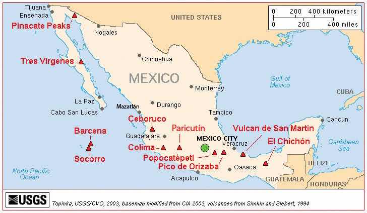
Source: Map courtesy of USGS/Cascades Volcano Observatory, http://vulcan.wr.usgs.gov/Volcanoes/Mexico/Maps/map_mexico_volcanoes.html.
Three tectonic plates underlie Mexico, making it one of the most seismically active regions on earth. In 1985, an earthquake centered off Mexico’s Pacific coast killed more than ten thousand people in Mexico City and did significant damage to the city’s infrastructure.
Many of Mexico’s natural resources lie beneath the surface. Mexico is rich in natural resources and has robust mining industries that tap large deposits of silver, copper, gold, lead, and zinc. Mexico also has a sizable supply of salt, fluorite, iron, manganese, sulfur, phosphate, tungsten, molybdenum, and gypsum. Natural gas and petroleum also make the list of Mexico’s natural resources and are important export products to the United States. There has been some concern about declining petroleum resources; however, new reserves are being found offshore in the Gulf of Mexico.
Though only about 13 percent of Mexico’s land area is cultivated, favorable climatic conditions mean that food products are also an important natural resource both for export and for the feeding the country’s sizable population. Tomatoes, maize (corn), vanilla, avocado, beans, cotton, coffee, sugarcane, and fruit are harvested in sizable quantities. Of these, coffee, cotton, sugarcane, tomatoes, and fruit are primarily grown for export, with most products bound for the United States.
Mexico has very pronounced wet and dry seasons. Most of the country receives rain between June and mid-October, with July being the wettest month. Much less rain occurs during the other months: February is usually the driest month. More importantly, Mexico lies in the middle of the hurricane belt, and all regions of both coasts are at risk for these storms between June and November. Hurricanes along the Pacific coast are much less frequent and less violent than those along Mexico’s Gulf and Caribbean coasts. Hurricanes can cause extensive damage to infrastructure along the coasts where major tourist resorts are located. Mexico’s extensive and beautiful coastlines provide an important boon to the nation’s tourism industry.
In the past few decades, the Mexican economy has slowly become less centralized and more focused on the private sector. The Mexican economy is a mix of modern industry, agriculture, and tourism. Current estimates indicate that the service sector makes up about 60 percent of the economy, followed by the industrial sector at 33 percent. Agriculture represents just above 4 percent. Per-capita income in Mexico is about one-third of what it is in the United States. The Mexican labor force is estimated at forty-six million individuals; 14 percent of the labor force work in agriculture, 23 percent in the industrial sector, and 62 percent in the service sector.
Mexico is an example of a country with a clear core-periphery spatial relationship. Mexico City and its surrounding metropolitan centers represent the county’s core: the center of activity, industry, wealth, and power. Industries and manufacturing have been traditionally located in this region. The core region has most of the country’s 110 million people (as of 2010). Mexico’s population is about 77 percent urban, with the largest urban areas found in the core region.
Figure 5.7 Mexican Economic Core Area Centered on Urban Areas around Mexico City
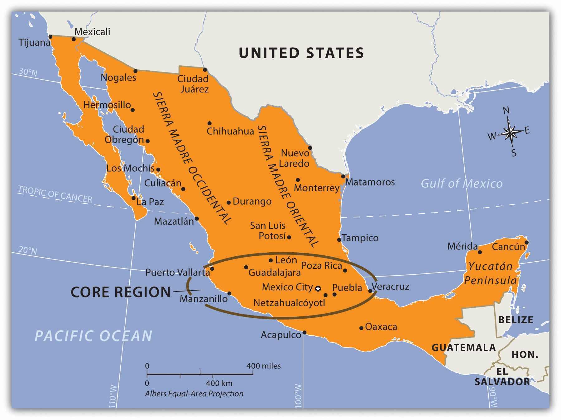
The periphery is the northern region, including the border area, and the southern region, including the Yucatán Peninsula.
Mexico City is one of the largest cities in the world and anchors the core region of Mexico. In 2010, the official population of Mexico City was about eighteen million, but unofficial population estimates can reach thirty million. The actual population of Mexico City is unknown because of the hundreds of slums that surround the city on the slopes of the central valley. Mexico City is growing at a rate of more than one thousand people per day through a combination of the number of births and the number migrants. The lure of opportunities and advantages still pulls migrants to the city in search of a better life. Higher populations tax the resources in rural areas, where jobs and opportunities are hard to find. This push-pull relationship creates a strong rural-to-urban shift in Mexico. This same trend is found throughout the developing world.
Figure 5.8 Mexico City on a Clear Day with the Ridge of the Mountains Visible in the Background
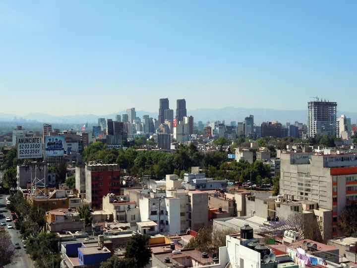
A day with extensive air pollution will restrict the view of the horizon.
Source: Photo courtesy of Matthew Rutledge, http://www.flickr.com/photos/rutlo/5446309874/in/photostream.
Mexico City is a historic and vibrant city, but is not without problems. At higher than seven thousand feet in elevation, it is located between two mountain ranges. Air pollution is severe and is augmented by frequent air inversions that trap pollution over the city. To reduce air pollution, people are only allowed to drive their vehicles on certain days according to odd or even license plate numbers. Older vehicles that do not pass emission standards are banned. Fresh water is in short supply, and wastewater from sewage is discharged into lakes down the valley. Amerindians who live by these lakes or on the islands have to deal with the pollution. Because about four to five million inhabitants of Mexico City have no utilities, human waste buildup has become a challenge. Fresh water is pumped into the city through pipelines from across the mountains. Leakage and inadequate maintenance cause a large percentage of the water to be lost before it can be used in the city. Water is also drawn from underground aquifers beneath the city, which has caused parts of the city to sink as much as two feet, causing serious structural damage to historic buildings.
Figure 5.9 Mayan Home in the Rural Village of Yachachen in the Yucatán Peninsula
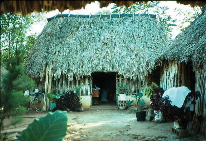
This is located in a peripheral region of Mexico.
Source: Photo by R. Berglee.
One of Mexico’s largest peripheral regions lies to the south, along the country’s border with Guatemala. It includes the state of Chiapas and most of the Yucatán Peninsula and is primarily inhabited by Amerindians of Mayan ancestry. As is typical of peripheral regions, little political or economic power is held by the residents, who find themselves at the lowest end of the social and economic order. The highland region of Chiapas and the Yucatán Peninsula are primarily agricultural regions with few industries. However, tourism has changed the northern Yucatán: Cancún has developed into a major tourist destination, and Mayan ruins in the region attract thousands of tourists each season. Unless the local population can benefit from tourism, there are few other opportunities for employment in this part of Mexico.
The early European control of the land, the economy, and the political system created conflict for the people of Mexico. The country has experienced domination followed by revolution at various times, starting with colonial domination, then economic domination, and lastly political domination. In each historic cycle, revolution and conflict were followed by change. The result was a mixing and acculturation of the Europeans and the Amerindians, which created the current mestizo mainstream society. Mestizos make up about 60 percent of the current population, Europeans make up about 9 percent, and Amerindians make up about 30 percent. More than sixty indigenous languages spoken by Amerindian groups are recognized in Mexico. At least seventeen indigenous languages are spoken by more than one hundred thousand people or more in Mexico, most of them living in the southern part of the country.
Mexican society is regionally and ethnically diverse, with sharp socioeconomic divisions. Many rural communities have strong ties with their regions and are often referred to as patrias chicas (“small homelands”), which helps to perpetuate the cultural diversity. The large number of indigenous languages and customs, especially in the southern parts of Mexico, further emphasize cultural diversity. Idigenismo (“pride in the indigenous heritage”) has been a unifying theme of Mexico since the 1930s. However, daily life in Mexico can be dramatically different according to socioeconomic class, gender, ethnicity, rural or urban settlements, and other cultural differences. A peasant farmer in the rainforests of the Yucatán will lead a very different life than a museum curator in Mexico City or a lower-middle-class auto factory worker in Monterrey.
Figure 5.10 Socioeconomic Classes in Mexico and Most of Latin America

The current social status of Mexican society can be illustrated by a pyramid shape (see Figure 5.10 "Socioeconomic Classes in Mexico and Most of Latin America"). Those of European descent are at the top of the pyramid and control a higher percentage of the wealth and power even though they are a minority of the population. The small middle class is largely mestizo, including managers, business people, and professionals. The working poor make up most of the population at the bottom of the pyramid. The lower class contains the highest percentage of people of Amerindian descent or, in the case of the Caribbean, African descent.
The most desirable type of social structure is illustrated by a diamond shape: in the middle is a large, employed middle class that can pay most of the taxes and purchase consumer goods that help bolster the economy. The narrow top is made up of the richest, and the narrow bottom is made up of the poorest (see Figure 5.11 "A More Ideal Socioeconomic Class Structure with a Large Middle-Class Tax Base"). Unfortunately, this optimal type of social structure does not always materialize in the manner hoped for. As an example, a goal of the economic planners of the United States has been to create a wide social profile. Unfortunately, in recent decades the US middle class has been declining, and the wealthy class and the working-class poor have increased. In Mexico, about 40 percent of the population lives in poverty.
Figure 5.11 A More Ideal Socioeconomic Class Structure with a Large Middle-Class Tax Base

Over the course of the past century, the people of Mexico have been working through a demographic transition. As the rural regions of Mexico continued to have a high fertility rate, death rates declined, and the country’s population grew exponentially. In 1970, the population of Mexico was about fifty million. By the year 2000, it had doubled to more than one hundred million. However, the population estimate for 2010 was just greater than 110 million. As Mexico urbanizes and industrializes, family size and fertility rates have been in decline, and population growth has slowed.
Figure 5.12 Population Pyramids for Mexico in 1980 and 2010
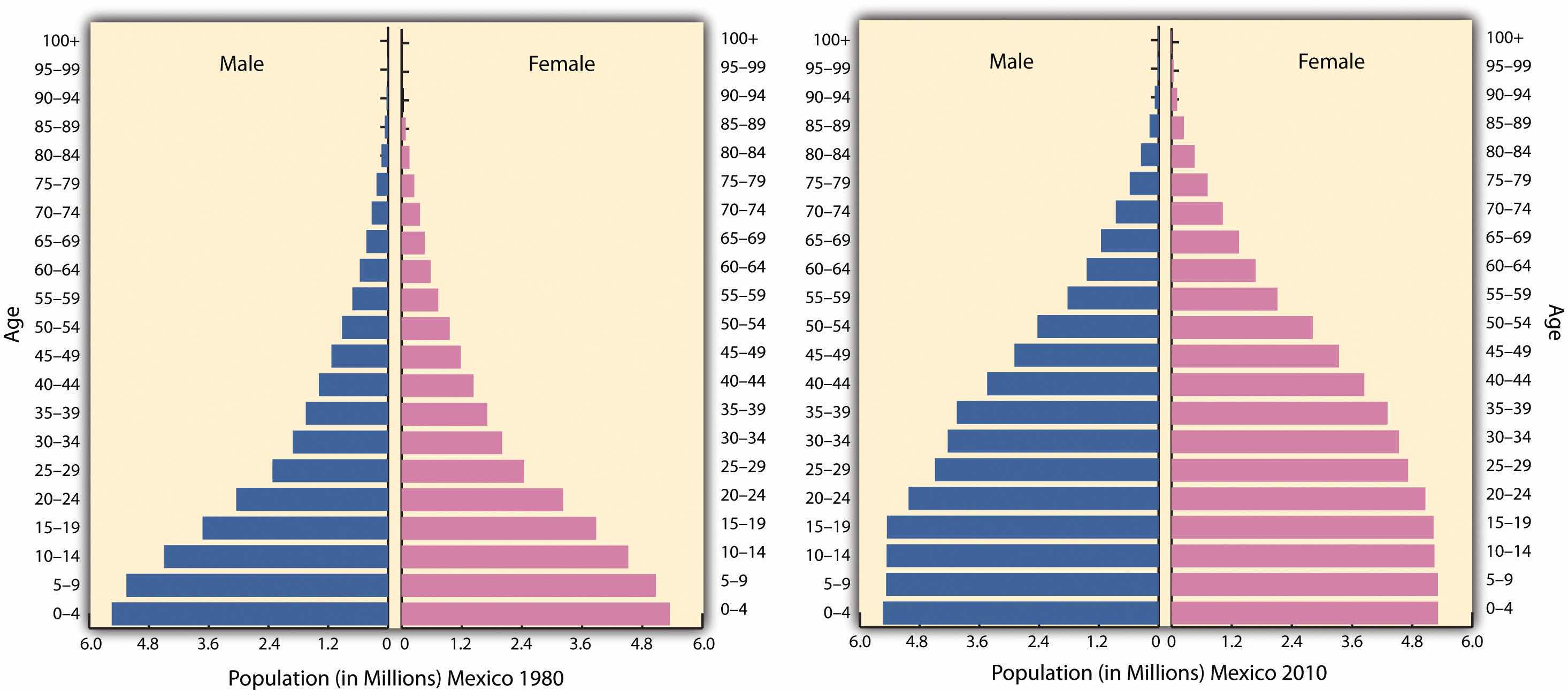
Population pyramids for Mexico in 1980 and again in 2010. The 1980 pyramid indicates rapid population growth. The 2010 pyramid illustrates a slight decline in the past few years.
Source: Data courtesy of US Census Bureau International Programs.
Rural-to-urban shift has increased the population of Mexico City, which is considered the primate city of the country. Rural Amerindian groups in the isolated and remote mountainous regions of Mexico have historically been self-sufficient for their daily needs and have relied on the land for their livelihoods. In the past few decades, however, large family sizes have forced many young people to look to the cities for employment. On a global scale, people in many countries are migrating from the periphery to the core.
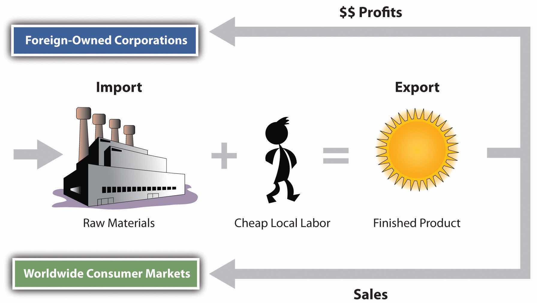
The North American Free Trade Agreement (NAFTA), is a 1994 economic agreement between Canada, the United States, and Mexico that eliminated or reduced the tariffs, taxes, and quotas between the countries to create the world’s largest trading bloc to compete with the European Union and the global economy. This theoretically allows more corporate investments across borders and increases foreign ownership of business facilities. It stimulated a shift in the location of industrial activity and in the migration patterns of people in Mexico. Capitalizing on the old industrial locations of northern Mexico, such as Monterrey, corporations started to relocate manufacturing plants from the United States to the Mexican side of the border to take advantage of Mexico’s low-cost labor. The aspect of cheaper labor was a benefit understood to bolster corporate profits and reduce product costs. The United States is one of the world’s largest consumer markets, so these manufacturing plants, called maquiladorasForeign-owned factories in Mexico that import most of the raw materials or components, assemble or process the product with local cheap labor, and export the finished product for profit. (also known as maquilas), could benefit both countries.
Maquiladoras are foreign-owned factories that import most of the raw materials or components needed for the products they manufacture, assemble, or process with local cheap labor, and then they export the finished product for profit. US corporations own more than half the maquiladoras in Mexico, and about 80 percent of the finished goods are exported back to the United States. Although most maquiladoras are located near the US-Mexican border, additional factories are located around Monterrey and other cities with easy access to the United States. A major trade corridor is developing between Monterrey and Dallas/Ft. Worth, which acts as a doorway to the US markets.
Figure 5.13 Import/Export System of a Maquiladora Operation
Thousands of maquiladoras flourish along the US-Mexican border, although the Mexican government has also promoted maquiladoras in other parts of Mexico. Maquiladoras provide jobs for workers in Mexico and provide cheaper goods for US consumers. However, this system has inherent problems. Labor unions in the United States complain that the high-paying industrial jobs that support the US middle class are being lost to cheap Mexican labor. Labor laws in Mexico are less rigorous than US laws, allowing for longer work hours and fewer benefits for maquiladora employees. In addition, pollution standards in Mexico are not as restrictive as those in the United States, giving rise to environmental concerns. The central US-Mexican border region has dry or arid type B climates with fresh water in short supply, and water is in high demand in industrial processes. With the rapid increase in employment along the border, many of the people who work in the factories do not have adequate housing or utilities. Extensive slum areas have grown around maquiladora zones, which have little law enforcement, high crime, and few services.
The US-Mexican border region has become a strong pull factor, enticing poor people who seek greater opportunities and advantages to move from Mexico City and other southern regions of Mexico to the border region to look for work. When they do not find work, they are tempted to cross the US border illegally. The United States is considered a land of opportunity and attracts immigrants—both legal and illegal—from Mexico. For political and economic reasons, the main US political parties have been hesitant to seriously address the problem of the millions of illegal immigrants.
Figure 5.14 US-Mexican Border
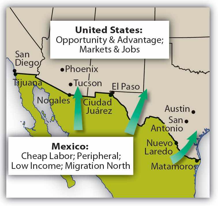
Opportunities and advantages drive the push-pull of migrants searching for improved economic conditions.
It is not only US corporations that have taken advantage of the explosion in the number of maquiladoras in Mexico. European and Japanese companies have also muscled in on a share of the market. Capitalism thrives on cheap labor and accessible raw materials. With much of this industrial activity located in the northern sector of Mexico, it becomes easier to understand the difficult issues that confront Mexico’s southernmost state of Chiapas, where there is little benefit from this growth of economic activity.
In 1995, Chile was considered a possible addition to the countries participating in NAFTA. US congressional differences, however, have prevented Chile from being accepted as a full member. As a result, Chile remains a “silent partner” and conducts business according to similar rules. Agreements with Chile block Asian goods from making their way into the United States through Chile and Mexico. The United States, Mexico, and Canada all have full-fledged independent free-trade agreements with Chile.
The Free Trade Area of the Americas (FTAA) is a plan to integrate the entire Western Hemisphere into one giant trading bloc. The same concerns that the European Union faced regarding currency, language, and law confront this proposal. A new currency called the Eagle was proposed as early as the 1990s to replace the Canadian dollar, the US dollar, and the Mexican peso. In later years, a currency called the Amero was proposed for the same purpose, but its implementation is unlikely. Any change in the US dollar would affect a great number of countries: Puerto Rico (a territory of the United States) and the countries of Ecuador, Panama, and El Salvador already use the US dollar as their standard currency. A one-currency solution might become a more viable option if the US dollar were to crash or significantly lose its value in the world marketplace.
A goal of NAFTA is to exploit cheap labor until the Mexican economy rises to a level similar to that of the United States and Canada, equalizing migration patterns and eventually bringing about a situation in which the border checkpoints between the countries could be eliminated, as they have been within the European Union. Through the development of a larger middle class in Mexico, the three main countries of NAFTA would have similar standards of living. Mexico has a long way to go to arrive at this status but is making progress at the expense of the United States and Canada. Corruption, organized crime, and drug wars have made progress in Mexico more difficult.
Critics of NAFTA claim that the term free trade really means corporate trade. NAFTA is also viewed as a component of globalization in the form of corporate colonialism, which only benefits those wealthy enough to hold investments at the corporate level. The exploitation of cheap labor has caused undue immigration across the US-Mexican border, bringing millions of illegal workers into the United States. The Mexican government has not adequately addressed Mexico’s economic conditions to provide jobs and opportunities for the people or to use the wealth held or controlled by the elite minority to enhance economic opportunities for the middle- and lower-class majority.
Figure 5.15 Labor and Resources in Globalization

Slave labor was prominent during European colonial era, whereas cheap labor is the target in neocolonial activity—that is, corporate colonialism.
The state of Chiapas in Mexico has an unequal distribution of wealth, a situation evident in most core-peripheral spatial relationships. Located in the rural highlands of Mexico and inhabited by a minority group that holds to the Mayan language and traditions, Chiapas has few economic opportunities for its people. Wealthy landowners and the ruling elite who have long held power have routinely taken advantage of peasant farmers. The aristocracy uses the best land and pays low wages to local workers. Medical care, education, and government assistance have been slow in coming to this region and its people.
In the past few decades, various Amerindian groups have organized in the rural areas of Mexico in an attempt to counter the power of the political elite. In Chiapas a group calling itself the Zapatista National Liberation Army (ZNLA) organized to coordinate an offensive against the Mexican government in various towns in the region. The ZNLA was organized to coincide with the implementation of NAFTA among the United States, Canada, and Mexico in January of 1994. As each country claimed benefits from this agreement, the peripheral region of Chiapas sought to receive their share of those benefits. The Mexican military was quick to react to the ZNLA offensive and rapidly drove them out of the towns they had occupied. The publicity and the international press coverage assisted the ZNLA in getting their message out to the rest of the world.
Since 1994, the ZNLA’s guerilla forces have used their familiarity with the mountains for sanctuary and have faced off against the Mexican military when negotiations with the federal government have broken down. The ZNLA want greater recognition of their rights and their heritage and more autonomy over their region and lands. This devolutionary process resembles that of various European regions desiring similar recognition of rights.
Similar conflicts are ongoing in other rural states of Mexico with majority Amerindian populations. There is a direct relationship between social status and wealth and skin color in most regions of Mexico. The skin tone is directly related to a person’s social status. On the one hand, Aztec and Mayan heritage is celebrated; on the other hand, their identity and darker skin relegates them to a lower socioeconomic status.
The illegal drug trade is a multibillion-dollar industry, and Mexico has traditionally been the transitional area or stop-off point between the South American drug producing areas and entrance into US markets. Cocaine, marijuana, and more recently heroin were produced in the Andes Mountains of South America and shipped north to the United States. Colombian cartels were once the main controllers of illegal drugs in the Western Hemisphere, but in recent decades, organized crime units in Mexico have muscled in on the control of drugs coming through Mexico, making deals with their South American counterparts to become the main traffickers of drugs into the United States, and the influence and power of Mexican drug cartels has increased immensely since the demise of the Colombian cartels in the 1990s. Enormous profits fuel the competition for control. Just as the United States has declared a war on drugs and has used its Drug Enforcement Administration (DEA) as a main arm in combating the industry, Mexico has had to address its own issues in the illegal drug trade.
Illegal drug income flowing into Mexico has become a major part of the economy in specific areas. Drug kingpins have used their economic power to buy off local police forces and silence opposition. They have also been known to provide poor neighborhoods with funding for services that would normally be designated as government obligations. These actions have often provided a mixed reaction within the population in local areas. The drug cartels have become an integrated part of the fabric of Mexico.
In an attempt to combat the situation, the Mexican government has been engaged in its own internal war against the illegal drug trade. The battles between the drug cartels and the Mexican government have created a serious internal conflict in the country, killing thousands of innocent bystanders in the cross fire. Armed conflicts between rival cartels or local gangs have increased the violence that has been intensifying since 2000. Mexican cities near the US border have experienced increased incidences of major drug-related murders and gang violence. Higher volumes of firearms trafficking from the United States and abroad into Mexico have been fueling the armed conflicts. Military and police casualties have increased, and the number of drug-related shootings are on the rise.
Figure 5.16 Influence of Major Drug Cartels in Mexico
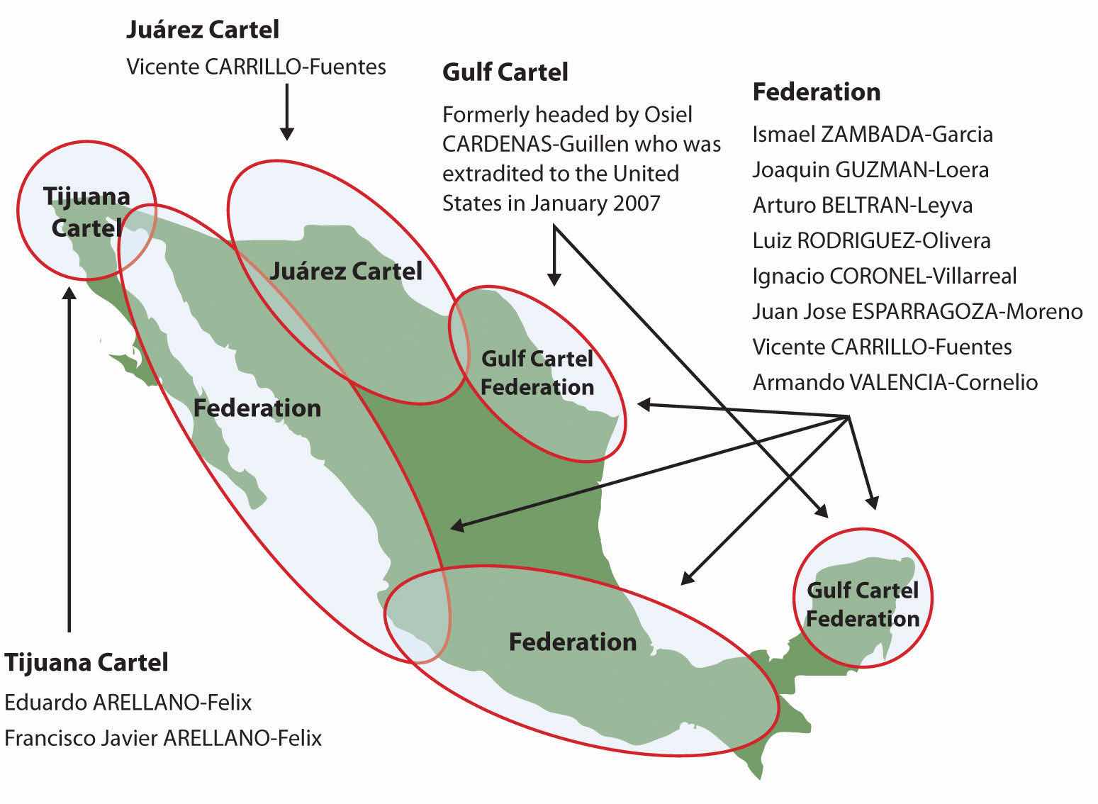
Source: Map courtesy of US Congress, Committee on Foreign Relations, http://frwebgate.access.gpo.gov/cgi-bin/getdoc.cgi?dbname=110_cong_senate_committee_prints&docid=f:39644.pdf.
Cartels have been known to use jet airliners, semitrucks, and even submarines in their attempts to ship illegal drugs into the United States. Large tunnels have been found beneath the US-Mexican border that were used to smuggle drugs. Intimidation and corruption have been standard practices used by drug traffickers to protect their interests. Bribes, payoffs, and corruption have been difficult to battle in a country with a high percentage of the population living in poor conditions.
Identify the following key places on a map:


