 Print this chapter
GEOG101 Study Guide
Unit 6: South America
6a. Summarize the main physical features and characteristics of South America
- What landforms and land cover types characterize South America's physical landscape?
- How do South America's location and landforms affect its climate?
- Where are the agricultural regions of South America?
Given the size of South America, it is no surprise that it has a varied physical landscape, including mountain ranges, valleys, rivers, lakes, deserts, plains, plateaus, and highlands.
- As the longest mountain chain on Earth, the Andes Mountains form the west coast of the continent. This area is tectonically active.
- The valleys, or altiplanos, between the Andes mountain ranges provide fertile agricultural land.
- South America's plateaus, plains, and highlands are also agricultural regions, including, for example, the Pampas and the Mato Grosso Plateau.
- Some highlands, such as the Guiana Highlands are too rugged and remote for agricultural activity.
- Although many people associate the Amazon River Basin with Brazil, it covers more than a third of the continent, including Peru and Ecuador to the west, Bolivia to the south, and Colombia, Venezuela, and other northern countries.
- Tropical forests are an iconic image of South America but the realm is also home to the driest non-polar desert in the world. The rain shadow effect of the Andes Mountains is responsible for the Atacama Desert of Chile and Peru.
The image of South America's climate is often associated with the tropical Amazon Rainforest. Not all of the continent, however, straddles the Equator. Because the South American continent extends from 12° N to 54°S, its climate varies, including tropical, temperate, arid, cold, and polar climate types. Furthermore, there are variations within those climate types due to local topography.
Review Introducing the Realm.
6b. Analyze colonial domination within South America and how the continent was divided
- Why did Spain colonize the west side of South American and Portugal the east side?
- What is the significance of the Tordesillas Line?
- How did the colonial experience of the Guianas differ from the rest of South America?
The countries of Europe's Iberian Peninsula, Spain and Portugal, colonized all of South America with the exception of the Guianas, present-day Guyana, Suriname, and French Guiana. As shown in the following figure, Spain's invasion of South America focused on the west coast because they were already in Middle America, which borders present-day Colombia. Francisco Pizzaro, a Spanish conquistador stationed in Panama, is credited with beginning the Spanish colonization of South America, landing in Peru to search for gold and silver. Portuguese colonists sailed directly to South America from Portugal, landing on the east coast in Brazil to seize land for the expansion of their empire.
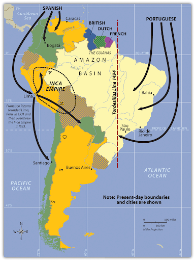
As the Spanish and Portuguese penetrated South America's interior from opposite directions, they eventually claimed the same territory. They turned to the Catholic church to resolve the dispute, establishing a boundary between the two, the Tordesillas Line of 1494. The British, Dutch, and French colonized the Guianas in much the same way they colonized the rimland of Middle America. French Guiana is the only remaining colony on the continent of South America.
Review:
- Introducing the Realm: the section on European Colonialism
- Urban North and Andean West: the sections on Colombia: Drugs, Coffee, and Oil and Rural Amerindian States of Ecuador, Peru, and Bolivia
- Brazil - The Amazon Basin: the section on A Portuguese Colony
- The Southern Cone: the section titled Population and Culture
6c. Identify the main cultural regions of South America
- What are the physical and human characteristics of South America that define the five main cultural regions?
- Why is the realm of South America more integrated now than when these cultural regions were delineated?
In some cases, the following map reflects both South America's physical and human geography.
- The Tropical Plantation Region represents the coastal edge the Portuguese colonized.
- The Rural Amerindian Region follows part of the Andes Mountain range. This is also an area that attracted Spanish conquistadors with its mineral resources.
- Although the Amazon Basin is much larger than the region shown on the map, it does represent the core of the Basin. Colonists did claim this territory even though it was, until the early 1970s, largely impenetrable.
- The Mixed Mestizo Region is less easily identified based on physical geography. Instead, it is a transition zone between wealthy and poor regions.
- The European Commercial Region, or Southern Core, includes the fertile soils of the South American realm. The agricultural activity here has contributed to the economic growth and European investment in the area.
Technology and globalization have integrated these regions to a certain extent but they still provide a useful framework from which to understand an entire realm.

Review the section titled Cultural Regions of South America in Introducing the Realm.
6d. Summarize the production of the three main export products of Colombia
- Where, in Colombia, are these products grown?
- What aspects of Colombia's physical geography contribute to the cultivation of these crops in Colombia?
Three of Colombia's main exports include cocaine, oil, and coffee.
- The coca plant that is used to make the drug cocaine grows on the low-altitude slopes of the Andes where the climate is tropical. These areas are typically remote, making it easier to cultivate without detection. In 2020, Colombia was still the world's largest cocaine producer.
- Colombia exports more oil, also known as petroleum, than any other product. Its petroleum resources are in sedimentary basins where there were once geologically ancient seas in the northwest and center of the country.
- After petroleum products and coal products, coffee is Colombia's biggest export. Colombia's physical geography is ideal with a tropical climate and mountains. Specialty coffees, in particular, grow best at elevations of 3,000 to 6,000 feet.
Gems and precious metals, particularly gold, are an increasingly important export. In 2020, they surpassed coffee in the percentage share of Colombia's exports.
Review the sections on Colombia in Urban North and Andean West.
6e. Compare the three main countries in the Andean West region of South America, describe how they gained their wealth, and identify who has benefited the most from that wealth
- What are the main exports of this region?
- What aspects of this region's physical landscape contribute to the economies of Ecuador, Peru, and Bolivia?
The Central Andes and the Amazon River Basin both contribute to the economies of the Andean West countries.
- The sedimentary basins that coincide with Ecuador, Peru, and Bolivia are adjacent to the Andes, on the periphery of the Amazon River Basin. Over 400 million years ago, these basins were seas that later filled with sediments, burying the ancient marine life that would eventually become petroleum and other fossil fuels. Petroleum is Ecuador's leading export and Peru's second-highest export. Natural gas and petroleum are Bolivia's leading exports.
- Mining precious and base metals, including gold, silver, copper, and zinc, among others make up significant portions of these countries' economies. Gold and copper are Peru's leading exports. Gold, zinc, and other precious and base metals are Bolivia's second-highest export. These mines, some of which date to the Spanish conquest, are found in the Andes Mountains.
Clearly, the Andean West has numerous natural resources but the people who live and work in these areas rarely benefit. Furthermore, they often suffer from dangerous working conditions and the environmental damage caused by these extractive industries. The land owners, wealthy elite, and international corporations profit from the abundant natural resources.
Review Urban North and Andean West.
6f. Discuss how Paraguay's geography allowed it to gain wealth and provided opportunities for its people
- What does Paraguay have in common with Bolivia?
- What limits Paraguay's economic growth?
Like Bolivia, Paraguay is a landlocked country. Unlike Bolivia, Paraguay is not in the Andes and has little in the way of natural resources. Paraguay's physical geography consists of dry, grassy plains, wooded hills, and marshlands; only about 10% of its land is arable. Paraguay must, however, rely on agriculture given its few natural resources. Its main exports are soybeans, beef, and electricity from its hydropower dams. In addition to Paraguay's limited natural resources, its economic growth potential is hindered by inadequate infrastructure, political instability, and corruption, all of which contribute to the crippling poverty of most Paraguayans, known colloquially as Guaranis.
Review the section on Paraguay in Urban North and Andean West.
6g. Summarize the ethnic composition of Brazil and discuss why the population is so diverse
- How does Brazil's colonial history differ from the rest of South America?
- What was the Atlantic Trade Triangle?
Unlike most of the other countries in the South American realm, Brazil was a Portuguese colony rather than a Spanish colony. Thus, Portuguese is the lingua franca of Brazil rather than Spanish. The population of Brazil is predominantly White, Multiracial, and Black. European immigration and African slaves explain much of the ethnic diversity of Brazil.
- The Portuguese were part of the Atlantic Trade Triangle, also known as triangular trade, which moved people and goods between Europe, Africa, and the Americas. The trade was not, however, equitable.
- Europe shipped goods to Africa to trade for slaves. The slaves were transported to the Americas to provide labor for the European colonists. The goods the slaves produced were shipped to Europe.
Portugal was the most active country in the slave trade. It is estimated they trafficked more than three million people from Africa to Brazil, more than any other country.
Review the section titled Northern Periphery: The Amazon Basin in Brazil - The Amazon Basin.
6h. Describe the main activities that are involved in the development and exploitation of the Amazon Basin
- What contributed to the growth of the port city of Manaus?
- What is the purpose of the Grande Carajás Project?
- Why is deforestation occurring in the Amazon rainforest?
Although many people are familiar with the exploitation of the Amazon Basin through deforestation, many are not aware of the varied reasons for the removal of large swaths of the Amazon rainforest. Loggers harvest trees for wood products, ranchers clear the land to raise cattle, and miners remove trees to extract precious and base metals, including gold and copper, and iron ore. The Grande Carajás Project facilitates the exploitation of the region by providing the infrastructure needed to support increased mining activity.
Humans have long recognized the value of the Amazon Basin's natural resources. The river port city of Manaus, for example, attracted increasing European attention during the late 19th century because it was a gateway to rubber. Manaus' location on the Rio Negro, a large tributary to the Amazon River, made it possible to easily access the interior of the Amazon rainforest and then ship the extracted rubber to the outside world.
Review the section titled A Portuguese Colony in Brazil - The Amazon Basin.
6i. List the physical characteristics of the various regions of Brazil
- How has the physical landscape of the south region contributed to its affluence?
- Why does the west central region have great agricultural potential?
There is agricultural activity in all of Brazil's regions but the southeast region has been particularly successful due to its good soils, coastal location, and temperate climate. Farmers grow wine grapes, rice, and tobacco. In addition to its success in agriculture, this region also produces all of Brazil's coal.
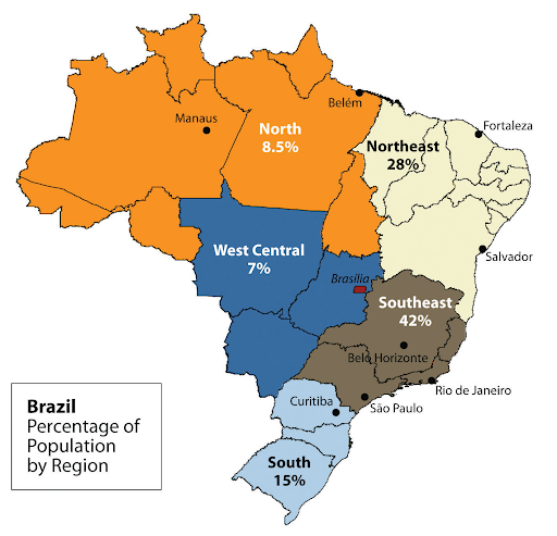
The west central region includes a tropical savanna ecoregion known as the cerrado. Until recently, it was considered unsuitable for agriculture because the soil quality is poor. The increase in population in the fertile southeast region, shown in the following figure, has, however, forced Brazil to adapt conditions in the west to accommodate agricultural activity. Thus, the soil is being enhanced by adding phosphorus and lime to grow soybeans, grains, and cotton. It is anticipated that the agricultural potential of the west central region will expand even more in the future.
Review Brazil - The Amazon Basin.
6j. Explain the pattern of immigration that created the regional heritage of the Southern Cone
- In terms of ethnic diversity, how does Argentina differ from other countries in South America?
- What was it about the physical geography of the Chaco region that attracted Mennonite immigrants from other countries?
Argentina's population includes people who can trace their ancestry to far more European countries than the rest of South America. Some of these people are descendants of European colonists, but many more are there due to immigration in the 19th and 20th centuries.
- When Argentina declared independence in 1816, it was sparsely populated.
- To remedy that, the government began a campaign in the mid-19th century to bring European immigrants to the country.
- Argentina was second only to the United States in the number of immigrants arriving between 1857 and 1950.
- Immigrants arrived from Italy, Scandinavia, Greece, Ireland, France, Germany, Bulgaria, and many other European countries and Russia.
- More recently, Argentina is a destination for immigrants from southwest Asia.
The Chaco region's rainfall and soils make it an ideal place for farming. Thus, it was an attractive destination for Mennonites, members of the Anabaptist Christian denomination who often live off the land. The Mennonites arriving from Canada sought to do missionary work among the Amerindians in addition to farming, whereas the Mennonites arriving from Russia were fleeing oppression and the loss of their farms at the hands of the Soviets. Today, there are Mennonite communities from all over the world now living in South America.
Review The Southern Core.
6k. Discuss how Chile has emerged as a strong and stable country
- What are Chile's natural resources?
- What has Chile done to counter the economic instability associated with natural resource price fluctuations?
All three of Chile's regions provide natural resources that contribute to its strength and stability.
- Northern Chile's Atacama Desert is a source of minerals, including copper.
- Chile's Central Valley, with its Mediterranean climate, produces a variety of agricultural products, including wine, fruits and vegetables, grains, and beef.
- Southern Chile's forests provide timber resources.
- Chile's extensive coastline provides access to another natural resource, fish. Fishing is a major industry in Chile.
Chile relies on natural resources such as copper that experience price fluctuations. This fluctuation causes uncertainty in the market. To avoid this economic instability, Chile has been proactive in its efforts to diversify its economy by expanding into manufacturing. Chile's manufacturing efforts include textiles, basic chemicals and electronics, among other products.
Review the section on Chile in The Southern Core.
Unit 6 Vocabulary
This vocabulary list includes terms that students need to know to successfully complete the final exam for the course.
- altiplanos
- Amazon rainforest
- Amazon River
- Amazon River Basin
- Amerindian
- Andean West
- Andes
- Argentina
- Atacama Desert
- Atlantic Trade Triangle
- arid climate
- Brazil
- Central Andes
- Central Valley
- cerrado
- cold climate
- deforestation
- exports
- Francisco Pizzaro
- Grande Carajás Project
- Guaranis
- Guiana Highlands
- landlocked
- Manaus
- manufacturing
- Mato Grosso Plateau
- Mennonites
- Mixed Mestizo Region
- Pampas
- Paraguay
- polar climate
- price fluctuations
- rain shadow effect
- remote
- Rio Negro
- Rural Amerindian Region
- slave trade
- South America
- Southern Core
- tectonically active
- temperate climate
- Tordesillas Line
- triangular trade
- tropical climate
- tropical forests
- Tropical Plantation Region